The new robotic Mars rover landed at the foot of a fan-shaped sediment deposit reminiscent of formations in Death Valley.
Published Aug 16, 2012
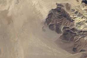
Despite frigid temperatures, Antarctica’s Don Juan Pond rarely freezes.
Published Dec 28, 2014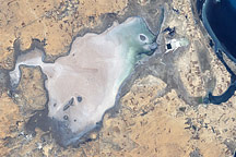
Along Tunisia’s southeastern coast is a flat plain of about 150 square kilometers (58 square miles) that lies below sea level. Known as Sebkhat El Melah (or Sebkha El Melah), it is in an evaporite basin.
Published Dec 7, 2008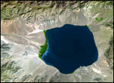
The Uvs Nuur Basin sits on the northern edge of the Central Asian steppes, bounded on all sides by mountains. Though largely arid, the basin is dotted with water. A large salt lake, the Uvs Nuur Lake, sits at the center of the basin, and several smaller lakes are scattered across the 600 kilometers east to west and 120 kilometers north to south that make up the basin.
Published Oct 11, 2007
As the spacecraft headed into its last days, it sent back this image of Earth framed by Saturn’s rings.
Published Apr 29, 2017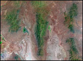
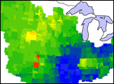
These images show how terrestrial water storage in the four major sub-basins of the United States’ Mississippi River basin differed from average in January and July 2005.
Published Jan 26, 2007
Sixteen operating satellites monitor Earth. Four more are scheduled to launch in 2014.
Published Jul 5, 2013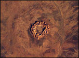
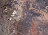
This image shows Gosses Bluff, an impact crater sandwiched between the Macdonnell Range to the north and the James Range to the south in Australia’s Northern Territory—it is about 160 km west of Alice Springs. It is one of the most studied of the Australian impact craters. The impactor, an asteroid or comet, was probably about 1 km in diameter and crashed into the earth about 142 million years ago.
Published Jun 15, 2003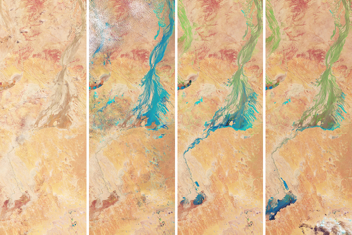
Flood water from northern Queensland drained toward a large basin in Australia’s interior—painting the desert landscape green.
Published May 4, 2018
OSIRIS-REx took a look back at home while making its way toward the asteroid Bennu.
Published Dec 31, 2017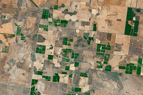
Water is an important but sometimes scarce commodity for farmers in the Murray-Darling basin of southeast Australia.
Published Feb 26, 2016
On July 19, 2013, NASA spacecraft got not one but two rare and unique views of Earth from opposite ends of the solar system.
Published Jul 24, 2013
The MarCO-B CubeSat snapped its first photo on May 9, 2018, and caught a glance of home.
Published May 28, 2018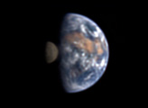
From 31 million miles away, how could you tell that there was life on Earth? Scientists used the remote vantage point of NASA’s Deep Impact spacecraft to shoot a sequence of images that will help to help answer that question.
Published Jul 22, 2008
The Curiosity rover on Mars looked up and saw home on the horizon.
Published Mar 9, 2014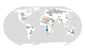
About one third of Earth’s large groundwater basins are being rapidly depleted by human consumption even though we have little accurate data about how much water remains in them.
Published Jul 24, 2015
When the Apollo 11 astronauts left the surface of the Moon on July 21, 1969, they brought home samples of solar wind particles, lunar rocks and dirt, and a big helping of perspective.
Published Jul 20, 2019