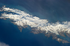
Astronauts capture a view of the South Atlantic Island that looks like it has been taken from an airplane. Mountains and glaciers stand in stark relief against the sea.
Published Apr 29, 2013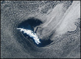
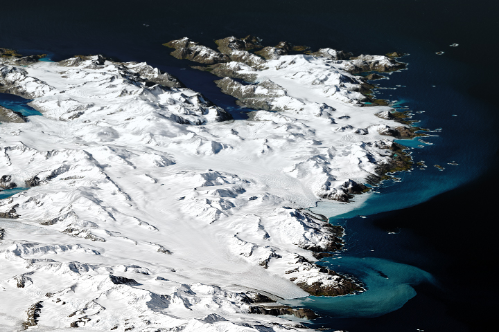
The remote island may be inhospitable to humans, but it provides a home to major populations of wildlife.
Published Mar 4, 2019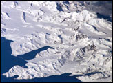
There is no permanent human base on South Georgia Island, a British territory in the South Atlantic Ocean that lies 1,300 kilometers east of the Falkland Islands. The crew of the International Space Station captured this image of the rugged and isolated landscape of the northern shore of the island. The first recorded explorer to land on the island was Captain James Cook aboard the HMS Resolution in 1775. He mapped part of the coastline, but was discouraged by the thick ice cover, lack of vegetation, and steep mountains. Mt. Paget, the highest peak, rises to 2,934 meters (9,625 feet) above sea level, and the island supports 161 glaciers. Cook named the southernmost point of the island “Cape Disappointment” when he realized he had not reached Antarctica.
Published Oct 17, 2005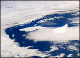
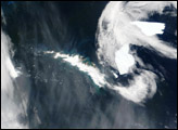
These photographs, taken from the International Space Station in January, 2004, show two pieces of a massive iceberg that broke off from the Ronne Ice Shelf in October, 1998. The pieces of iceberg A-38 have floated relatively close to South Georgia Island. After 5 years and 3 months adrift, they are approximately 1,500 nautical miles from their origin. In the oblique image, taken a few minutes later, the cloud pattern reveals the impact of the mountainous islands on the local wind field. At this time, the icebergs are sheltered in the lee side of the island.
Published Jan 26, 2004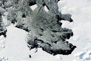
Over the course of five months in Antarctic spring and summer, NASA’s Terra and Aqua satellites captured a series of images of ice island B31.
Published Apr 18, 2014
Thermal infrared imagery shows the ice island—which calved off of Pine Island Glacier—after winter darkness has set in.
Published May 15, 2014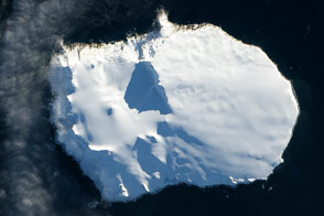
Bouvet Island, a territory of Norway, is one of the most remote islands in the world.
Published Feb 26, 2014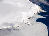
Bouvet Island is known as the most remote island in the world; Antarctica, over 1600 kilometers (994 miles) to the south, is the nearest land mass. Located near the junction between the South American, African, and Antarctic tectonic plates, the island is mostly formed from a shield volcano—a broad, gently sloping cone formed by thin, fluid lavas—that is almost entirely covered by glaciers.
Published Oct 6, 2008
This image could be a scene out of a spooky movie, but the reality is just as morbid.
Published Oct 31, 2018
The mega-iceberg A53a (upper image) measured close to 50 kilometers by 22 kilometers, about seven times the area of Manhattan Island, in mid-January 2008 when astronauts took the photographs for this mosaic. The images were acquired from the International Space Station (ISS), located 780 kilometers to the north of the iceberg at an altitude of 341 kilometers; the perspective distorts the oblong shape of the iceberg, making it look squarer than it actually is.
Published Feb 25, 2008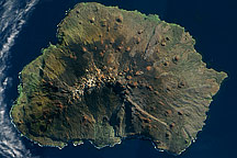
Acquired on on May 5, 2009, this true-color image shows Marion Island in the Indian Ocean. Sparsely vegetated, this volcanic island has remnants of snow near its summit.
Published Oct 18, 2009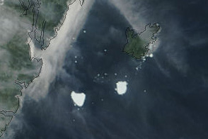
Acquired August 22, 2011, this natural-color image shows the Petermann Ice Island-A split in two off the Newfoundland coast.
Published Aug 23, 2011