The recent discovery of the Mammerickx Microplate was made possible by new satellite-derived maps of the ocean floor.
Published Jan 13, 2016
Submerged in the Atlantic Ocean off the coast of Spain and Portugal are giant, salty whirlpools of warm water. These deep-water whirlpools are part of the ocean’s circulatory system, and they help drive the ocean currents that moderate Earth’s climate. Warm water ordinarily sits at the ocean’s surface, but the warm water flowing out of the Mediterranean Sea is so salty (and therefore dense) that when it enters the Atlantic Ocean at the Strait of Gibraltar, it sinks to depths of more than 1,000 meters (one-half mile) along the continental shelf. This underwater river then separates into clockwise-flowing eddies that may continue to spin westward for more than two years, often coalescing with other eddies to form giant, salty whirlpools that may stretch for hundreds of miles. Because the eddies originate from the Mediterranean Sea, scientists call them “Meddies.”
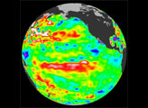
Published Mar 23, 2006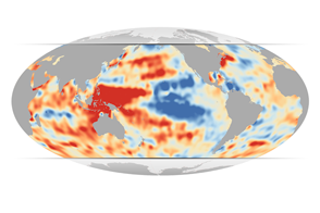
Examining temperatures from the depths of the ocean, JPL scientists have found that lower layers of the Western Pacific and Indian Oceans grew much warmer during a decade when surface temperatures cooled.
Published Jul 10, 2015
What do oceanographers and astronauts have in common? Observations of the complex interactions between different Earth systems, for one. Astronauts aboard the International Space Station routinely observe and photograph the Earth’s surface to visualize the complicated interfaces between the atmosphere, the ocean, the land, and life on the surface. Oceanographers are also interdisciplinary students of the Earth; their interests include geology, chemistry, hydrology, and biology. Currently, a team of scientists is cruising the eastern Pacific Ocean off the coast of Mexico and is preparing for submersible dives on the East Pacific Rise, part of the world’s mid-ocean ridge system.
Published Jan 23, 2007
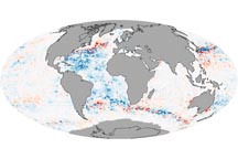
When scientists corrected errors in ocean temperature data, a mysterious cooling trend that appeared to occur between 2003 and 2005 disappeared.
Published Nov 6, 2008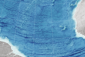
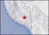
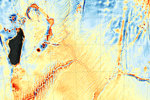
Scientists read the bumps on the ocean surface to understand the shape of the seafloor below.
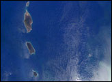
Published Dec 29, 2015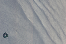
This image shows both internal waves and surface waves on the Indian Ocean near the Andaman Islands on March 6, 2007.
Published Jul 10, 2010
In several decades of observing the ocean with satellites, our vision has changed as much as the sea.
Published Apr 30, 2019
A Korean satellite provides an hourly view of the phytoplankton in the ocean, while also offering a testbed for future ocean-observing satellite missions.
Published Jun 21, 2016