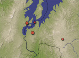
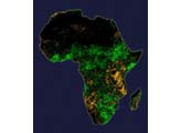
Using satellite data, scientists predicted an outbreak of Rift Valley fever in East Africa months before the first human cases were reported. The early prediction gave governments time to mitigate the spread of the disease.
Published Feb 15, 2009
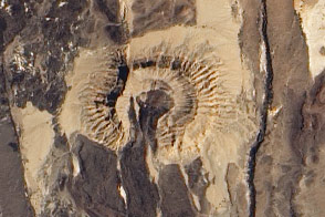
The landscape of the Afar region in northern Ethiopia results from tectonic forces working deep below the surface, both splitting Africa apart and producing volcanic eruptions. Lava from a November 2008 eruption at the Erta Ale Range remained visible months later.
Published Feb 4, 2009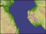
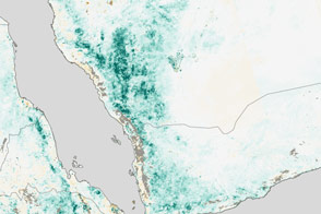
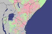
Rainfall has created conditions suitable for an outbreak of Rift Valley fever along coastal areas of Saudi Arabia and Yemen.
Published Jun 2, 2016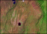
Acquired August 26, 2000, this false-color image shows part of Oslofjorden, a rift valley in southern Norway. At the northern tip of the rift valley sites Norway’s capital city.
Published Nov 14, 2010
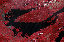
These images provide wide-area and close-up views of Suguta, today a mostly dry valley, several thousand years ago a massive lake.
Published Nov 20, 2011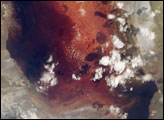
If Lake Natron, in Africa’s Great Rift Valley, had a color theme, it would be pink. The alkali salt crust on the surface of the lake is often colored red or pink by the salt-loving microorganisms that live there. Also, the lake is the only breeding area for the 2.5 million Lesser Flamingoes that live in the valley. These flamingoes flock along saline lakes in the region, where they feed on Spirulina, a blue-green algae with red pigments. This mosaic of photographs of the southern portion of Lake Natron shows the largest open lagoon area, and island mud flat, and a large area of pink salt crust. The colors show the actual colors viewed by the astronauts. Each time the lake is photographed, there are differences in the pattern of its salt crust, and the red colors of the blue-green algae and bacteria on the surface of the crust.
Published Apr 10, 2006