Images related to Magnitude 8.1 Earthquake off the Solomon Islands

Earthquake off Samoa Generates Tsunami
Image

Earthquake off Samoa Generates Tsunami

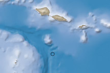
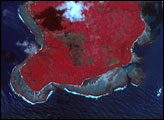
A large (magnitude 8.0) undersea earthquake near Samoa generated a destructive tsunami that killed over 100 people.

Published Oct 1, 2009

Image of the Day Land Earthquakes

Earthquakes in the Solomon Islands, Pacific Ocean
Image

Earthquakes in the Solomon Islands, Pacific Ocean

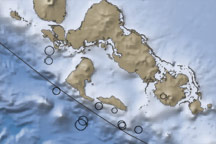
The contrast in ocean depths between the Australia Plate and the Pacific Plate near the Solomon islands reveals the subduction of the former beneath its northeastern neighbor. This subduction was responsible for the 7.2-magnitude quake on January 4, 2010.

Published Jan 5, 2010

Image of the Day Land

Tsunami Damage in Java
Image

Tsunami Damage in Java

Published Jul 21, 2006

Image of the Day Land Water

Tectonic Uplift near Sumatra
Image

Tectonic Uplift near Sumatra

Published Apr 27, 2005

Image of the Day Land

7.7 Magnitude Quake off Sumatra
Image

7.7 Magnitude Quake off Sumatra

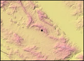
This image shows the topography, bathymetry, fault lines, and earthquake locations related to the earthquake that struck off the coast of Indonesia on October 25, 2010.

Published Oct 27, 2010

Image of the Day Land Earthquakes

Earthquake and Tsunami near Sendai, Japan
Image

Earthquake and Tsunami near Sendai, Japan

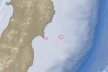
This map shows the location of a large aftershock off the coast of Japan on April 7, 2011.

Published Apr 7, 2011

Land Earthquakes