It was Texas hot when this view of the capital city of Austin was taken in late July by astronaut Ed Lu. Adding to the rising temperatures were heated debates in the Texas Capitol Building, where a special session had convened. Eleven senate Democrats thwarted a redistricting vote by disappearing from the state. Were Lu, and his Expedition 7 partner Yuri Malenchenko looking for the missing Democrats? We’ll never know. Astronauts have always enjoyed observing cities around the world. These images of Austin provide a 2003 baseline for monitoring its regional development and growth.
Published Aug 24, 2003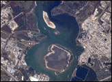
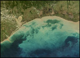
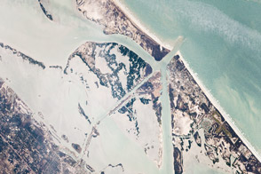
This astronaut photograph depicts the San Jacinto River portion of the Houston Ship Channel, one of the United States’ busiest sea ports. The channel is a conduit between the continental interior and the Gulf of Mexico for both petrochemical products and Midwestern grain. The original watercourse for the channel, Buffalo Bayou, has its headwaters thirty miles to the west of the city of Houston. It has been used to move goods to the sea since at least 1836. Wakes of ships traveling along the channel are visible to the south of the Goat Islands (bright, oblong islands at top center of image). The close proximity to Texas oilfields led to the establishment of numerous petrochemical refineries along the waterway, such as the ExxonMobil Baytown installation on the eastern bank of the San Jacinto River.
Published Dec 26, 2005
Astronauts on the Space Station had a glowing view of their professional home, as well as the site of Super Bowl 51.
Published Feb 4, 2017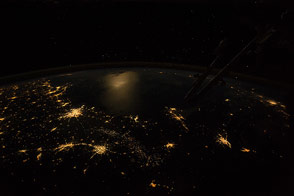
Cities, moonlight, and fossil-fuel industries frame the Gulf of Mexico with light.
Published Mar 23, 2015
The convention facilities, missions, The Alamo, and the overall historical character of the city bring 26 million visitors every year.
Published Jan 11, 2016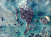
The compact Italian city of Venice with its renowned canals is situated on a small, fish-shaped island in the Laguna Veneta at the northwest corner of the Adriatic Sea. In this photo taken from the International Space Station by the Expedition 1 Crew on February 21, 2001, one can see part of the causeway connecting the city to the mainland. The sinuous Canal Grande bisecting the city is easily visible in this scene as is the larger Canal Giudecca to the west, which leads to the port facilities on the northwestern end of the island. For centuries, the low-lying city has successfully coped with the three-foot tidal range experienced at this end of the Adriatic Sea, and the series of barrier islands has offered some protection from storm waves. However, a combination of both regional land subsidence and recent slight rises in sea level pose a significant threat this historic city and its priceless art treasures.
Published Jul 8, 2001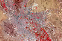
Though governed by separate countries, the cities of El Paso, Texas, and Juarez, Mexico, merge into an apparently seamless metropolis in this satellite image, but vegetation is confined mostly to the United States' side of the border.
Published Mar 15, 2009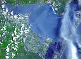
Sitting inside barrier islands of the eastern and southern United States—and cutting through them in points—the waterway provides a safer passage for shipping commerce.
Published Apr 7, 2014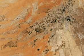
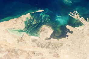
Several new farms, parks, gardens, and tree-planting projects have made Al Ain one of the greenest cities in the Middle East.
Published Sep 6, 2015
The historical oasis on the coast of the Arabian Gulf is now an oil industry oasis.
Published Jun 3, 2013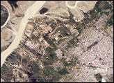
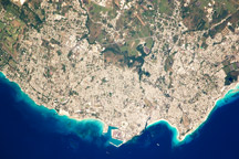
The port city of Bahía Blanca lies almost 600 kilometers southwest of Buenos Aires on the southern rim of the Argentine economic heartland. This small city of 275,000 people is located near the mouth of the Arroyo Naposta.
Published Mar 12, 2007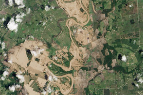
The Brazos River reached record-high water levels west of Houston.
Published Jun 3, 2016Image of the Day Land Water Floods Severe Storms Human Presence
Taken December 16, 2009, this astronaut photograph shows the greater metropolitan area of Bridgetown, Barbados. Gray-and-white urban areas along the coast contrast with green vegetation inland.
Published Jan 18, 2010