
In the Jordan rift valley, the continents of Africa and Asia are pulling apart from each other, and the land in between has been subsiding for millennia. The sinking has created the Dead Sea.
Published Dec 25, 2005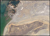
The arrow-shaped island in the Aral Sea used to be a 35-kilometer-long visual marker, indicating the Aral Sea to astronauts. An image from the present International Space Station increment shows how much the coastline has changed as the sea level has dropped during the last three decades.
Published Aug 15, 2005
As water levels drop in the Dead Sea, salt is piling up on the lakebed.
Published Jul 31, 2019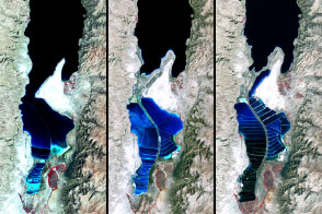
The lake between Israel and Jordan provides a bounty of salt and of history.
Published Apr 6, 2012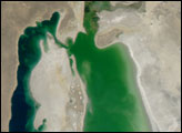
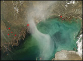
A hazy plume drifted over the northern end of the Caspian Sea in early April 2008. The translucent plume swirling over the water contrasts with the nearby opaque white clouds. The plume might result partly from smoke from springtime agricultural fires in farmland north of the sea.
Published Apr 16, 2008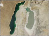
A Soviet-era plan to turn the arid plains of Kazakhstan, Uzbekistan, and Turkmenistan into fertile cropland resulted in the near-total diversion of the water that once fed the Aral Sea. Prior to the scheme, two rivers—the Amudar’ya in the south and the Syrdar’ya in the north—flowed out of distant mountains and pooled in a desert basin in what is now southern Kazakhstan and northern Uzbekistan. The irrigation project began in the mid-1900s, and by 1960, the sea had already begun to dry out.
Published Aug 26, 2008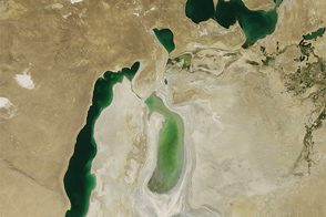
Once the world’s fourth largest lake, the rapidly shrinking Aral Sea has fragmented into four bodies of water. The Southern Aral Sea and Tsche-Bas Gulf show the most dramatic change in 2011.
Published Sep 11, 2011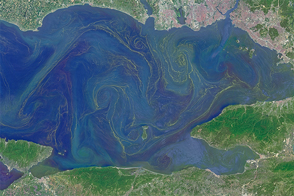
Freshened surface water and abundant nutrients lead to an explosion of algae in the inland sea.
Published May 31, 2015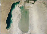
stronauts aboard the International Space Station (ISS) took this image of a major dust storm (image center and right) along the east side of the Aral Sea while passing over central Asia in the spring of 2007. The white, irregular lines along the bottom of the image are salt and clay deposits on the present coastline. The day that the ISS crew shot the image, winds were blowing from the west (lower left).
Published Nov 5, 2007