Astronauts aboard the International Space Station (ISS) took this photograph of the San Francisco Bay area in April, 2002. The gray urban footprint of San Francisco, Oakland, San Jose, and their surrounding suburbs contrast strongly with the green hillsides. Of particular note are the Pacific Ocean water patterns that are highlighted in the sun glint. Sets of internal waves traveling east impinge on the coastline south of San Francisco. At the same time, fresher bay water flows out from the bay beneath the Golden Gate Bridge, creating a large plume traveling westward. Tidal current channels suggest the tidal flow deep in thebay. Because the ISS orbits are not synchronous with the sun, astronauts view the Earth with variable solar illumination angles. This allows them to document phenomena such as the sun reflecting differentially off surface waters in a way that outlines complicated water structures.
Published May 26, 2002
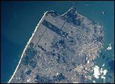
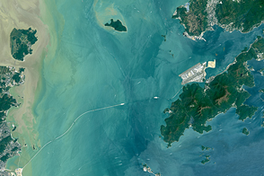
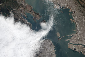
his image shows a photograph of San Francisco taken as the International Space Station passed 383 km overhead on November 10, 2000. The view includes the area stretching from the Golden Gate Bridge in the north to the San Mateo Bridge on the southeast.
Published Feb 25, 2001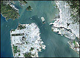
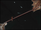
Once completed, the Hong Kong-Zhuhai-Macau Bridge will be one of the longest water crossings in the world.
Published May 15, 2016
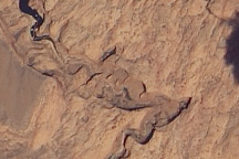
Acquired on May 23, 2010, this natural-color image shows the Colorado Plateau’s Rainbow Bridge, a natural sandstone arch, casting a slim shadow to the northwest.
Published May 30, 2010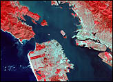
Fog forms along the Pacific coast when warm air currents meet chilly waters welling up from the deep ocean.
Published Sep 11, 2012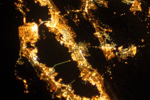
City lights reflect some of the landscape features that determine urban growth patterns in the region.
Published Oct 21, 2013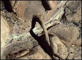
This spectacularly detailed Ikonos satellite image from July 7, 2003, could almost be mistaken for an aerial photo. Rainbow Bridge is at the upper right of the scene, casting its shadow on the rugged canyon below.
Published Aug 6, 2004