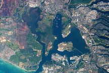
An astronaut captured this photo of the historic stretch of southern coastline of Oahu.
Published Dec 7, 2009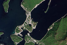
The remote port of Dutch Harbor, Alaska, is the launching point for a June 2010 NASA research cruise into the Arctic.
Published Jun 15, 2010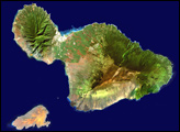
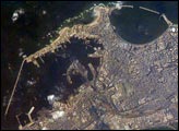
Founded by Alexander the Great in 331 BC on the Mediterranean coast of Egypt, Alexandria became a center of trade and learning in the ancient world. he Eastern Harbor was the main port in the Middle Ages. This detailed image taken by Space Station crew members using an 800-mm lens provides a view of the modern port facilities in the Western Harbor, where wharves and many moored ships can be detected.
Published May 31, 2004
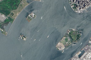
A pair of modest oyster flats turned into two of most important islands in the United States.
Published Mar 20, 2016
On September 25, 2002, astronauts aboard the International Space Station viewed Easter Island, one of the most remote locations on Earth. Easter Island is more than 2000 miles from the closest populations on Tahiti and Chile—even more remote than astronauts orbiting at 210 nautical miles above the Earth. Archaeologists believe the island was discovered and colonized by Polynesians at about 400 AD. Subsequently, a unique culture developed. The human population grew to levels that could not be sustained by the island. A civil war resulted, and the island’s deforestation and ecosystem collapse was nearly complete.
Published Oct 6, 2002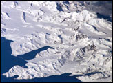
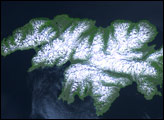
There is no permanent human base on South Georgia Island, a British territory in the South Atlantic Ocean that lies 1,300 kilometers east of the Falkland Islands. The crew of the International Space Station captured this image of the rugged and isolated landscape of the northern shore of the island. The first recorded explorer to land on the island was Captain James Cook aboard the HMS Resolution in 1775. He mapped part of the coastline, but was discouraged by the thick ice cover, lack of vegetation, and steep mountains. Mt. Paget, the highest peak, rises to 2,934 meters (9,625 feet) above sea level, and the island supports 161 glaciers. Cook named the southernmost point of the island “Cape Disappointment” when he realized he had not reached Antarctica.
Published Oct 17, 2005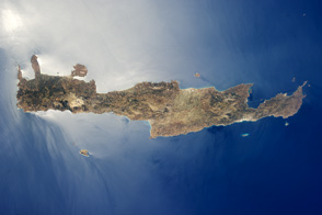
Crete is the largest and most heavily populated island of Greece.
Published Aug 15, 2011
Attu Island is so far west, it’s actually in the Eastern Hemisphere. It is the westernmost of Alaska’s Aleutian Islands, even farther west than the Hawaiian Islands.
Published Jul 5, 2006