
The city of Seoul (originally known as Hanyang) has been the capital of Korea for more than 600 years. This astronaut photograph illustrates the Seoul urban area at night. Major roadways and river courses (such as the Han River) are clearly outlined by street lights, while the brightest lights indicate the downtown urban core (center of image) and large industrial complexes. One such complex is located at the far left of the image and occupies an island in the Yellow Sea. Very dark regions in the image are mountains or large bodies of water. Nighttime images have been used extensively in urban climate and urban growth research to map the extent of urban (bright) versus rural (dark) regions.
Published Jan 10, 2005
The roofs of Barcelona’s buildings appear as a widespread pink swath on the Mediterranean coastal plain, between forested hills (dark green, top) and the sea. The Llobregat River enters the view top center, cuts through a canyon in the hills and historically constructed a broad, convex delta south of the forested hills. Channelization of the Llobregat River to control flooding has encouraged development of the delta for a variety of urban and agricultural land uses. Barcelona’s airport is located in the central portion of the delta, while the western portion is used for intensive agriculture (light green areas).
Published Jul 5, 2004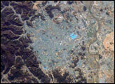
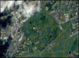
Kwangju (or Gwangju) Metropolitan City is the fifth largest urban area in South Korea. With a population of 1.4 million people, it is a major economic and cultural center for the southern portion of the country. The city is located in a geographic basin with high mountains to the east—the mountain of Mudeungsan has a peak elevation of 1,140 meters (3,740 feet)—and more open plains to the west.
Published Apr 30, 2007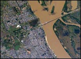
The Paraná River, in the center of the view, has been the principal transportation artery of central South America since the times of early colonization. Consequently, the river gave rise to the growth of port cities such as Argentina’s second city, Rosario (bottom center), now a major industrial center (pop. > 1.1 million). Rosario is the center of a vibrant local agricultural economy—intensive agriculture is visible on the left margin of the view. As such, Rosario is one of the key cities in South America’s MERCOSUR common market (Argentina, Brazil, Paraguay, Uruguay). Other cities have expanded along the river bank, especially northward (for example, Capitan Bermudez, top left).
Published Nov 7, 2005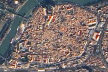
Acquired December 15, 2009, this true-color image shows Avignon, France, immediately east of the Rhône River. Walls surround the city’s historic center. Industrial-style buildings predominate in the southwest and southeast.
Published Jan 24, 2010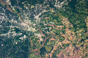
The landscape is defined by hills to the west and by the river running through it, not to mention the oxbow lakes that water left behind.
Published Jun 10, 2013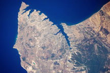
The urban landscape of Sevastopol, on the Ukrainian coast of the Black Sea, is featured in this astronaut photo from August 5, 2009.
Published Aug 24, 2009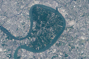
Tucked inside a bend of the Chao Phraya River, a green oasis stands in the heart of an urban jungle.
Published Mar 1, 2015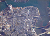
Originally known simply as “Amboy,” “Perth” was added to the name in honor of the Earl of Perth when the city became the capital of East Jersey in 1686. Together with South Amboy across the Raritan River, both cities are collectively known today as “the Amboys.” Perth Amboy is currently undergoing urban renewal and redevelopment to resume its former status as a resort destination.
Published Mar 3, 2008
Greenwich is situated on the south shore of a sharp bend in the River Thames, just southeast of the City of London and is part of Greater London. Here is located the world famous Royal Observatory where the Prime Meridian, dividing East and West Longitude, was defined by international agreement in 1884.
Published Jul 29, 2001