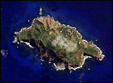
On September 25, 2002, astronauts aboard the International Space Station viewed Easter Island, one of the most remote locations on Earth. Easter Island is more than 2000 miles from the closest populations on Tahiti and Chile—even more remote than astronauts orbiting at 210 nautical miles above the Earth. Archaeologists believe the island was discovered and colonized by Polynesians at about 400 AD. Subsequently, a unique culture developed. The human population grew to levels that could not be sustained by the island. A civil war resulted, and the island’s deforestation and ecosystem collapse was nearly complete.
Published Oct 6, 2002
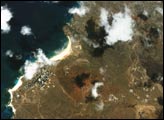
The small Puerto Rican island is a natural reserve that has been nicknamed the “Galapagos of the Caribbean.”
Published Feb 28, 2016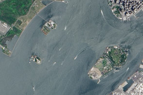
A pair of modest oyster flats turned into two of most important islands in the United States.
Published Mar 20, 2016
An unnamed isle in Canada’s Nunavut Territory is the leading contender for this island superlative.
Published Feb 22, 2015
The ghostly white shapes northeast and immediately southwest of Wrangel Island are sea ice. Over the course of the satellite record, Arctic sea ice has advanced and retreated past Wrangel Island many times. From 1979 to 2000, the sea ice edge at the end of summer generally fell somewhere in the vicinity of Wrangel Island, but this is not the first summer when the sea ice edge has retreated well north of the island.
Published Aug 29, 2008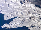
There is no permanent human base on South Georgia Island, a British territory in the South Atlantic Ocean that lies 1,300 kilometers east of the Falkland Islands. The crew of the International Space Station captured this image of the rugged and isolated landscape of the northern shore of the island. The first recorded explorer to land on the island was Captain James Cook aboard the HMS Resolution in 1775. He mapped part of the coastline, but was discouraged by the thick ice cover, lack of vegetation, and steep mountains. Mt. Paget, the highest peak, rises to 2,934 meters (9,625 feet) above sea level, and the island supports 161 glaciers. Cook named the southernmost point of the island “Cape Disappointment” when he realized he had not reached Antarctica.
Published Oct 17, 2005
In the western Pacific Ocean, a new volcanic island that formed in the shadow of Nishino-shima has merged with it. The island has doubled in size as the eruption continues.
Published Apr 4, 2014
The island once looked very different from how it does today.
Published Apr 16, 2017
On May 10, 2007, a large human-caused fire broke out near the island’s only city, Avalon. Before it was contained five days later, the fire scorched 4,800 acres.
Published Nov 11, 2007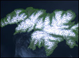
Attu Island is so far west, it’s actually in the Eastern Hemisphere. It is the westernmost of Alaska’s Aleutian Islands, even farther west than the Hawaiian Islands.
Published Jul 5, 2006
Named Isla de Aves in Spanish, (meaning “Island of the Birds”) Aves Island lies west of the Lesser Antilles in the Caribbean. It provides a nesting site to green sea turtles (Chelonia mydas) and, of course, birds. Because the abundant bird droppings, known as guano, could be used in fertilizer and gunpowder, guano miners worked on the island until they depleted the supply. Since its discovery by Europeans, likely in the late 16th century, Aves Island was subsequently claimed by several European nations. The island is currently claimed by Venezuela, although disputes about ownership of the island, and the surrounding exclusive economic zone in the Caribbean, continue today.
Published Jun 19, 2006
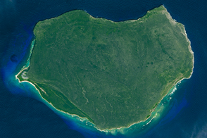
The most interesting geology lies just offshore and below the water line of this Northwest Australian island.
Published Aug 3, 2015
This natural-color image shows Henrietta Island, with a smooth, dome-capped surface and a rugged coastline, illuminated by low-angled sunlight.
Published May 3, 2009