The clay, sand, and other minerals coated in thick, viscous bitumen are a source of oil, economic growth, and environmental concern.
Published Nov 30, 2011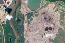
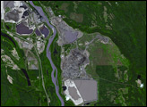
Earthy open-pit mines and tailings ponds line the Athabasca River where it flows through the world’s largest field of oil sands.
Published Nov 5, 2009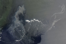
On July 14, 2010, a silvery gray patch of oil stretched across the Gulf of Mexico about 80 kilometers (50 miles) southeast of the tip of the Mississippi River Delta.
Published Jul 15, 2010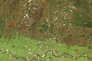
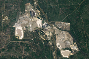
Swampy areas in the West Siberian Basin are some of Russia’s most important sources of crude oil and natural gas.
Published Oct 18, 2016
Floods and new infrastructure have long since separated the distinctive bend in the river that was portrayed by landscape painter Thomas Cole in 1836.
Published Oct 15, 2017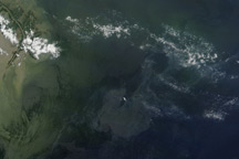
Regions of heavy oil in the Gulf of Mexico are visible in this photo-like image from June 7, 2010.
Published Jun 8, 2010

Acquired May 1, 2011, this natural-color image shows the James River completely filling the river valley near Jamesville, South Dakota.
Published May 3, 2011
Trees have long been cherished here for timber and for the colors they bring to “the Fall Rhapsody.”
Published Oct 24, 2020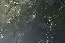
Between scattered clouds, silvery-gray streaks of oil remained visible in the Gulf of Mexico on July 19, 2010.
Published Jul 20, 2010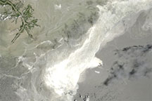
Acquired June 25, 2010, this natural-color image shows the oil slick in the Gulf of Mexico.
Published Jun 26, 2010
Acquired April 2, 2011, and February 27, 2011, these natural-color images show rising waters on the Kuiseb River, which flowed all the way to the Atlantic Ocean for the first time in decades.
Published Apr 12, 2011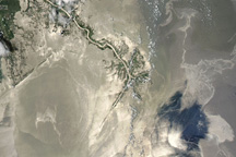
The oil spill in the Gulf of Mexico appeared large and sprawling in this natural-color image from May 25, 2010.
Published May 26, 2010