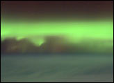
As geomagnetic storms cause beautiful displays of aurora across the United States, astronauts onboard the International Space Station also have the opportunity to take a look. Green colors of the aurora are dominant in this image captured by a digital still camera on October 4, 2001.
Published Nov 11, 2001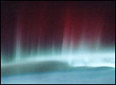
Reds and greens dominate this view of the northern lights as photographed from the Space Shuttle in May 1991.
Published Apr 15, 2001
With much of their time committed to construction of the International Space Station, astronauts and cosmonauts are also beginning their first scientific studies. The Destiny Laboratory just joined to the International Space Station includes the best optical quality window ever flown on a human-occupied spacecraft. The window will eventually host a number of remote sensing experiments that will use a special rack system, the Window Observational Research Facility or WORF, for mechanical and electrical support (Eppler et al. 1996). Until the WORF is complete in June 2002, astronauts are photographing the Earth’s surface as part of an early project, Crew Earth Observations.
Published Feb 16, 2001
The Curiosity rover on Mars looked up and saw home on the horizon.
Published Mar 9, 2014
Red sprites, short-lived flashes caused by intense lightning, are rarely captured on camera.
Published Jul 10, 2012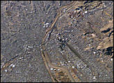
This image of the El Paso-Juárez area on the U.S.-Mexico border is the 100,000th photograph of Earth that astronauts have taken from the International Space Station. It was taken on January 26, 2004, by Expedition 8 crewmembers. The Rio Grande can be seen meandering through the area, forming the boundary between the sister cities of El Paso, Texas and Juárez, Chihuahua. North is to the right in this image, and the setting sun has cast the east side of the Sierra Juárez and Franklin Mountains into shadow.
Published Feb 9, 2004
On July 19, 2013, NASA spacecraft got not one but two rare and unique views of Earth from opposite ends of the solar system.
Published Jul 24, 2013
Astronaut photography of the Earth from the International Space Station has achieved resolutions close to those available from commercial remote sensing satellites—with many photographs having spatial resolutions of less than six meters. Astronauts take the photographs by hand and physically compensate for the motion of the spacecraft relative to the Earth while the images are being acquired.
Published May 6, 2002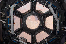
Primarily designed to give astronauts a way to see the outside of the ISS, it also provides stunning panoramic views of Earth and space.
Published Feb 20, 2010
From one million miles away, the DSCOVR satellite returned its first view of the entire sunlit side of Earth.
Published Jul 21, 2015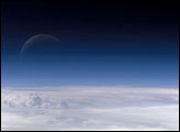
Atmospheric gases scatter blue wavelengths of visible light more than other wavelengths, giving the Earth’s visible edge a blue halo. At higher and higher altitudes, the atmosphere becomes so thin that it essentially ceases to exist. Gradually, the atmospheric halo fades into the blackness of space. This astronaut photograph captured on July 20, 2006, shows a nearly translucent moon emerging from behind the halo.
Published Feb 2, 2007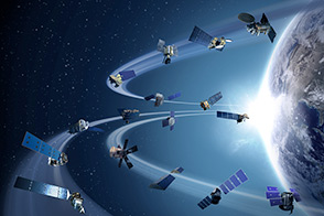
Sixteen operating satellites monitor Earth. Four more are scheduled to launch in 2014.
Published Jul 5, 2013