Images related to Hurricane Katrina

Hurricane Katrina Arrives
Image

Hurricane Katrina Arrives

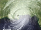
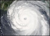
With winds of 135 miles per hour, a powerful storm surge, and heavy rains, the category 4 hurricane pounded the U.S. Gulf Coast, triggering deadly flooding.

Published Aug 30, 2005

Image of the Day Atmosphere Severe Storms

Hurricane Katrina
Image

Hurricane Katrina

Published Aug 25, 2005

Severe Storms

Hurricane Katrina
Image

Hurricane Katrina

Published Aug 26, 2005

Severe Storms

Hurricane Dennis
Image

Hurricane Dennis

Published Jul 10, 2005

Severe Storms

Hurricane Katrina
Image

Hurricane Katrina

Published Sep 2, 2005

Severe Storms

Hurricane Katrina
Image

Hurricane Katrina

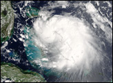
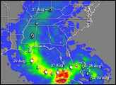
“Katrina is comparable in intensity to Hurricane Camille of 1969, only larger,”warned the National Hurricane Center on Sunday, August 28, 2005. By this time, Hurricane Katrina was set to become one of the most powerful storms to strike the United States, with winds of 257 kilometers per hour (160 miles per hour) and stronger gusts.

Published Aug 28, 2005

Atmosphere Land Water Severe Storms

Hurricane Frances
Image

Hurricane Frances

Published Aug 31, 2004

Severe Storms

Tropical Storm Noel
Image

Tropical Storm Noel

Published Nov 2, 2007

Severe Storms

Hurricane Jimena
Image

Hurricane Jimena

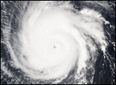
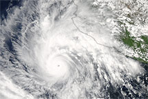
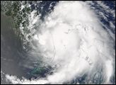
Hurricane Jimena was heading west-northwest toward Mexico’s Baja Peninsula on August 30, 2009, when the Moderate Resolution Imaging Spectroradiometer (MODIS) on NASA’s Aqua satellite captured this image.

Published Aug 31, 2009

Atmosphere Water Severe Storms