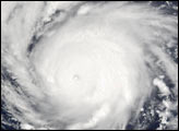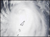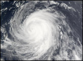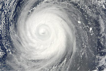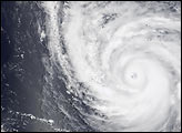
With sustained winds at 145 knots (167 miles per hour), Super Typhoon Fengshen reached Category 5 hurricane status—the most severe hurricane status—on Friday, July 19, 2002. This image was acquired by the Moderate Resolution Imaging Spectroradiometer (MODIS) on Monday, July 22, 2002, when the super typhoon was several hundred miles east of Iwo Jima at the southern tip of Kyushu, Japan. The storm is churning the sea into 35-foot waves, and winds have been gusting up to 170 knots (196 miles per hour). In this image, the storm occupies a rectangle roughly 1000 kilometers wide and 1150 kilometers tall. If the western side of this storm were aligned with Nashville, Tennessee, it would cover the United States all the way east to the Atlantic Ocean, as far north as Akron, Ohio, and as far south as the Georgia-Florida border.
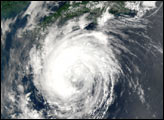
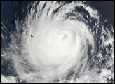
Fengshen has been tracking northwestward over the past 24 hours, and is expected to weaken only slightly as it makes its way toward Japan, which is still recovering from floods and wind damage caused by Typhoons Chataan and Halong, which hit the country the previous week.
Please note that the high-resolution scene provided here is 500 meters per pixel. For a copy of the scene at the sensor's fullest resolution, visit the MODIS Rapid Response Image Gallery.
Image courtesy Jacques Descloitres, MODIS Land Rapid Response Team at NASA GSFC