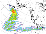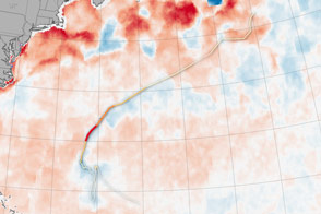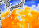

On land, the passage of a severe storm might be marked by fallen trees or swollen streams. In the ocean, a hurricane leaves a swath of cold water in its path. That trail of cold water marks the passage of Hurricane Bertha through the North Atlantic Ocean in this sea surface temperature image, taken by the Advanced Microwave Scanning Radiometer for EOS (AMSR-E) on NASA’s Aqua satellite on July 14, 2008. Water that is warm enough to fuel a hurricane—about 28 degrees Celsius (82 degrees Fahrenheit)—is yellow and orange, while cooler water is blue and white.
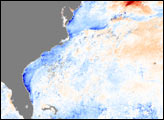
The warm water is pooled in three distinct regions. The largest of these regions extends east from Florida, Cuba, and Hispaniola. The Gulf Stream current is distinctly visible flowing north along the East Coast of the United States. The third region of warm water is isolated in the center of the image, separated from the rest of the warm water by the cool water left in Bertha’s wake.
This path of cold water was created by Bertha’s powerful winds. The wind churned the ocean, pushing sun-warmed surface water down and driving cool water from beneath to the surface. The swath of cold water follows the storm’s path north. Between July 3 and July 20, Bertha slowly tracked from the Cape Verde Islands off the coast of Africa, where it formed, across the Atlantic, gradually building and waning in strength. The storm curved north, skimmed past Bermuda, leaving the wake of cold water seen here, and then turned northeast until it broke apart over the chilly waters of the North Atlantic. Throughout its long lifetime, Bertha briefly reached Category 3 status, with winds approaching 195 kilometers per hour (120 miles per hour or 105 knots).
NASA image by Jesse Allen, using AMSR-E data processed and provided by Chelle Gentemann and Frank Wentz, Remote Sensing Systems. Storm track data provided by Unisys. Caption by Holli Riebeek.