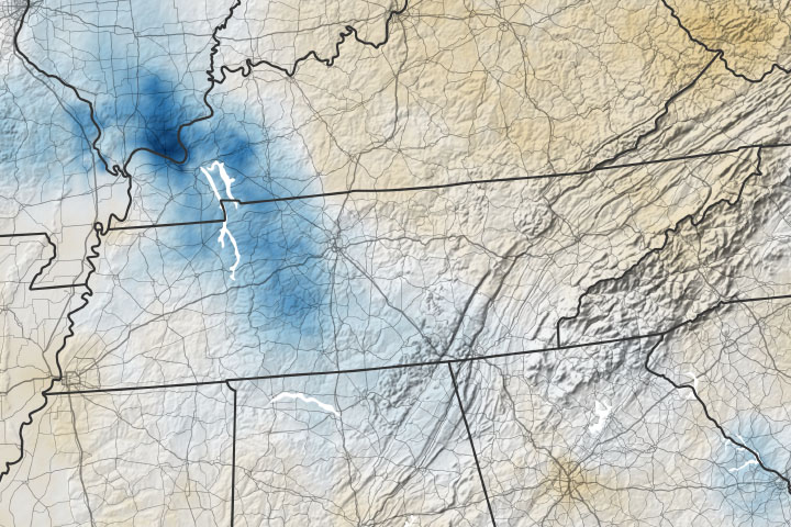
On August 21, 2021, a burst of severe and extremely localized rainfall led to catastrophic flash floods in Tennessee. In just 24 hours, 17 inches (43 centimeters) of rain fell on several towns in northern and central portions of the state, according to the National Weather Service. The total broke the state record for rainfall in a day (previously 13.6 inches). Floodwaters rose quickly on local streams and rivers, wiping out roads and communication lines and killing at least 22 people.
Flash floods occur when persistent heavy rain causes small creeks, channels, and streams to swell rapidly. They are very difficult to capture with scientific satellite imagers because such floods tend to arise and dissipate quickly, while most NASA satellites only pass over most regions once or twice a day and cannot see through clouds. But other types of measurements can give us a hint at the severe rainfall.
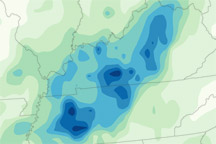
The map above shows changes in the moisture in the top meter (3 feet) of soil from August 20 to 21, 2021, before and after the severe rainstorms. The map was built with data from the Crop Condition and Soil Moisture Analytics (Crop-CASMA) product. Crop-CASMA integrates measurements from NASA’s Soil Moisture Active Passive (SMAP) satellite and vegetation indices from the Moderate Resolution Imaging Spectroradiometer (MODIS) instruments on NASA’s Terra and Aqua satellites.
NASA Earth Observatory images by Joshua Stevens, using soil moisture data from Crop Condition and Soil Moisture Analytics (Crop-CASMA). Caption by Michael Carlowicz.