| The Basic Vegetation Map
One of the most basic types of land cover maps is the vegetation map. This map shows a breakdown of general vegetation types over large areas of land, and typically contains over a dozen categories that include deciduous forest, broadleaf forest, farmland, and desert shrub. The physical processes behind the spectral signatures of green vegetation are well understood. Chlorophyll in plants absorbs red light and other visible wavelengths from the sun for use in photosynthesis. The cell structure in plant leaves generally reflects near-infrared light. The more foliage a plant has, the more these wavelengths of light will be absorbed and reflected.
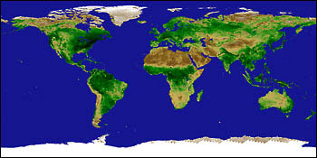
To determine what type of vegetation exists over a given region, researchers take a satellite image of the infrared and red light emitted and reflected from a plot of land. They then compare the two types of light at each point (pixel) on the image. The difference in intensity between the two wavelengths tells them the density of vegetation present. If the difference is at its highest value, then the vegetation at that pixel is likely to be rather dense and may contain rain forest, for example. If it is at its lowest value, then the vegetation is probably sparse, which could be indicative of a desert. Defined values between these two extremes indicate other categories such as farmland. Once every pixel on a given image is accounted for, scientists can lay the pixels out on a map and color code the results. They then take periodic ground test measurements of the areas mapped to verify the exact type of vegetation there. next: The Problems in Uncovering Land Cover
|
Land Cover Classification |