On the next part of our journey the DC-8 traversed the tropical Pacific Ocean. I have always been deeply fascinated by this part of the atmosphere. The tropical Pacific Ocean lies over very warm water heated by the sun, and it is often considered to be the “firebox” of the atmosphere, the place where vast amounts of energy enter the atmosphere and drive many major features of our weather and climate.
The plane crossed two very important boundaries in the atmosphere. We encountered the first one, the Intertropical Convergence Zone (often abbreviated as the ITCZ), as our DC-8 passed 10 degrees north of the equator on the flight from Kona, Hawaii, to Pago Pago, American Samoa. The ITCZ is usually located north of the equator in Northern Hemisphere summer, and right along the equator in winter. It stands as the great meeting place between the Northern and Southern Hemispheres. Air circulates within each hemisphere in a few months, but it takes roughly a year for air to be mixed between the hemispheres by crossing the ITCZ.
I expected our measurements would see very different concentrations of pollutants as we crossed this boundary, with higher concentrations in the north than in the south. And indeed we did. The amount of carbon monoxide (CO), a major pollutant arising from all forms of combustion, dropped abruptly. But the change wasn’t as big as I expected. Other pollutants behaved the same way. The air was very clean in the northern tropical Pacific, so the North-South contrast was muted.
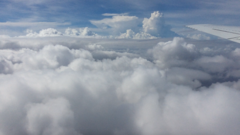
The DC-8 flies among the developing showers of the ITCZ along the equator on the flight from Kona to American Samoa. Credit: Steven Wofsy, Harvard University
But I was in for a surprise a short while later. After we had passed the ITCZ, we turned the plane to the east and travelled along the equator. Every time the DC-8 dipped down below about 10,000 feet, we saw strangely high pollutant levels, including carbon monoxide and indicators of fresh burning, such as benzene and fine particles of smoke and soot. Here we were in the midst of fresh pollution, in the Southern Hemisphere where air is supposed to be so clean. We were more than 6,000 miles from the nearest land!
Maybe I should not have been surprised. Our atmospheric computer models had actually predicted that we would see these chemicals. According to Junhua Liu, the scientist at Goddard Space Flight Center who generated the forecast, the chemicals originated in South America where fires are set each August to remove weeds and crop residues from agricultural fields and to clear trees in the forest. The goal of our ATom mission is to find out where, and how, pollutants reach the most remote parts of the planet, and we had certainly found a big input in a very surprising place, where very few people have been able to sample before us.
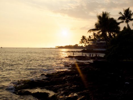
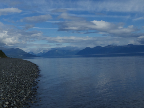
We encountered the second boundary, the South Pacific Convergence Zone (SPCZ) on the next flight of the DC-8 from Pago Pago to Christchurch, New Zealand. American Samoa is a lush tropical island with craggy mountains covered in jungle and clouds and generally mild weather. All that was about to change in a hurry.
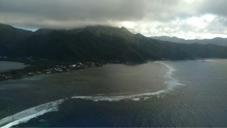
The DC-8 climbs steeply away from the tropical island of American Samoa, with its mountains covered by warm clouds. The next land we see on the ATom mission is the South Island of New Zealand, deep in winter. Credit: Bruce Daube, Harvard University.
First we came upon the SPCZ. The SPCZ is a powerful, nearly stationary feature of the South Pacific, where cold winter air from the south meets the warm, humid air from the tropics. This front is a continuous band of heavy rain and winds. Embedded in the front is the subtropical jet stream, which had winds over 200 knots (230 miles per hour) and powerful turbulence at its core the day that we were there. Our safe passage and successful sampling required close coordination between the crew and the meteorological team of ATom — Paul Newman of NASA’s Goddard Space Flight Center on the plane, and Eric Ray of NOAA’s Environmental Systems Research Laboratory on the ground.
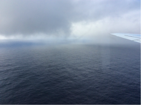
The leading edge of the SPCZ. The DC-8 sampled down to 500 feet over the ocean at the northern edge of the SPCZ, finding a view more likely to be seen from a boat than a jet aircraft. With stormy weather ahead, we took our samples quickly and climbed as high as we could. Even at the ceiling of the DC-8’s altitude, we still encountered rough flying conditions. Credit: Steven Wofsy, Harvard University
Finally, we approached the South Island of New Zealand. What a contrast to American Samoa! The mountains were clothed in snow. The valleys had been made into tidy farms with wind breaks and agricultural fields. One of the scientists on board, Róisín Cammane of Harvard, thought the farms looked just like her home country in Ireland, although the mountains are bigger.
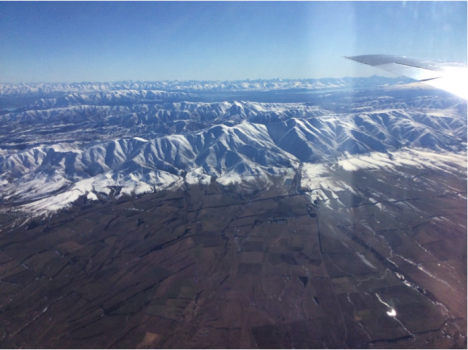
Coastal mountains on the South Island of New Zealand, near Lauder Station, overlooking agricultural lands. Credit: Steven Wofsy, Harvard University
We made a low pass over the famous observatory at Lauder, with more than 50 years of measurements of the atmosphere. A team of scientists at New Zealand’s National Institute of Water and Atmospheric Research (NIWA), led by Dave Pollard, run the station. The station is part of NASA’s Total Carbon Column Observing Network (TCCON) and hosts a spectrometer that looks at the sun and, by looking at the part of the light spectra that is known to be absorbed by carbon dioxide, measures the total amount of carbon dioxide in the atmosphere. TCCON was designed and implemented for NASA by Paul Wennberg of Caltech to help calibrate the Orbiting Carbon Observatory satellite.
Lauder Station of New Zealand’s National Institute of Water and Atmospheric Research (NIWA). The DC-8 made a low pass over this site in order to help calibrate the TCCON measurements of carbon dioxide, which are made by looking at the sun with a spectrometer housed in the domed structure at the top of the image. Credit: Bruce C. Daube, Harvard University, from the NASA DC-8
Our aircraft measurements provide a direct link between the measurements that scientists make by sampling air at the ground and the measurements made by satellite and the TCCON looking at sunlight. On the airplane we measure samples of air, just like sampling on the ground, but we can take those samples along most of the path from the ground to the top of the troposphere, getting the total amount of carbon dioxide for the whole column, which the TCCON sites measure. My group have done these type of measurements all over the world, starting in 2004, and we have been to Lauder five times before, but never have we had such a clear day as we did on this flight.
Correction: Aug 19. The Goddard weather forecaster was misidentified in the original post. It has been corrected in the text.
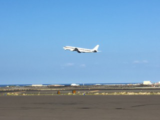
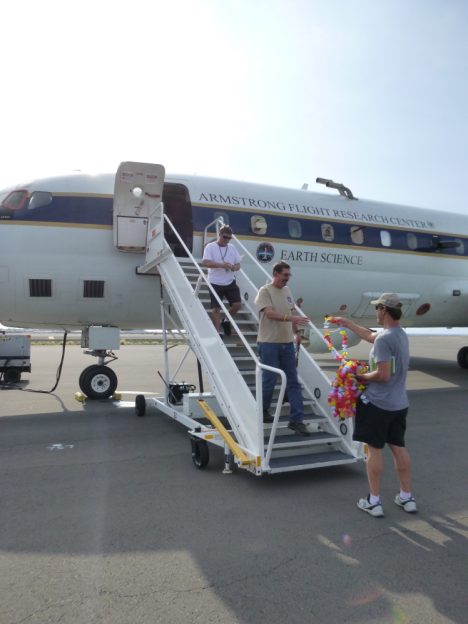
The DC-8 departs Kona for American Samoa (credit: Dave Jordan)
The other day I had a unique and difficult experience. I was on the tarmac at Kona International Airport, Hawaii, and I watched the DC-8 take-off, with all my colleagues, our crew and my instruments on board. This wasn’t planned, and no, I hadn’t just missed my flight.
Somewhere between California and Alaska I caught a seemingly innocuous cold. Then somewhere between Alaska and Hawaii this cold stopped me from being able to equalize the pressure in my ears. On a normal flight this can be extremely painful and can risk lasting damage to the ear drum and hearing. On a flight where you simulate take-off and landing 8 times … well you can imagine.
We’d been told in our safety briefings to mention ear discomfort to the crew should it arise, so after waiting a little bit too long because I wanted to tough it out and not cause a fuss (very ill advised, don’t do that) I mentioned this to the crew. They immediately showered me with all kinds of medication to help and techniques to equalize pressure and reduce pain. This, and being able to ask the pilots to pause and level out for a bit when we were going down, got me through a few more descents, but the pain became really unbearable in the end.
The project principal investigator, Steve Wofsy, and crew came up with a plan to do our last descent in stages, leveling out every few hundred feet to make it less painful for me as well as being a new and excellent way for some of the instruments on board to sample the atmosphere. By leveling out for five or ten minutes at a time, they could collect samples at unique altitude levels for later comparison to see the vertical structure of the atmosphere here. I’m so glad it worked out that way.
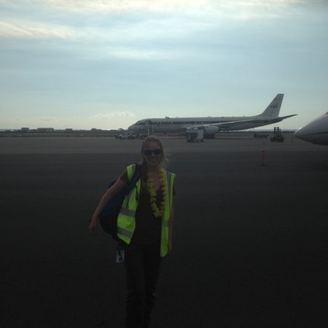
Me having successfully landed in Hawaii with both eardrums intact (credit: Maximilian Dollner, University of Vienna).
We had two hard down days in Hawaii before flying to Samoa and I felt sure I’d recover in time. I thought things would clear up on landing, but they didn’t, and I spent the next morning in urgent care, getting prescriptions for antibiotics and steroids. I slept a lot and tried every trick in the book to clear my ears. However, nothing was improving.
Just in-case, I trained two of my colleague on running my instruments, and hatched a plan with my supervisor back in Colorado that if I couldn’t take the flight on Saturday, I’d fly commercial to New Zealand the next day and catch up there to do some maintenance and hand over properly to my colleague who’s scheduled to fly the second half.
I desperately wanted to be on that flight to Samoa. The last 14 months of work have been all preparing for this. I love the excitement of the flights and watching the data come in, the camaraderie among the team, seeing all these new and different places. I also hate the idea of not being strong enough for something, it’s a bug-bear of mine. Above all, this mission is too important to mess up.
And that’s when I realized, the mission really is too important to mess up. And that means, if its not sensible to fly, I do not fly. If I flew with bad ears and the pilots had to divert the course every instrument on that plane loses data. If I arrive in Samoa with a burst ear drum, not only is it much harder to deal with, but I’m a greater risk flying on subsequent missions because of the weak spot.
If I don’t fly, actually I’m proud to say, my instruments do pretty fine without me now. We did a lot of work to ensure they automatically cope with all the pressure changes and other challenges of the flights, and it has paid off. And the features I notice along the way, well I get so darn excited about them I tend to explain them to anyone who’ll listen, so my colleagues can spot a lot of them for me after five flights together now. We have a chat link set up with the DC-8 while it flies, so for each of the two flights I’ll miss I’ll be online on the ground diagnosing any issue that come up for the instruments and helping out my colleagues who are kindly running them for me.
I tried until the last minute, even during the pre-flight meeting to equalize my ears, although I’d told the science and mission directors the previous evening that if there wasn’t a dramatic improvement I would not be flying. They didn’t equalize. In fact they still haven’t. My team are in American Samoa, preparing to fly to New Zealand and I’m in Hawaii on strict medical advise not to fly for three more days. I won’t even catch up in New Zealand. Instead, I will fly back to Colorado as soon as my ears allow.
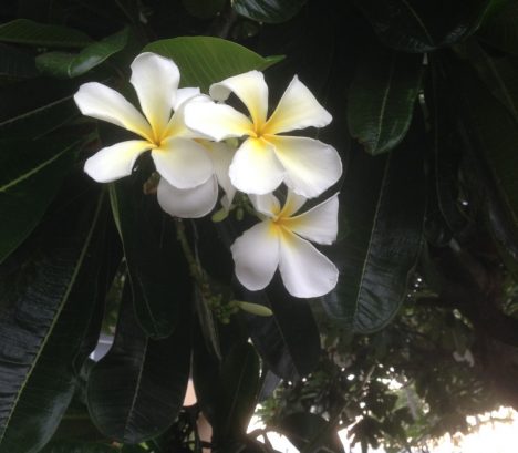
Plumeria flowers on Kona, Hawaii (credit: Christina Williamson)
As science gets to be more about successful collaborations, given the large scale and complex nature of the questions we’re now addressing, being a good scientist becomes more about good team work. This is no place for personal heroics or thinking you’re not expendable. Sometimes, a little humility and discretion can go a long way.
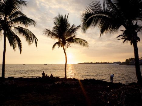
Sunset on Kona, Hawaii (credit: Christina Williamson)
Christina Williamson blogs regularly about the ATom Mission and other adventures in atmospheric science at christinajwilliamson.wordpress.com and tweets as @chasingcloudsCW.
The DC-8 preparing to leave Anchorage, Alaska (credit: Christina Williamson).
We had a gently warm morning for takeoff to Hawaii, with sun peaking through the clouds. Getting above the clouds we had spectacular views of snow capped peaks. We made a missed approach at Cold Point, population 109 at the last census. Low clouds prevented us from seeing too much there visually, but through the instruments we saw that many chemical species were very low, perhaps because the air had been recently cleared by rain.
Mountain views leaving Anchorage, Alaska (credit: Christina Williamson).
Missed approach at Cold Point (credit: Christina Williamson)
We then flew over the Kodiak Archipelago, which I was told back in Anchorage is the place people go when Alaska feels too crowded! It looked very remote and intriguing.
From there it was pretty much a straight shot down the pacific to Hawaii, where we landed on the largest island, Kona. We passed through a ship track at one point, where we can clearly see the plume in lots of instruments, including the number of aerosol particles that I’m measuring. Other than that it feels quite featureless. It’s funny to go out and purposefully measure “almost -nothing”. It’s not nothing, its the atmospheric background and there’s always stuff going on, but its the kind of stuff I’ll only be able to see once I look at a lot of data together, finding patterns over space or correlations with other measured values. It may not be the most exciting data to report here, but in terms of our long-term understanding of atmospheric processes and rigorous testing of global climate models, it’s absolutely key.
We keep the cabin cool while we fly as it’s good for the instruments (although less comfortable for the humans). We knew Kona would be very humid, and if we just landed and opened the doors to let humid air in to condense on cold instruments we’d be in trouble, so we added heat in the last descent to stop this from happening.
It was indeed hot and humid when we landed. The ocean was a beautiful bright turquoise as we flew over it and the volcano was shrouded in mist. Our logistics manager had arrived before us and came onto the plane greeting each of us with traditional leis to welcome us.
Leis handed out by Dave Jordan (NASA AIMES) as we land in Kona, Hawaii (credit: Karl Froyd)
Wandering along the shore that evening to have dinner watching the sunset over a palm fringed beach it felt surreal that we had breakfasted in Alaska and seen so much in-between.
Palm trees on the shore on Kona, Hawaii (credit: Christina Williamson)
Christina Williamson blogs regularly about the ATom Mission and other adventures in atmospheric science at christinajwilliamson.wordpress.com and tweets as @chasingcloudsCW.
The title of this post is borrowed from Phillip Pullman’s prequel to his Dark Materials trilogy. I loved these books as a child, and by happy coincidence ended up studying for my masters at the college on which Jordan College in the novels is based. The reference to journeys northward and parallels with searching for particles struck me as appropriate.
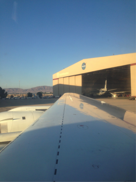
View from the DC-8 toward the NASA-Armstrong hangar in Palmdale, California (Credit: Christina Williamson).
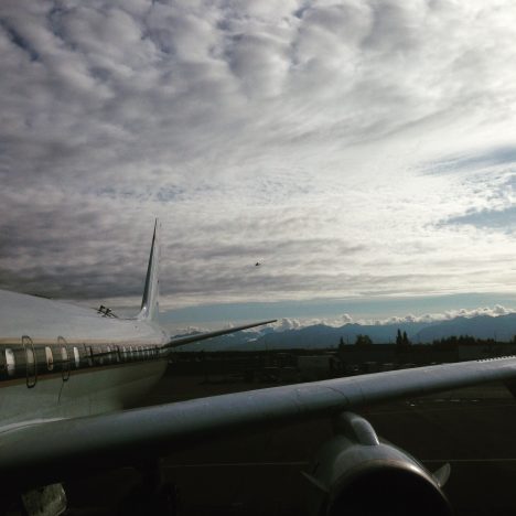
Pre-flight in the Californian desert heat at 4am and a sunrise take off felt very far removed from out aim of 80 degrees north. There were however two key differences from our last flight to the equator and back. One, I was the only one of my three-person-team on board (we’ve always flown two of us before). Two, we were not coming back (at least not for a while). This is the first leg of the round-the-world part of the journey. The plan was simple: Anchorage, Alaska, via as-far-north-as-we-can-get-with-the-fuel-we-have.
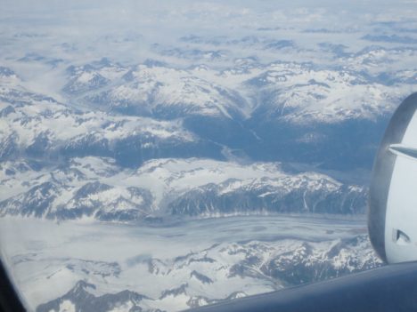
Flying up the west coast of the U.S. and into Canada was stunning. We passed above beautiful mountain ranges and volcanoes over Oregon, Washington and into Canada. We stayed at high altitude to conserve fuel for the northern part of the leg.
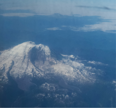
Mount Rainer viewed from the DC-8 flying from Palmdale, California to Anchorage, Alaska (Credit: Christina Williamson).
Mid-way above Canada we found ourselves above a heavy blanket of cloud. We could see when we passed through the jet stream, because the winds there are very strong. This jet-stream of fast moving air around the arctic acts to isolate (to a degree) the air masses north of it from those at mid-latitudes. This is part of what makes it so interesting to study arctic air. We’re interested in how much pollution from lower latitudes affects things here, and to see what happens in the atmosphere where it’s much cleaner than most places we get to sample. People have observed lots of new particle formation (where small aerosol particles form directly in the atmosphere, changing from the gas phase into a solid or liquid phase) in the artic in summer time before, and I was interested to see if we would also witness this process. I need to analyze the data before I can really say what we sampled on this flight.
Once through the jet stream we found a hole in the clouds and managed to descend. We were in the arctic, flying over broken sea ice. It was beautiful and serene. Just ice and water below and white clouds above. We saw lots of melt pools of bright blue water on the ice.
Flying over the arctic on the DC-8 (Credit: Christina Williamson).
Flying over the arctic on the DC-8. The dark and bright blue patches are melt pools in the ice (Credit: Christina Williamson).
Somewhat reluctantly we found another hole in the clouds and ascended, to stick to our brief of scanning the atmosphere, and to conserve fuel. It’s interesting to sample at all altitudes, but heading so far north and being low over the ice was very exciting for all on board. The farthest north we got was 79 degrees N, definitely a record for me.
We then headed west towards Alaska, making a missed approach over Dead Horse. The land here was interesting, lots of pools of water, and strange hexagonal patterns in the grass the I’m told are caused by permafrost melt.
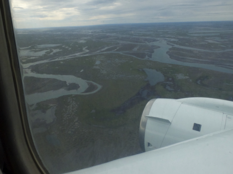
Views over Dead Horse, Alaska. (Credit: Christina Williamson)
We then came farther south over Alaska, making another missed approach at Fairbanks, and eventually landing in Anchorage, where the mountains, ocean, and cool, damp air were there to greet us as a refreshing change from the Californian desert.
Me and the DC-8 having arrived in Anchorage. (Credit: Max Dollner, University of Vienna).
We had a hard down day in Anchorage. Most of this was spent servicing the instruments and processing data from the flight, but I also found some time in the evening to take a short stroll to a beautiful beach and have dinner with colleagues looking over a lake on which water-planes were frequently taking off and landing. It’s definitely a nice bonus that we get to see beautiful places like this while working.
Views during an evening stroll in Anchorage, Alaska (Credit: Christina Williamson).
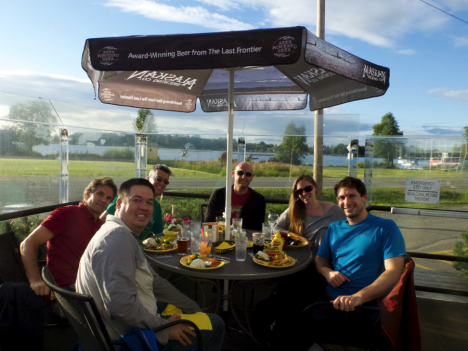
Some of the ATom science team having dinner in Anchorage, Alaska. From left to right: Eric Apel (UCAR), Kirk Ullmann (UCAR), Jeff Peischl (CIRES/NOAA), Joseph Kaitch (CIRES/NOAA), Christina Williamson (CIRES/NOAA), Maximilian Dollner (University of Vienna).
Christina Williamson blogs regularly about the ATom Mission and other adventures in atmospheric science at christinajwilliamson.wordpress.com and tweets as @chasingcloudsCW.
I have been looking forward to the second leg of the ATom mission since I first worked up the plan, collaborating with the others on the leadership team and with the flight operations crew from NASA’s Armstrong Flight Center. It would start in the hot, high desert in Palmdale, California, and journey to the high Arctic, dipping low over the floating sea ice near the North Pole, before ending in Anchorage, Alaska. What an opportunity to observe the extremes of Earth’s weather and climate, atmospheric composition, and ecosystems!
We flew this mission on August 1. The contrast between the environments could not have been more dramatic. We started our work at 4 a.m. so that the DC-8 could take off before the searing heat of the day — forecast to be 110 F (43 C). A few hours later we were in one of the coldest, most remote parts of the Northern Hemisphere. It was stunning and beautiful. But also sobering, because both places are experiencing huge impacts from the warming climate and from air pollution carried there on the winds.
In the High Desert: Fires, Urban Pollution, and a Solar Farm
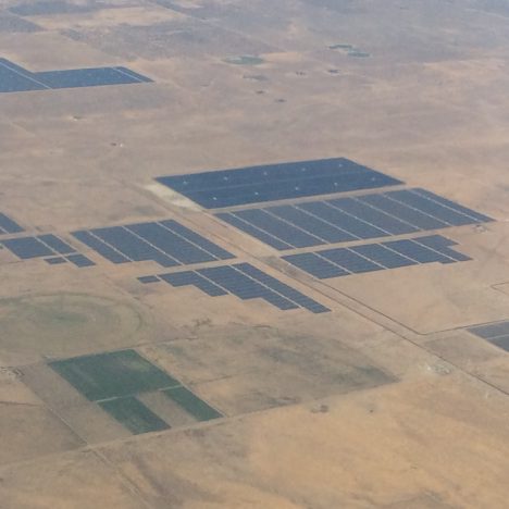
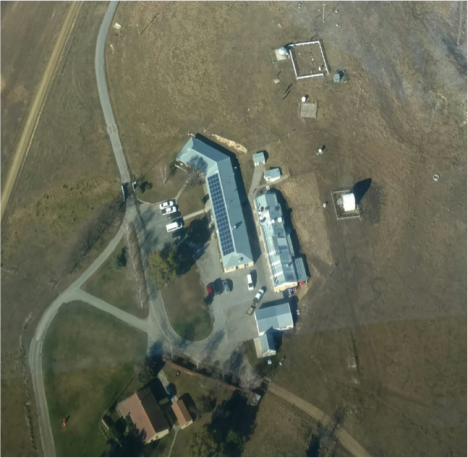
Solar farm in the desert north of Palmdale, CA. Credit: Steve Wofsy
The desert near Palmdale was particularly forbidding when ATom started up. Large fires in the nearby mountains blanketed the region with choking smoke as ash sifted down from the sky. Increasingly frequent fires are an expected consequence of climate warming in this area. Even after the fires died down, the atmosphere over the desert was hazy with urban pollution originating in the Los Angeles Basin. It was unnerving to be in the midst of these events.
But as we departed the desert, I could see huge solar and wind farms generating carbon-free electricity. This sight was much more hopeful. If we apply our minds and resources to the problem, we can make significant progress in slowing the increase in atmospheric CO2 and generate new economic value at the same time. It is a long process though—a generational challenge.
In the High Arctic: Melting of Floating Ice, and More Fire Influence on the Atmosphere
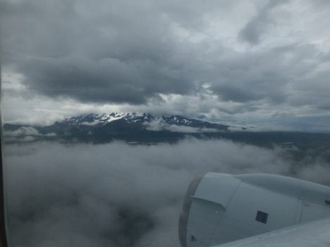
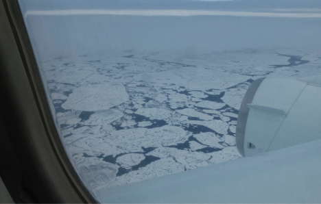
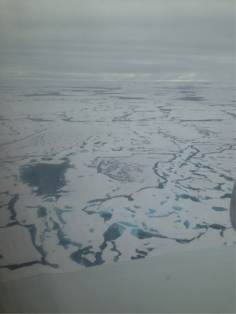
We flew for several hours in the DC-8 and finally reached our destination at 80o N, the top of the world. The weather was very unfavorable at first, with heavy cloud cover obscuring the surface and making it unsafe for the DC-8 to fly low. I was really worried that we would miss the chance to sample the atmosphere and see the fabled ice cap. Then we found breaks in the clouds, and we could see the broken ice floes at the surface. We flew down to 500 feet (150 m) for a close encounter.
These images are deeply disturbing. Here we are, almost at the North Pole, and the floating ice is broken up, with dark water between flat slabs that are covered with dark covered melt ponds. Dark features accelerate melting of the floating ice by absorbing sunlight and soaking up the warmth that radiates from the atmosphere (“longwave radiation”). As melting increases the areas of open water (called “leads”) and melt ponds, more energy is absorbed and melting is accelerated. We can see with our own eyes the phenomenon known as “positive feedback”: warming and melting feed on each other, accelerating the disappearance of the ice cap.
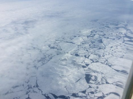
Our first glimpse through the clouds of the floating ice at 79 N on 1 August 2016. Credit: Steve Wofsy
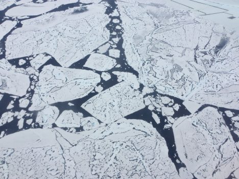
Close-up view of ice floes at 79 N from 500 feet. The dark features on the ice are melt ponds, and the dark areas of between the floes are open water of the Arctic Ocean. The floes are very flat, signifying “first year ice”. Credit: Steve Wofsy
The flatness of the ice is also shocking. It is “first year ice” that formed last winter from the freezing of open water. We never saw any of the lumpy “multi-year ice”, which used to survive for many years when the climate in the high Arctic was colder than it is today. A lot of ice that we saw at 80o N yesterday will be gone by the end of the melting season in September. I don’t know if we will have an open ocean so close to the pole this year, but the ice that we saw certainly didn’t look very resilient.
The coverage of floating ice has shrunk dramatically in the Arctic ocean over the past 35 years (that’s just ½ of my age!), as shown in the chart below. In the 1980s, the whole Arctic ocean was ice-covered at the end of winter, and about half remained ice-covered at the end of the melt season. In the 2000s, this picture abruptly changed. There was no longer full coverage at the end of winter, and, by the record low year of 2012, late summer ice cover had been reduced to only one half of its former extent. That is a drastic change to the global environment, in just the time since my children were born.
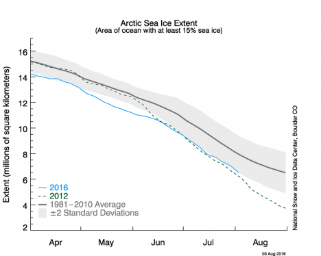
Chart of Arctic Sea Ice Extent showing the summer melt season for 1981-2010 average (black), record low in 2012 (dashed green), and this year 2016 (blue). Credit: National Snow and Ice Data Center
In 2016, as you can see from the chart, we are on track to match that record low ice extent from 2012. The high Arctic really is the “point of the spear” when it comes to climate change. But very few of us get to see the ongoing changes with our own eyes. The scientists and crew flying on the DC-8 are really privileged to have witnessed this phenomenon first hand, even though it was unsettling to observe it.
The atmosphere at 80o N had very low levels of pollutants. But once we turned around and headed for the Alaskan coast, our instruments reported strong signals from the huge fires burning the boreal forest in Siberia. This pollution was pervasive for hundreds of miles before we made landfall at Deadhorse, Alaska—the start of the Trans-Alaska oil pipeline. Viewing the huge oil and gas facilities in Deadhorse certainly gave a contrasting impression compared with the solar farms in California!
Volcanoes on Our Route – Mother Nature is Really Amazing
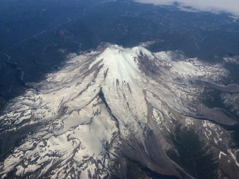
Mount Rainier, Washington. Credit: Steve Wofsy
I will close on a more positive note. On the way from California to the Arctic, we flew by the stunning volcanoes of the Northwest U.S. These iconic forms remind us of the beauty and overwhelming power of Mother Nature. Our Earth is really awe inspiring, and worth protecting.
Photo Credits: Steven C. Wofsy, on board the NASA DC-8 in the ATom project, August 1, 2016.
