By Eric Lindstrom
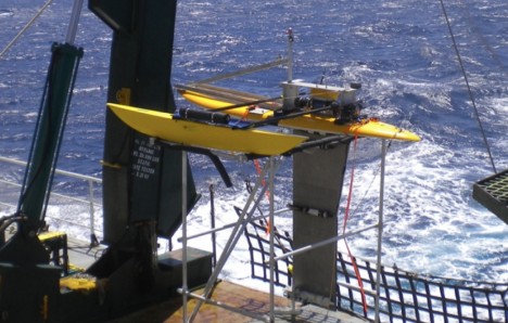
The Surface Salinity Profiler from University of Washington’s Applied Physics Lab, shown here while it was being tested at sea, is now deployed on R/V Thalassa.
The SPURS experiment involves not only sea-going oceanographers but modelers, and of course, remote sensing scientists using satellite data. As part of the daily posts from R/V Knorr I will go into more detail on the role of the models and satellite data in the overall scientific enterprise. I will profile the modeling teams and their interaction with the ship-based team during the voyage.
Numerical models of the ocean, run on supercomputers, can provide high-resolution animations of the physical environment for us sea-going scientists. In order to actually simulate the environment, the models need to take in data from the expedition and make sure the model solution is one that best fits the available data. This process is called data assimilation. (You are more familiar with data assimilation in models than you think – daily weather maps are the result of models and forecasts are done using data assimilation into sophisticated models of atmospheric physics.)
An objective of SPURS is to provide a high-resolution, near-real-time stream of data that can be assimilated into ocean models. Because the ocean is so big and complex, and our at-sea capacity to measure it so puny, we rely on ocean modeling and data assimilation to help us interpret the environment. The model results can be used in planning work at sea and to diagnose the balance of salinity in the upper ocean. The observations are essential to locking model results into the real oceanographic environment. The model is essential to estimating things we cannot measure directly and expanding upon the interpretations provided by the observations.
In SPURS, we hope that we scientists at sea and those ashore can collaborate through the exchange of data and model results. This was not possible as late as a decade ago. Now we have Internet at sea and can exchange information and results for daily planning and analysis.
I will discuss the synergy of models and data much more during posts from the ship in September.
SPURS as an International Enterprise
The SPURS experiment involves a number of expeditions and nations working in cooperation at the single location in the North Atlantic.
The French R/V Thalassa is in the SPURS region now with one U.S. team aboard from University of Washington’s Applied Physics Laboratory. I will give more details in future posts.
Follow-on U.S. expeditions will use R/V Endeavor from University of Rhode Island to follow-up the measurements of R/V Knorr. The first of these two expeditions is in the spring of 2013 and will service SPURS equipment that requires maintenance after 6 months at sea. That expedition will also do more of the “feature” characterization. A second expedition in the fall of 2013 will recover all the moored equipment and gliders, among other duties.
A Spanish cruise is also planned for next spring. The details of this expedition will be subject of a post.
What’s up next?
Next up will be the loading of R/V Knorr on 5 September and a media event at 10 am that day. We set sail on 9/6 at 10 am.
By Eric Lindstrom
As I mentioned in my previous post, our cruise will depart from Woods Hole, MA on September 6. Roughly, it will take eight days for our ship, R/V Knorr, to transit from Woods Hole to the SPURS central mooring site at 25N, 38W, the saltiest spot in the subtropical North Atlantic. Then we will spend several days planning for and deploying sophisticated moorings bristling with instrumentation, which will remain in place for 12 months and provide a broader view of the mooring area’s physical properties, which will be our starting point for future, more localized ship-borne measurements. Details of moored instrumentation and how the approximately 5-kilometer (3-mile) long moorings are deployed will be the subject of my shipboard posts.
Testing of a SPURS Langrangian float in Puget Sound in August 2012.
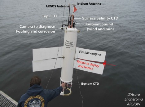
With moorings successfully in place, we will deploy an extensive array of Lagrangian (free-floating) instruments. There will be Argo floats that park at 1 km (0.6 mi) depth and periodically measure temperature and salinity measurements in the upper 2 km (1.2 mi) of the water column. We’ll also use surface drifters that measure surface temperature and salinity and the velocity of the upper ocean. We’ll deploy several kinds of gliders that collect upper ocean temperature and salinity data along pre-programmed tracks. There will also be specialized profilers for measuring the temperature and salinity fine structure to help us understand mixing processes. We will deploy and use these during the middle weeks of the expedition, while leaving many instruments that will continue to collect data for six months to a year.
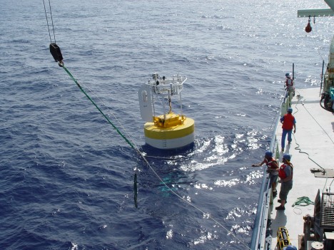
A SPURS mooring being tested.
Another aspect of the cruise is devoted to understanding the role of eddies (the swirls of ocean waters) in the circulation and the distribution of salinity. The cruise plan calls for finding and mapping an interesting front or eddy feature in some detail. My posts from the ship during that time will highlight the identification of the feature and how we chase it and measure it, and I will also describe the implications of our observations.
The expedition will wrap up with final checks of the instrumentation to be left behind, recovery of temporary deployments, profiles of temperature and salinity for cross-calibration of instruments and other duties that may arise.
We will use many of the kinds of instruments that are already deployed in a sustained, basin-wide observing system (surface drifters, Argo floats, moorings, and volunteer observing ships). What we will do with SPURS is expand the area we study, observe it for a longer time, and dig into the details. NOAA will be a strong partner throughout the SPURS mission, and I will tell you how we collaborate in future posts.
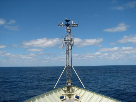
This mast measures ocean surface fluxes.
The chief scientist for the R/V Knorr leg of the SPURS experiment is Ray Schmitt from Woods Hole. Ray is funded by the National Science Foundation to examine salinity processes. NSF is an exceptional partner in SPURS – sharing the burden of ship support and helping to provide the scientists and equipment to study the smallest scales of variation of salinity. Their role is SPURS will also be detailed during the expedition posts.
All of the scientists and technicians involved in SPURS on R/V Knorr have numerous and specialized roles to play for the entire expedition to be successful. I plan on describing their personalities, work at sea, and motivations in future posts.
After approximately three weeks on site at the salinity maximum in the subtropical North Atlantic, R/V Knorr will make for Punta Delgada in the Azores Islands to turn over the ship to the next scientific party (not related to SPURS). It will take about 3 days at full speed to reach the Azores, where the ship is due on 9 October.
In my next post I will describe some of the shore-based and international collaborations that support SPURS.
Until then, smooth seas!
By Eric Lindstrom
On September 6, a bunch of NASA-funded scientists, and me among them, will depart on an expedition across the North Atlantic Ocean to study salt concentration levels of seawater. But why do we want to spend six weeks at sea measuring ocean saltiness? Hopefully, over the coming months you will come to understand the motivation and get caught up in the action through this blog.
My name’s Eric Lindstrom and I am a program scientist for NASA’s Physical Oceanography program. My normal work involves developing and managing NASA’s Physical Oceanography research program. I gave up my career as a seagoing oceanographer to become a manager in our offices in Washington, D.C. However, marrying satellite observations with sea-going oceanography has been a long-term goal of NASA and that’s why I am about to go back to sea, to participate in a research project that merges both fields.
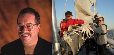
Eric Lindstrom, NASA’s Physical Oceanography program scientist and SPURS blogger.
In September I’ll embark on the Research Vessel Knorr, leaving from Woods Hole Oceanographic Institution in Massachusetts toward Punta Delgada, Azores (Portugal), where we plan to arrive on October 9. This cruise is part of a multi-year research project called Salinity Processes in the Upper Ocean Regional Study (SPURS for short) and, in the U.S., it’s a collaboration of NASA’s Earth Science Division and partners funded by the National Science Foundation Division of Ocean Sciences and the National Oceanic and Atmospheric Administration.
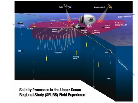
An illustration depicting the instruments SPURS will deploy in the saltiest spot of the Atlantic Ocean.
I plan, over the coming weeks, to introduce the science, the scientists and technicians headed to sea, their individual contributions to the field campaign, and the amazing technology that makes it all possible. But first you need to know some background and what to expect in future posts.
Oceanographers are keenly interested in the smallest variations of the salinity of seawater. How salty the water is from one place to another is one of several key factors in determining the density of seawater – and it’s density variations and wind what drives ocean circulation. Density is determined by the water’s temperature, salinity, and depth in the ocean. We’ll discuss the processes that change temperature and salinity in later posts (as they are at the core of the SPURS field work). In general, the effects of the sun and the atmosphere on the surface of the ocean lead to variations in the temperature and salinity that drive the ocean circulation, which in turn provides energy back to the atmosphere in the form of water vapor, impacting weather (i.e., changes in rainfall frequency and distribution) and climate. I intend to delve into many of the details of this interaction with my posts from R/V Knorr.
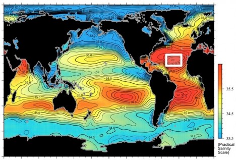
A global map of the salinity, or saltiness, of Earth’s ocean surface, showing the spot in the North Atlantic Ocean where the SPURS research cruise is headed to.
In June 2011, NASA launched a new Earth-observing instrument to measure the surface salinity of the ocean from space. The instrument, called Aquarius, is flying on the Argentine satellite SAC-D and delivers a global map of ocean surface salinity on a weekly basis. This data give unprecedented insight into the variations of the surface salinity of the ocean. While, sea surface temperature has been regularly measured from space for over 30 years, salinity has been a much more difficult measurement to make from space. The question of how do we measure salinity from space is a great subject for later in this blog – I plan on writing about it when we have a quiet day at sea!
A primary objective of SPURS is careful examination of the processes that change salinity in the upper ocean – so we can better interpret the variations in salinity seen globally from space. This year’s focus is on a high-salinity region – as is characteristic of the mid-latitude open oceans around the globe. These are relative “ocean deserts,” where there is much more evaporation than precipitation leading to saltier surface waters. In the future (circa ~2015), a second SPURS campaign hopes to examine processes in one of the “wet” sectors of the ocean, where rain far exceeds evaporation, freshening surface waters. Other processes affect salinity including advection (water circulation) and vertical mixing. I will discuss these in some detail during the cruise, because they are the subject of specialized measurements and have a big impact on our interpretation of salinity variations.
The study of salinity variations in the ocean from all the accumulated ship-board measurements of surface salinity over the last 50 years has revealed interesting trends. It turns out that the high salinity regions of the subtropics have been tending saltier and the low salinity regions of the rain belts have been tending fresher. This can be interpreted a “fingerprint” of an accelerating water cycle – something we expect in a warmer world where the atmosphere holds more water vapor. Models show that this state, roughly speaking, leads to drier dry places and wetter wet places – just what the salinity of the ocean seems to suggest. Unless there is an alternative explanation: that’s where oceanography comes in – the conclusion about the water cycle is only true if purely oceanographic explanations for the trends in surface salinity are ruled out. In other words, is there some other combination of oceanographic processes that could explain why salty places appear to be getting saltier and fresher places fresher? SPURS is ultimately about answering such questions, so we can use global salinity data and ongoing monitoring of salinity as a powerful tool in diagnosing global environmental changes.
And that’s all for today. In my next post, I’ll explain more about the scientists involved in SPURS and more about the posts you will receive from sea during September and October.
