For just a brief moment, I find myself finally able to pause and reflect on just how far we, Operation IceBridge, have come as a team and a project. It was roughly one-and-a-half years ago when we were first tasked by NASA Headquarters to bring the P-3, a four-engine turboprop aircraft, to McMurdo Station for new Antarctic operations.
At that time, I didn’t even remotely comprehend the task that lay ahead for me. It would take an infinite supply of persistence and tenacity, as it would be, to overcome new challenges, hurdles, processes, logistics, requirements and doubt, with a government shut-down thrown in the mix. As I write these words, I am sitting in the Crary Science Building, at McMurdo Station, on Ross Island, glancing out of the third floor panoramic window. Many of my team members sit across from me as we wait in anticipation for a storm to blow in. McMurdo Sound, Mt. Discovery, the Royal Society Range and Black Island look back at me, reminding me that I am in Antarctica with my entire team of 31 people.

IceBridge project manager Christy Hansen stands with the crowd greeting the NASA P-3 when it arrived in Antarctica on Nov. 16, 2013. Credit: NASA / George Hale
In just three weeks, our entire team has arrived safely, taken multiple training classes, established and constructed four GPS ground stations and unpacked several thousand pounds of cargo. We’ve also conducted two GPS ground truth surveys (one via helicopter operations to the infamously harsh and windy Black Island), landed the NASA P-3 in Antarctica for the very first time, performed a safe and successful check flight and completed five full science missions. Our U.S. Antarctic Program contacts have told us that we’ve accomplished more in these three weeks than many science projects do over a whole multi-month season in McMurdo. I am so proud to be a part of this amazing team, and watch in awe how each of our instrument teams and flight crew stop at nothing to excel at what they do, and to project professionalism and respect for others around them. I work with a team of super stars. I love it when a plan comes together.
But how does one get a team of 31 people to the ice, land a NASA scientific airplane in Antarctica for the very first time, and conduct daily scientific airborne surveys based from a runway made of sea ice? Yes, I said sea ice. How does one meet the needs of both the IceBridge instrument teams and aircraft office, while also establishing credibility, trust and respect with the National Science Foundation (NSF), the federal agency responsible for managing and leading the U.S. Antarctic Program (USAP)? And let’s talk about cargo. How do you get 35,000 pounds of cargo to the most remote and harsh continent on the planet? Not quickly. How do you take care of a complex aircraft on an airfield made of ice in extremely cold temperatures without a hangar while following strict environmental protection regulations and the rules of the airfield outlined by the airfield manager? What order do you do all of this in, when does the planning start and what are the milestones and decision points?

A view of the NSF administration building in McMurdo. Credit: NASA/Jefferson Beck
How do you go from initial concept to actual flight operations in Antarctica?
A year-and-a-half ago, we met with NSF’s Office of Polar Programs to first discuss our interest in deploying to McMurdo in 2013’s austral summer season. We described our scientific and mission objectives, which included bringing our own aircraft to the ice with us. To request approval to bring a large team of people and a large aircraft to the ice demands building credibility with multiple organizations, showing strong scientific value, financial responsibility, safety, realistic success criteria, and an understanding of resource limitations and management.
Bringing one’s own aircraft to the ice, especially without skis, demands a thorough understanding of risk and risk mitigation, and strict adherence to the unique operations protocols of operating an aircraft on the ice. The unique environment and quickly-changing weather required us to establish a relationship with SPAWAR (Navy weather experts) and the 109th Airlift Wing of the Air National Guard who helped us understand the weather, manage communications protocols and build our flight operations safety criteria.
Once the big picture plan, milestones and risk mitigation strategies were established with NSF, we were introduced to their logistics and operations team, the Antarctic Support Contract (ASC). Approximately one year out from our current deployment, we began planning the details that would help better define our IceBridge team footprint on the ice, and the resources we would need from ASC and NSF to ensure our science teams and flight crew could be supported.
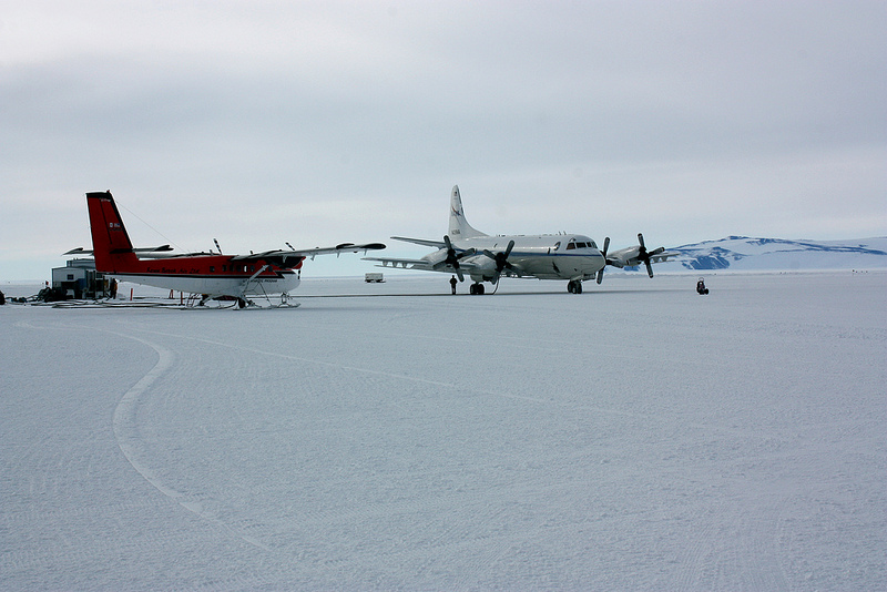
The NASA P-3 and a Kenn Borek Air Twin Otter in the fueling area at McMurdo Station’s sea ice airfield. The ski-equipped Twin Otter is more characteristic of aircraft seen at McMurdo. Credit: NASA / George Hale
It took many phone calls, teleconferences, and emails to make all of this happen. In fact, so much time was spent with my ASC planning team, I felt as though we were all old good friends from years past. We worked out details ranging from deploying personnel to the ice and ensuring all of their needs were met, to routing our 35,000 lbs of cargo halfway around the world via ship and plane and expecting everything to arrive in McMurdo, intact, a few days before we did.
Even more complex was establishing an operations plan that would support our NASA P-3 and its flight crew on the ice, allowing them to service and maintain the aircraft in harsh conditions. To give an idea of how to make this work, the air crew’s day began at 4 a.m. to support a 9 a.m. takeoff – reflecting the time needed to get to the runway, set up the aircraft ground support equipment used to warm the plane slowly, preserving the condition of the runway and allow time for the instrument operators to power up their equipment.
These five hours were followed by an eight hour science flight, which was followed by a two hour post flight routine. And this would start all over again the next day. To build confidence in this plan prior to our team arrival this season, three of us conducted a site survey last year to research and understand the operational environment of an airfield built on sea ice. We established a solid relationship with the airfield manager and were able to build and plan based on input he had given us.
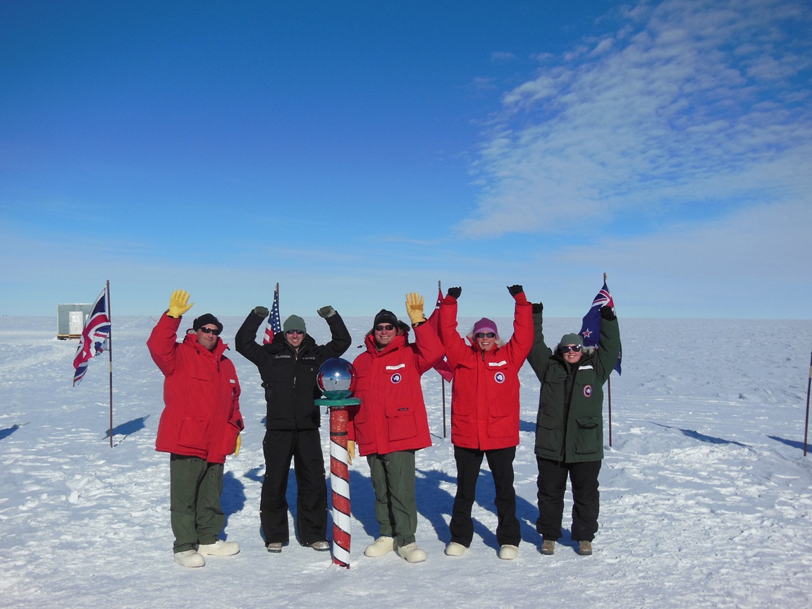
The IceBridge team and members of the 109th AW strike a pose at the South Pole during IceBridge’s Antarctic site visit in 2012. Credit: NASA / Christy Hansen
To be proud
Seeing this plan come to fruition has been one of the most rewarding aspects of my career. Our instrument teams have years of experience operating in polar environments, and they met new challenges, which made for extremely long days, and new hurdles to overcome, which they did with grace. When our P-3 aircraft landed on McMurdo’s sea ice runway on Nov. 16 , all of us who had deployed up to a week earlier watched in awe, full of emotion, as this historic moment was captured in time. The P-3 on final approach is a beautiful sight to watch, and I can’t remember ever having felt as honored and proud as I did greeting this crew who flew her and took care of her on her long journey across the globe, and onto NZIR, the sea ice runway, Ross Island, Antarctica.
Christy Hansen is Operation IceBridge’s project manager
One of the keys to IceBridge’s success is effective communication between every member of the team. But keeping in touch in the remote locales IceBridge operates from can sometimes be tricky. On plane there’s the intercom system routing through headsets and the radios and Iridium satellite communication devices aboard the P-3 allow the plane to communicate with someone on the ground virtually anywhere in the world.

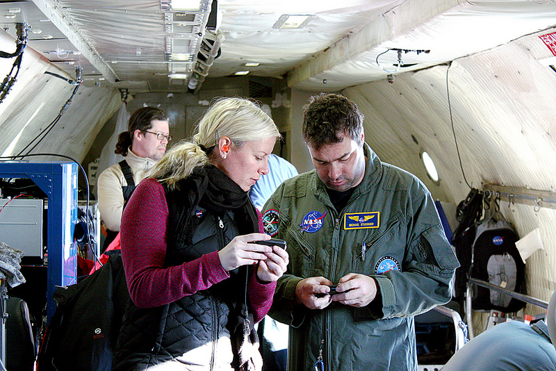
NASA P-3 aircraft technician Kevin Moore assisting IceBridge project manager Christy Hansen with the onboard Iridium satellite communications system during an IceBridge survey flight on Nov. 19, 2013. Credit: NASA / George Hale
But what about when the team is on the ground? When everyone is in the office or their rooms then email works. When away from the office, however, things get more complicated. Some areas have mobile phone coverage and it’s easy to take such a thing for granted these days. But in Antarctica, a locale where keeping in touch can literally be a matter of life or death, cell phone service is nonexistent. Even in a developed station like McMurdo the smartest of phones becomes nothing more than a pocket-sized music player, camera and entertainment device.
To meet the communications needs of people living and working in this often harsh environment, three tools some people might consider virtually obsolete: the landline telephone, the two-way radio and the pager.
Phoning It In
In the U.S., many homes are ditching their landlines. But in Antarctica they’ve never gone out of style. The backbone of the system is different, as calls are routed through the internet through the U.S. Antarctic Program’s office in Denver, but from the user’s perspective things are just as they were years ago.
Dorm rooms, offices and common areas all have telephones that can be used to call others on the station. IceBridge’s two main work areas, McMurdo’s Crary Lab and the team’s tents at the sea ice airfield, have telephones set up, allowing team members in these two locations to stay in touch.

One of the IceBridge team tents at McMurdo’s sea ice airfield. Inside the tent is a telephone, which team members can use to keep in touch with everyone back in McMurdo town. Credit: NASA / Jefferson Beck
Turn the Page
If you know someone is in their room or at the office, calling them on a landline phone is by far the quickest and most reliable way to contact them. However, it isn’t uncommon for team members to be out tending to instrument ground stations, unloading cargo or visiting the weather office for the latest forecast. In these cases, team members rely on a seemingly obsolete technology, the pager.
Before the widespread adoption of cell phones, personal pagers were fairly common. You’d call someone’s pager and enter your phone number and their device would beep, showing that you wanted to talk to someone. That person would then need to find a phone and give you a call. As inconvenient as this sounds the infrastructure for a paging system is more robust and less complicated than that needed for cell service.
IceBridge project manager Christy Hansen and project scientist Michael Studinger turn off their pagers before taking off on the Nov. 19, 2013, IceBridge survey flight. Credit: NASA / George Hale
The pagers at McMurdo Station are a little more advanced though, allowing for text pages and updates. By sending an email to a special address you can send a short message to someone’s pager and station management use the pager network to send out updates on weather conditions, something of vital importance in an environment like Antarctica.
On the Radio
Pagers and telephones work out great in town or between town and the airfield because nobody is terribly far from a phone at any time. But for people working outside of town, such as the people setting up instrument ground stations or the team who did the GPS survey of Black Island more than 20 miles away, an extra step is called for. This is where the two-way radio comes into play.
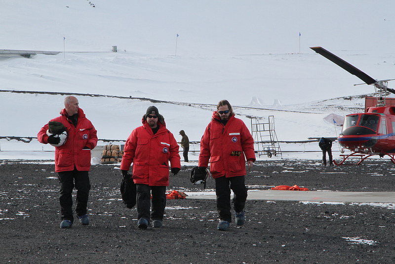
Members of the Airborne Topographic Mapper team return from an attempt at a ground survey mission conducted on nearby Black Island. Credit: NASA / Jefferson Beck
The VHF two-way radios used at McMurdo are a great way for widespread teams to keep in touch. Each radio can tune into one of a handful of channels dedicated for different purposes. IceBridge personnel communicate on the science channel, while shuttle drivers and airfield personnel would use different channels.
Putting It All Together
Although not as convenient as the average smart phone, the combination of land line telephones, pagers and two-way radios provides a way for people living and working in Antarctica to stay in touch with one another.
Before the first survey flight of an IceBridge field campaign can get under way a lot of things have to happen. Instruments have to be installed on the plane, researchers need to get into the field and ground stations need to be set up.
IceBridge’s McMurdo-based Antarctic campaign is the result of a year and a half of planning and preparation, all of which came together during a highly choreographed logistical dance that spanned more than a week and half of the globe.

NASA IceBridge team member Theresa Stumpf, right, and other passengers deplane upon arrival at McMurdo’s sea ice runway. Credit: NASA / Jefferson Beck
After a nearly four-week-long delay of a few weeks caused by the U.S. government shutdown, IceBridge went into high gear to finish up preparations for a shortened campaign. Before anybody could start on their way to Antarctica the mission’s scientific instruments needed to be installed on the P-3. Over a period of about two weeks, aircraft technicians and instrument team members at NASA’s Wallops Flight Facility in Virginia installed IceBridge’s scientific gear.
While this part of the team was finishing up their work at Wallops, a different group started their journey to the ice, flying to Christchurch, New Zealand, to receive their cold weather gear. While the rest of the IceBridge team was finishing up their work on the P-3 and traveling to the ice, this small group was busy laying the groundwork for the campaign by unpacking shipments, setting up GPS ground stations and preparing for a GPS ground survey of a nearby island.

Members of the Airborne Topographic Mapper team, Kyle Krabill, Robbie Russell, and John Sonntag, set up a ground station to help calibrate their GPS systems, a critical step to getting accurate data in the field. Credit: NASA/Jefferson Beck
With instruments installed and ground tests complete, most of the rest of the team packed up for the long flight south. Remaining behind were a handful of instrument specialists and pilots and crew for the P-3. Scientists and instrument operators would travel to Antarctica while the P-3 and its onboard instruments underwent a series of check flights.
With these final checks of the aircraft and instruments complete, the remaining few instrument specialists who remained behind followed the first and second waves of IceBridge personnel on commercial flights to New Zealand. This differs from the mission’s previous campaigns because normally scientists and instrument operators fly on the NASA research aircraft to the field location.

Operation IceBridge team members celebrate as the NASA P-3 aircraft taxis in from its first landing at McMurdo Station’s sea ice runway on Nov. 16th, 2013, Operation IceBridge pilots brought the aircraft over to its parking spot where it will rest between missions to survey Antarctic ice over the next few weeks. Credit: NASA/Jefferson Beck
The reason for the difference this time is that the transit from NASA Wallops to McMurdo Station in Antarctica would take several days. Going to Thule, Greenland, on the P-3 takes less than eight hours and traveling to Punta Arenas, Chile, on the DC-8 takes a 12 hour flight to Santiago followed by a shorter hop to Punta Arenas the next day. But this time, the P-3 would have to make stops in California, Hawaii and American Samoa, flying eight hours each day, before making it to the last stop before the ice in Christchurch.
The P-3’s arrival on Nov. 16 marked the completion of a long and complicated process and the beginning of a new and historic field campaign. For the first time ever a large, wheeled NASA aircraft would operate directly from Antarctica.
March 19, 2011
With three sea ice flights successfully behind us, and the airport being closed on the weekend, we had a day off from operations, and took advantage of the great activities that are coordinated by the Community Center here at Thule AFB. Today’s trip was a hike to the Ice Cap. About two dozen folks (mixture of Air Force Personnel, Danish Workers, and NASA IceBridge Team Members) piled into 4×4 trucks, and headed off base about 20 minutes drive. The last 5 minutes of the drive was “off-road” and we went as far as we could until 2 trucks got stuck in the snow. After a few minutes of shoveling and getting everyone back on sturdy ground, we took off for the 45 minute hike to the ice cap.
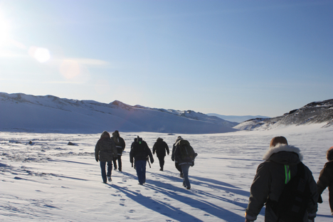
Heading out on our hike towards the Ice Cap. Credit: LCDR Woods
It was a pleasant walk, over mostly hard ground, with some areas of soft snow making for a good work out. We took several short breaks to stop and listen. The silence was incredible. There was no breeze, and absolutely no noise. No cars, no power poles, no animals (that we could see at least), just absolute silence. It was a very cool experience. We arrived at the area where the ice cap is exposed, and took some photos. The exposed blue, white, and brown banded ice was another breathtaking sight that I had never experienced before. After another few hundred yards down the trail, we arrived at the sledding hill with another amazing vantage point after climbing to the top.
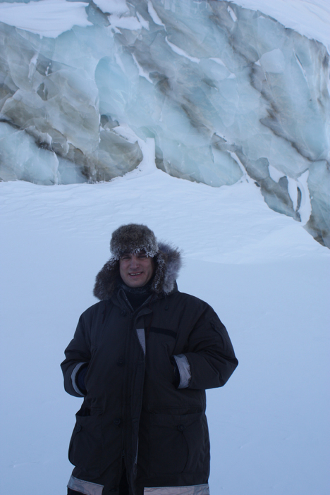
LCDR John Woods stands in front of the exposed ice cap, in which bands separate the different layers of ice. Credit: LCDR Woods
On the walk back, I found some fox tracks in the untouched snow that made for a great photo. There was no sign of the fox around, just for its left over paw prints in the fresh snow.
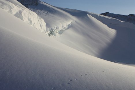
Fox tracks cut through the otherwise undisturbed expanse of the snow in front of the ice cap. Credit: LCDR Woods
We finished the walk with some Hot Chocolate and cookies, warming up and swapping stories about each person’s favorite part of the hike.
March 18, 2011
Today we flew again and went right by the North Pole! The NASA P-3 went 2 degrees to the left of it, if you picture looking straight down on top of earth!
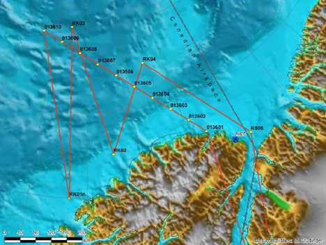
Sea ice mission ZigZag West along an ICESat orbit and some north-south trending transects that sample the gradient in sea ice thickness north of the coast of Ellesmere Island. Credit: NASA/Michael Studinger
The flights are usually about 7-8 hour missions so I woke up early and went to breakfast. After we got on our track over the sea ice, it was difficult to get good measurements because the clouds were so thick (the Lasers need clear skies). So the plane went to 1000 feet, which is very low. This made it exciting to look out the windows and see the sea ice below passing by really quickly. After we descended though, the laser altimeters began working better and collecting good data.
We landed around 1530 and I headed back to the North Star Inn to meet with a NOAA scientist Larry Connor. Dr. Connor wrote a paper looking at laser and radar altimetry measurements, so it was great getting to ask him questions about his work. In just a twenty-minute conversation with him, he was able to answer all the questions that were forming in my head from hours of reading and studying his paper. Tonight is my last night here so I went to the Top of the World club to say my goodbyes to all the engineers and scientists I got to meet during my trip to Thule AFB, Greenland.
I learned so much in my short week here; all the equipment onboard is so complex and it measuring features of the Arctic in order for scientist to study the change this environment is undergoing.
It was reassuring knowing that there are so many intelligent and hard working people looking at the poles and trying to understand the dynamics of them. I am excited to continue studying polar oceanography and hope to continually learn more as I pursue a higher education in graduate school.
