
Credit: NASA
The atmosphere was electric at Providence Landing Park in Lompoc, California as the first stage of an Atlas 5 rocket ignited in the distance on February 11, 2013.
Cheers erupted at 10:02 a.m. from the hundreds of people gathered there as the rocket rose, gathered itself, then surged into a perfect blue sky over Vandenberg Air Force Base. As the cheers subsided, it was surprisingly quiet for a moment as awe sank in, save for the patter of scores of cameras clicking in unison.
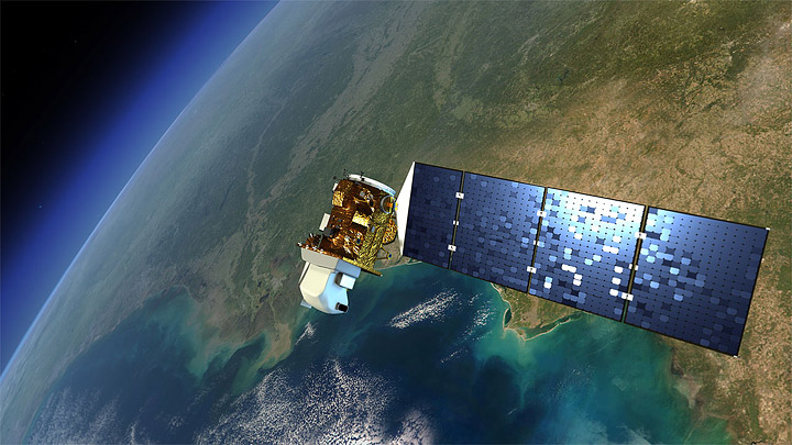
A full 30-or-so seconds later, the sound arrived. You could feel the roar in the ground. The Landsat Data Continuity Mission (LDCM), the latest satellite in the world’s longest-running series of Earth-observing satellites, was on its way to space.
At that moment, there was nowhere else in the world I would have rather been. Nowhere. I’m not prone to sentimentality, but the wonder I felt as I watched Landsat 8 shrink to a speck and disappear into the horizon was indescribably profound.
There is something simply overpowering about seeing an instrument of peace and knowledge burst beyond the bounds of gravity. If you ever have an opportunity to see a science satellite launch, don’t hesitate for a moment. Just go. You won’t be disappointed.
Good luck, Landsat-8. We have so much more to learn from you.

Credit: NASA

Photo Credit: VAFB
The computer system used to register visitors to Vandenberg Air Force Base wasn’t cooperating when I stopped by to get my ID approved yesterday. That meant I had plenty of time to chat with the two military police officers on duty. I learned two surprising things from them.
1) The base, particularly the beach area, has unexploded ammunition strewn around that make wandering off the roads a really bad idea. Before it was part of the Air Force, the Army used to use land that’s now part of the base for target practice. Decades later, unexploded mines, grenades, rockets, mortars, and bombs still have a habit of turning up. In 2010, for instance, the Bear Creek fire exposed a 200-pound explosive that specialists had to detonate (above).
2) Sharks are a problem as well. In the last few years, there have been two lethal shark attacks at Surf Beach near the base, the officers told me. I thought this might be a tall-tale they tell tourists, but the story checks out. In October 2012, a Great White mauled and bit a 39-year-old surfer in the upper torso. And in 2008, another Great White attacked a 19-year-old on a boogie-board, severing his leg. I went digging on the Air Force’s website, and they even have a picture of a mangled board from yet another incident in 2008 (below).
Normally, I’d jump at the opportunity to run on a beach and take a short dip in a place that’s as beautiful as this. But in this case, I’ll be sticking to rocket-watching for fun, thank you very much.

Credit: VAFB

The tower at SLC-3 where LDCM awaits final preparations for launch on Feb. 11 at 10:04 a.m. Credit: NASA/Ellen Gray
Count it among the things I never thought I would ever do in my lifetime—get up close to a loaded rocket that will carry a satellite into space in less than two days.
When your launch is on a Monday, the weekend is still busy, busy, busy. But Saturday morning two days before launch, a few of us working on the Landsat Data Continuity Mission (LDCM) project had a fantastic break. The United Launch Alliance (ULA) Launch Director invited us to come up to Space Launch Complex 3 where LDCM is currently sitting atop its Atlas V ride for a group photo.

Space Launch Complex 3 is where United Launch Alliance launches Atlas rockets. Photo Credit: NASA/Ellen Gray
It was a giddy group. As one of the mission science writers, I’ve only been working on LDCM for two years, but many on the project have been with the mission for much longer. Getting a chance to see the culmination of all the hard work of designing the mission and the instruments, getting them and the spacecraft built, tested and integrated into the LDCM satellite, prepping and loading the rocket–all of that was stretching up in one long column on this gorgeous California morning.
Space Launch Complex 3, or SLC (pronounced “slick”) 3, is set up on a bit of a hill on the south portion of Vandenberg Air Force Base. Downhill from the parking lot is the Pacific Ocean, the large unpopulated reason that U.S. spaceports are on coasts: if anything goes wrong the rocket lands in the water.
Mike Marasco and Debbie Fettig from ULA escorted us through the turnstiles into the restricted area and we walked up the short road to the tower that holds the rocket. Essentially the scaffolding that allows workers to access the rocket from the ground up, the tower doors were open so we could see the Atlas V and the white faring containing LDCM at the tippy-top.
We were maybe 100 to 150 feet away from the base of the pad. It was amazing to be so close. I saw Sarah Ryker, deputy associate director of the USGS Climate and Lands Use Change who has been working tirelessly on the future of the Landsat program and asked her how excited she was to finally see LDCM ready to go. She just grinned from ear to ear. It was a little surreal to finally see everything come together, she said, and beyond exciting.

The Atlas V rocket. The Atlas booster is the long shiny section. The Centaur upper stage is with white sections after it narrows, and just visible is the nose cone, or faring, where LDCM sits.
Photo Credit: Orbital/David Ward
We gathered for a bunch of photos with the base tower in the background. David Ward, flight insurance manager from Orbital Science Corp, had the only camera allowed on the site. Between shots we milled around a little, excitedly chatting about launch.
I grabbed Jerry Nagy, deputy observatory manager from NASA Goddard to point out the different parts of the rocket. The Atlas V booster makes up the long shiny, bottom portion and, right now, the lower section is filled with kerosene, the rocket propellant. It will be combined with liquid oxygen, to be fueled an hour and a half before launch, and ignited to provide an explosive 860,200 pounds of thrust. The liquid oxygen is so cold that after the Atlas is fueled, water from the air will condense and freeze on the outside of the tank, forming big chunks of ice. At launch, Jerry’s fingers wiggle, it will all shake off.
Jerry’s finger then moved upward to the white section of the column, pointing out the Centaur upper stage engine. Its fuel is liquid oxygen and liquid hydrogen that will ignite for its first burn ten seconds after the Atlas falls away, four minutes and eight seconds after launch. It will have a second burn, 70 minutes into launch to push LDCM into its preliminary orbit.
With the group photos done, we started to wander back toward the gate, but then Mike stopped us. “This way,” he said, and Debbie added, “It’s about to get a whole lot better.”

Our group photo next to the LDCM faring. Photo credit: United Launch Alliance/Mike Marasco
No one quite believed it as we followed Mike toward the tower, but then he was packing us into the cargo elevator and taking us to Level 15. When we stepped out, there she was: the white nose cone, or faring, holding LDCM.
We weren’t quite within touching distance—we had to stay outside the blue line on the platform—but we were closer than any of us who usually work on the ground ever expected to be. It was a like that moment in Star Trek: First Contact when, after traveling back in time, Picard reaches out and touches the rocket that propels the Phoenix, the first warp capable ship, into space. But where Picard’s moment was fictional history, our moment was living history that was made by the people on that platform and the thousands of others who couldn’t be there across NASA, the USGS, and our partners at Ball, Orbital and ULA. The past week I have met so many people on all the teams that have brought the LDCM mission to life, and I am constantly amazed by what they do. The LDCM mission has had at times a difficult path to get to the top of this tower, but now it is poised to carry on the longest continuous record of Earth’s land surface that we have
Terri Hynson from the Goddard project office perhaps put it best: “That’s our baby up there.”

The LDCM logo was hand painted onto the fairing. Photo Credit: Orbital/David Ward
Editor’s note: In the coming days, we’ll update this page with the most interesting quotes we hear about Landsat 8 (The Landsat Data Continuity Mission). The newest quotes will go on the top. When we’re inspired, we’ll talk back.
“I’m excited to look at the imagery because it’s going to be sharper than we dealt with before. I tend to look at things visually, so it should be looking like hi-def TV.” —Roger Auch, USGS, in the San Francisco Chronicle.
*
“We collect data with a spatial resolution of 30 meters, that is, every picture element or pixel in a Landsat image represents an area approximately 100 feet by 100 feet. That’s about the size of a baseball diamond.” —Jim Irons, LDCM project scientist, in CNET
*
“Landsat is a centerpiece of NASA’s Earth science program, and today’s successful launch will extend the longest continuous data record of Earth’s surface as seen from space. This data is a key tool for monitoring climate change and has led to the improvement of human and biodiversity health.” —Charles Bolden, NASA Administrator, in a statement.
*
“The Landsat data will allow us to understand why many natural land change processes are occurring, and what those changes and processes mean for life on land and in coastal areas,” —David Jarrett, NASA, on nbcnews.com.
*
“Forest managers, for instance, use Landsat’s recurring imagery to monitor the status of woodlands in near real-time. Landsat-based approaches also now are being used in most western states for cost-effective allocation of water for irrigation. This mission will continue that vital role.” —Matthew Larsen, USGS, in SpaceFlight Now.
*
“The greatest improvement we have made in the LDCM satellite is that the sensors are what’s called push-broom sensors and not what was called whisk-broom sensors. Push-broom sensors have thousands of detectors that image the Earth as the satellite passes over the surface of the Earth. The older Landsat satellites use a whisk-broom technology which is many fewer detectors scanning back and forth with a mechanical scanner,” —Del Jenstrom, LDCM deputy project manager, in SpaceFlight Now.
*
“The imagery is just so beautiful. I can’t believe how beautiful it is.” —Kass Green, Landsat scientist, during a pre-launch press conference on 2/8/13.
EO’s comment: We agree 100 percent. Browse Landsat’s Earth as Art collections if you’re not convinced. Or just try this view of Mergui Archipelago.
*
“What people should understand is the value that they’re getting with Landsat is much greater than in the past. Landsat 8 is vastly superior, but the price is approximately the same in real terms as the first Landsat.” —Anthony Morse, Spatial Analysis Group, on Feb. 10, 2013.
*
“I think when the Landsat satellites were first launched there was a fascination in the public with the revelation of the beauty of the landscape, and its landforms, and its geomorphology. I think that fascination has transferred a bit in more recent years to understanding the impact of our human population on that landscape. As we’ve built up a record of observations, we’ve begun to reveal dramatic changes.” —Jim Irons, LDCM project scientist, during a pre-launch press conference on 2/8/13.
EO’s comment: The growth of the Athabasca oil sands comes to mind.
*
“Landsat images are not just pictures. Each pixel relates scientifically-calibrated, wavelength-specific physical values.” —Mike Wulder, Senior Research Scientist, Landsat Science Team & Canadian Forest Service, during a pre-launch press conference.
EO’s comment: If you’re familiar with remote sensing, this will make sense. If you’re not, download and read these two pdfs: How Landsat Images are Made & Image Compositor. They will help you understand the many layers of information embedded with each pixel of a Landsat image.
*
“For me, the launch on Monday will be heart-stopping, as it will be for all of us who have been involved in this effort from cradle to ignition.” —Jim Irons, LDCM project scientist during a pre-launch press conference on 2/8/13.
EO’s comment: Us too! Our fingers are crossed.
*
“Landsat allows us to see what the Earth looks like and how it has changed over time.” —Mike Wulder, during a pre-launch press conference on 2/8/13.
EO’s comment: See our “World of Change” galleries of Columbia Glacier in Alaska, and the recovery of Mt. St. Helens for dramatic examples of this.
*
“Our forests are being disturbed, irrigation is placing increasing demands on our scarce water resources, cities are expanding to accommodate growing populations, ecosystems are changing and glaciers are retreating in advance of climate change. All of these changes are currently occurring at rates that unprecedented in human history.” —Jim Irons, LDCM project scientist, during a pre-launch press conference on 2/8/13.
*
“The high-resolution data [in Google Earth] does not have the temporal resolution that Landsat has. With the launch of Landsat 8, we’ll have pictures of the Earth *every* 8 days. You can not do that with high resolution data (from commercial satellites or aerial surveys) because the footprint is so much smaller. —Kass Green, Landsat scientist during a pre-launch press conference 2/8/13.
*
“We distribute over 3 million images per year now. [Prior to making the images freely available only about 15,000 images were distributed per year.]” —Thomas Loveland, senior scientist; co-chair, Landsat Science Team, during a pre-launch press conference 2/8/13.
*
“Yeah, I’ll be nervous. On Monday I go out there and look at my baby sitting on top of an enormous firecracker and hope everything goes well.”’ —Jim Irons, LDCM project scientist to Wired magazine.
*
Not only can we see catastrophic changes or discrete events like wildfires, we can also see gradual changes like those related to vegetation stress or changes in water levels. — Mike Wulder, Senior Research Scientist, Landsat Science Team & Canadian Forest Service, during a pre-launch press conference.
EO’s comment: Look, for instance, at these fires in Mexico as seen by Landsat 5 if you want to see a catastrophic event. If you’re in the mood for more gradual change, try this gallery showing water levels in Lake Powell.
*
“I do not think it hyperbole to suggest that all seven billion of us will benefit from the Landsat continuity mission.” —Jim Irons, LDCM project scientist, to Nature.
*
“A spatially-comprehensive, temporally-deep and categorically-rich re-creation of the history of the globe since the inception of the Landsat program is now within sight.” — Mike Wulder
EO’s comment: That sounds fantastic. Drop us a line when you’re done with that. Sounds like something that might be interesting to visualize. In the meantime, we recommend searching Visible Earth for the Landsat missions. There’s an extraordinary amount of data to look through already.
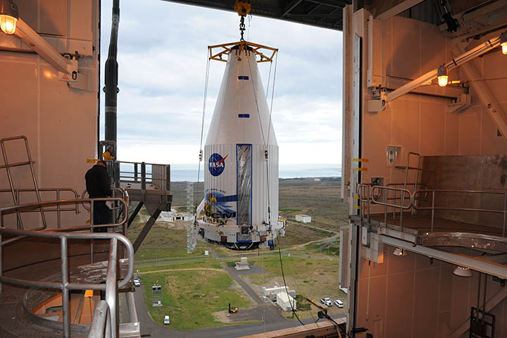
The payload fairing, with Landsat 8 inside, gets hoisted in preparation for stowing atop an Atlas 5 rocket. Photo credit: NASA/VAFB
Today is a big day. I just arrived in Los Angeles from DC this afternoon, and I’m heading to Vandenberg Air Force Base in Lompoc, California, to see an Atlas 5 rocket blast Landsat 8 into space. Officially, the satellite is called the Landsat Data Continuity Mission (LDCM) until it reaches orbit safely, but I’m going to call it Landsat 8 anyway in the spirit of keeping jargon to a minimum.
This is the second time I’ve been fortunate to have a front-row seat to the launch of one of NASA’s Earth-observing satellites. The mission that brought me to Vandenberg the first time was called Glory; it was a climate-centered mission, designed to measure aerosols and fluctuations in the amount of sunlight that reaches the top of Earth’s atmosphere.
I’m a science writer based at Goddard Space Flight Center, but I won’t sugar quote things here. That launch was a bust. When I first started at NASA about four years ago, I had been tasked with covering the Glory mission. When Glory’s launch date finally arrived on Feb. 23, 2011, I had been writing articles, websites, and fact sheets about the mission for nearly two years.
[youtube NpSUJwKBP4I]
On launch night, everything felt surreal. A weekend of press conferences, meetings, and celebrations had left me exhausted, and the launch was scheduled for 2:09 a.m. I remember standing in a parking lot with a dozen or so other reporters and colleagues waiting for the final countdown, anticipating the moment I would finally see a streak of flame arcing across the sky like I’d seen in pictures and videos of other launches.
Didn’t happen. Within 15 minutes of liftoff, mission managers put a hold on Glory. An unexpected reading from mobile launch support van had spooked the engineers. It wasn’t until March 4, 2011, that they would be ready to try again. For me, that meant no launch. I had already booked a flight home, and it would have been too expensive to change it.
When March 4 arrived, I was home in DC, following the launch online. That time, the pre-launch engineering checks went smoothly. At 2:06 a.m., from the comfort of my bed, I watched Glory roar into the morning blackness on a low-res, grainy web feed.

I arrived in California for the Landsat 8 launch on February 8, 2013. While New England was getting hammered by a blizzard, the skies over LA were calm. Photo credit: NASA/Voiland.
Even so, it was thrilling. I had been writing about the climate data Glory was poised to collect for years, but it was always as a hypothetical. When I finally saw Glory in the air, I knew I’d have *real* data to write about soon. That may not sound like much, but for me that was a huge deal. I was sick of writing about what might be.
The euphoria didn’t last long. The engineering chatter on the web stream suddenly became grave about two minutes into the launch. Something was wrong. Seriously wrong. The protective shell—or fairing—atop the rocket hadn’t separated from the rest of the rocket properly. That meant it was too heavy to escape Earth’s gravity. Minutes later, the mission was over. The rocket crashed into the Pacific Ocean with Glory still on it. (See this article I wrote for Earth magazine for more about what the loss meant for climate science).
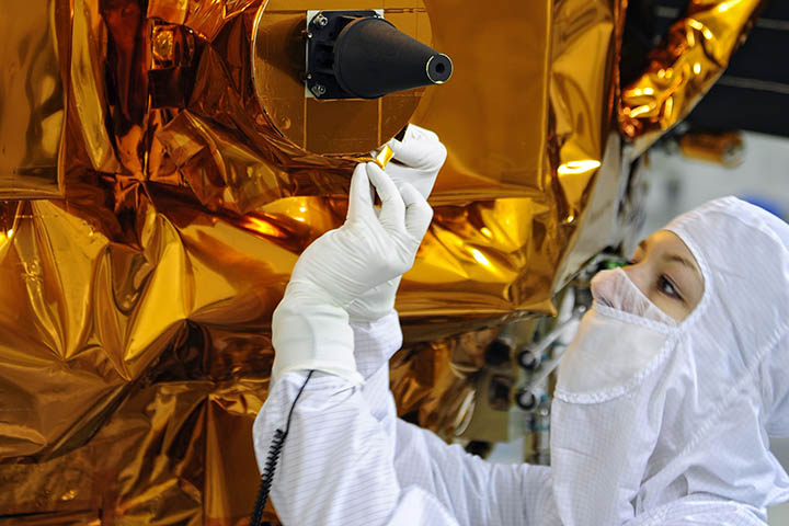
A technician works on the close-out inspection for Landsat 8 at Vandenberg Air Force Base. Credit: NASA
I’m quite confident that the Landsat 8 launch is going to go *much* better than Glory’s did. Glory was on a Taurus XL, a newer rocket that had some blemishes in its record going into launch. Landsat 8, in contrast, will be lofted into space by an Atlas 5, a launch vehicle with a near flawless record.
Still, I’m taking nothing for granted until Landsat 8 is safely in orbit and all of its instruments are on and collecting data. As I learned from Glory, launches are risky business.
Stay tuned to this space for updates about the upcoming launch, which is scheduled for February 11 between 10:02 a.m. and 10:50 a.m. PST. I’ll be blogging regularly over the next few days from California and also tweeting via @NASA_EO and @avoiland. Hope to hear from you in the comments, and please keep your fingers crossed for Landsat 8 over the next few days.
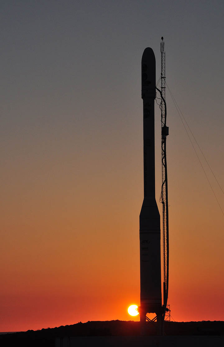
Glory on February 22, 2011, the night before its first launch attempt. Photo credit: NASA/VAFB
