
On November 23, the Royal Thai Government’s Pollution Control Department (PCD) and SERVIR-Mekong launched the Mekong Air Quality Explorer (AQE) tool at a press event in Bangkok, Thailand. Due to ongoing COVID restrictions, my colleagues from the SERVIR Science Coordination Office (SCO) and I participated in the event remotely. In working with the SERVIR-Mekong hub, I learned that poor air quality in Southeast Asia is a recurring problem that has lingered for over a decade. In contrast to smaller numbers of ground monitoring stations, Earth observations have proven essential to provide consistent and accurate air quality information. Co-developed by SERVIR-Mekong, PCD, and the Geo-Informatics and Space Technology Development Agency (GISTDA), the AQE uses Earth observation inputs in a web-based platform that forecasts and monitors air quality in the Lower Mekong region.
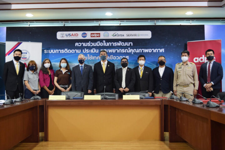
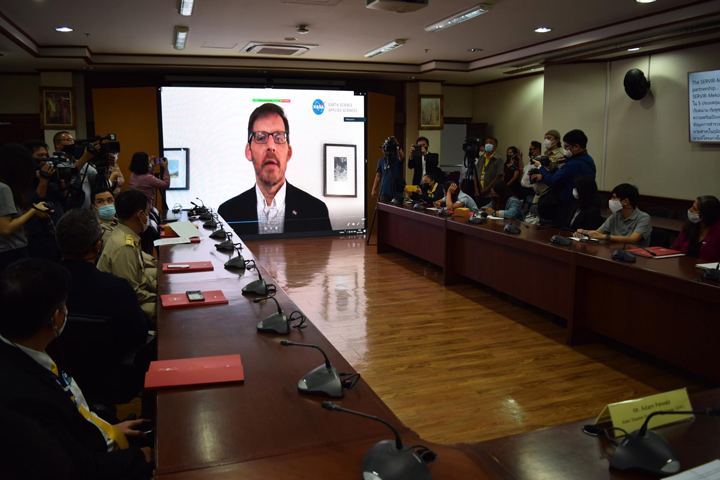
The press event took place at the Ministry of Natural Resources and Environment in Bangkok, and included remarks, a tool demo, and a Q&A session—and I got to watch it all live online. With about 40 participants, the event featured speakers such as: Mr. Athapol Charoenshunsa, PCD Director General and Chairman of the event; Dr. Steven G. Olive, Mission Director of USAID’s Regional Development Mission for Asia (RDMA); Dr. Lawrence Friedl, Director of NASA Earth Science Division’s Applied Science Program (through a pre-recorded video); and Mr. Aslam Perwaiz, Deputy Executive Director of the Asian Disaster Preparedness Center (ADPC). Additionally, GISTDA, the National Research Council of Thailand, the Prime Minister’s Delivery Unit, the Thai Health Promotion Foundation, the Department of Health, and about 20 local media channels and newspapers were at the event.
Collaboration with Local and Regional Partners
As some background, SERVIR, a joint NASA and USAID program, works with leading regional organizations to help countries worldwide use Earth observations and geospatial technologies to address environmental challenges. Led by the ADPC, SERVIR-Mekong works with organizations in countries across the Lower Mekong, including Thailand. I wasn’t working with the Mekong hub at the time, but in April of 2019, SERVIR-Mekong initiated a collaboration with local authorities to improve air quality monitoring and forecasting. The release event builds on nearly two years of research, trainings, and collaborative development in the area of air quality monitoring and forecasting. As Aekkapol Aekakkararungroj, a Remote Sensing and GIS Specialist from ADPC and my co-worker, stated: “Tackling air pollution needs to be done right now. This requires cooperation from grassroots to policy makers. Earth observation technology from space is one of the most important tools to bridge the gap—to help them better communicate, and collaboratively manage the situation on the ground.”
Research and Development for Air Quality Monitoring and Forecasting
I learned a lot about Air Quality monitoring from Dr. Gupta, the lead scientist of the AQE. He told me that in the past two decades, satellite observations of atmospheric aerosols and trace gases have been used to address surface air pollution issues. NASA has invested significant resources in researching and developing data products ready to be used in applications. The products used for the AQE are created through a research and analysis (R&A) project of NASA’s Science of Terra, Aqua and Suomi-NPP program (PI – Dr. Pawan Gupta). The R&A project focuses on air quality research and data product development for the Indian-Subcontinent, which has been expanded to include Thailand in collaboration with SERVIR. “AQE is an excellent example where NASA’s R&A program collaborated with NASA’s Applied Science program to use science for real-life application,” said Dr. Gupta.
The AQE uses aerosol and meteorological forecasts from NASA’s existing advanced climate model called the Goddard Earth Observing System (GEOS). GEOS assimilates millions of daily Earth observations and provides global forecasts up to 10 days in advance under its forward processing (FP) stream. Forecasts using the GEOS system are experimental and are produced for research purposes only. Therefore, the AQE uses NASA’s global aerosol forecasts informed by satellite observations, real-time ground monitoring data from the PCD, and an advanced machine learning algorithm to provide three hourly air quality forecasts for the next three days. The machine learning algorithm helps calibrate global forecasts with local conditions and provide better accuracy. This all sounds super cool, right?
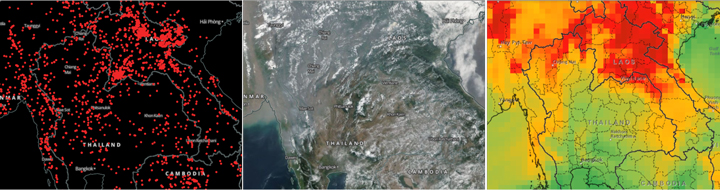
In addition, AQE has real-time satellite imagery, fire detection, and aerosol retrievals from NASA’s MODIS and VIIRS sensors. These near real-time products can help human forecasters evaluate model forecasted fields for improved decision making on final forecast outputs. AQE also has gridded historical (past two decades) data on aerosols and fires developed under the R&A project (Gupta et al., 2020). The historical datasets can evaluate change over time and help understand the impact of any significant policy changes on emissions in the region.
Capacity Building Through Training at Partner Institutions
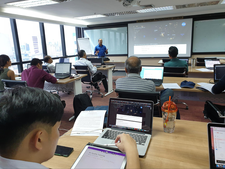
In addition to app development, the SERVIR-Mekong team has supported training and youth outreach efforts. Dr. Gupta conducted two training sessions on the Remote Sensing of Air Quality: the first for the ADPC in July 2019, and the second in August 2020 for the PCD and GISTDA, in which I had the chance to participate. The latter was supported by NASA Applied Remote Sensing Training and the Committee of Earth Observation Satellites. These trainings built technical capabilities within Thai institutions on satellite remote sensing basics, the use of satellite data for air quality applications, and advantages and limitations of satellite datasets. These trainings were also used to introduce and get feedback on AQE while still under development.
To increase youth engagement in the work, in February of 2020, SERVIR-Mekong, PCD, USAID, and the Department of State’s Young Southeast Asian Leaders Initiative hosted Smogathon Thailand 2020. The event brought together young professionals, students, and technical experts to tackle air pollution using satellite data.
Development of an Online Visualization System – An Air Quality Explorer
The AQE started as a simple visualization tool for historical aerosols and fire data to support a R&A project. Around the same time, SERVIR-Mekong showed an interest in air quality applications in the Lower Mekong region, which motivated the SERVIR team to further develop this visualization tool and include other data sets. The collaboration with PCD allowed us to use their ground monitoring data, which then combined with GEOS reanalysis (MERRA2) to develop machine learning (ML) models. These ML models were evaluated against independent datasets using a 10-fold validation strategy. Finally, an ensemble model is used to calculate surface PM2.5 for the entire region. These ML models were implemented in automatic data processing, which generate three hourly air quality index maps for the next three days following Thai air quality standards. In addition to historical data and forecasting, near real-time satellite data layers from NASA’s Land, Atmosphere Near real-time Capabilities for EO (LANCE) were incorporated in the tool. The AQE had been through testing and improvement for almost a year with all the partners, including PCD, GISTDA, and SERVIR-Mekong, before it was adopted by PCD and became part of the Thai air quality management system.

Future Work
The adoption of AQE by the PCD is an excellent example of how NASA’s science, research, and data are being applied around the world to address real-life problems. The AQE is also a first step by PCD in adopting Earth observations to complement and fill gaps in ground-based air quality monitoring systems. The AQE also addresses air quality forecasting, a gap in their air quality management program.
Since the adoption and release, PCD has already made several improvement requests for the AQE tool to serve their air quality needs. This includes improved spatial resolution, expanding the regional coverage to include neighboring countries to understand transboundary pollution, and including data on more air pollutants such as ozone, SO2, and NO2. There is also an opportunity to explore air quality observations by geostationary satellites by JAXA (i.e., Himawari-8/9) and KARI (i.e., GEMS) for the region. SERVIR-Mekong and SCO will continue to work on these aspects in close collaboration with PCD and GISTDA. I’m really excited to contribute to this effort and see the direction the AQE will take in the future!