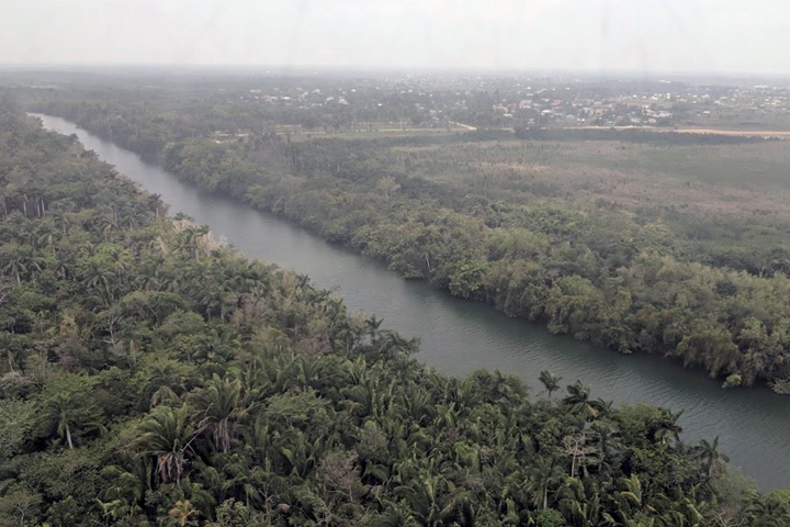
Belize is a small Central American country whose people pride themselves on trying to maintain a balance between development and conservation. I grew up in Belize City, near where the Belize River empties into the Caribbean Sea. The country’s landscape—covered by tropical forests and a network of rivers extending into the ocean—is fascinating, especially when viewed from the vantage point of space. I was able to return to Belize to join scientists from four organizations (Wildlife Conservation Society, the University of Alabama in Huntsville, the University of Georgia and NASA’s Jet Propulsion Laboratory) to kickoff research the likes of which Belize has never seen before. Our NASA-supported project, “Climate-influenced Nutrient Flows and Threats to the Biodiversity of the Belize Barrier Reef Reserve System,” (BZ-SDG for short), examines how satellite data can help with the Sustainable Development Goals (SDGs), a set of 17 goals agreed to at the United Nations’ General Assembly in 2015. BZ-SDG looks at how NASA Earth observation data can help with monitoring progress on two goals (SDGs 14 and 15), “life below water” and “life on land.” While BZ-SDG is the first NASA project focused specifically on Belize, it builds on NASA’s earlier work in Central America under the SERVIR program, implemented by USAID and NASA. The project is also a demonstration for the Earth Observations for the Sustainable Development Goals (EO4SDG) initiative.
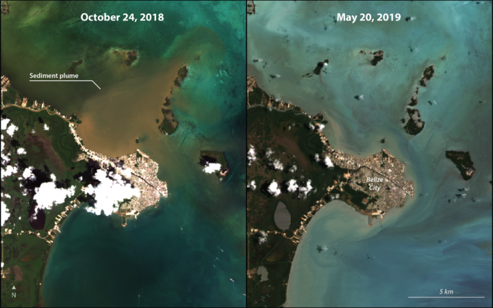
There is increased interest in using satellite imagery for monitoring coastal areas in Belize, following on a coastal zone management program that began in the early 1990s. The Belize Barrier Reef is the second longest coral reef system in the world, and local scientists want to know what impact activities on land are having on these reef ecosystems. Coral reefs are like forests of the sea, and are important for maintaining fisheries. A 2008 study found that coral reefs, in association with mangroves, contribute to between 12% and 15% of Belize’s tourism earnings. Sometimes plumes of sediments wash down the country’s river systems and can be seen by satellite images extending all the way out to the coral reefs. Activities inland were also suspected of contributing to a large bloom of green algae off Belize’s coast in 2011.
As “eyes in the sky,” satellites can survey vast extents of land, as well as the seas (i.e. the ‘seascape’), showing us information about water quality using different parts of the spectrum of light. In addition to specific satellites that focus on color of river water and sea water, there are also ways to use satellite imagery to track changes within that water, like sediments flushed into the rivers by erosion occurring further inland, or chlorophyll caused by photosynthesizing organisms.
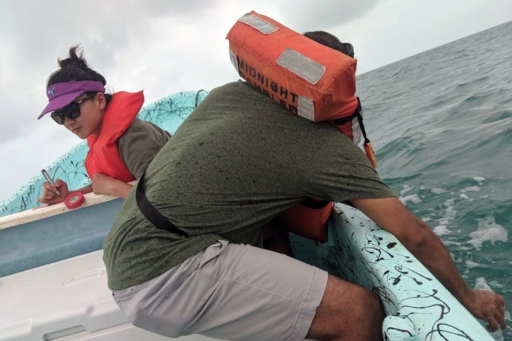
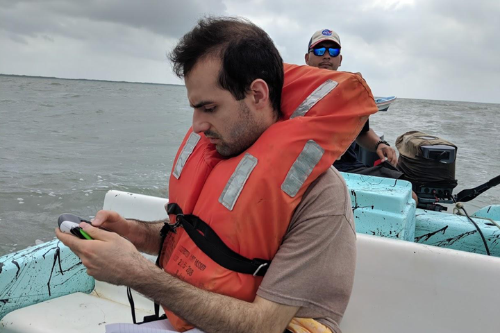
Upon arrival to Belize, we were joined by Sol Kim and Rafael Grillo, two Ph.D. students from the University of California, Berkeley, to carry out these on-site validation measurements. Over a period of two days, our team collected water quality samples on a path extending from just off the coast of Belize City all the way out to barrier reef—a distance of 15km (approximately 9 miles) out to sea. By comparing what the satellites “see” with what is measured in the field, researchers can help improve how the satellites estimate water quality in Belize’s coastal waters.
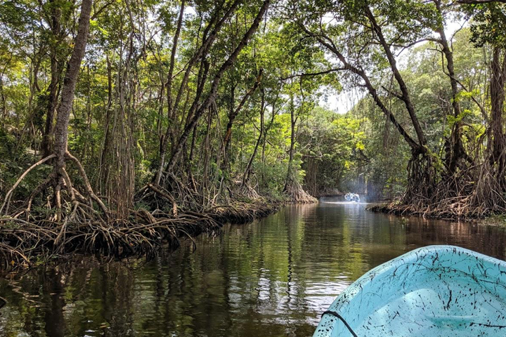
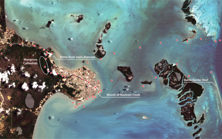
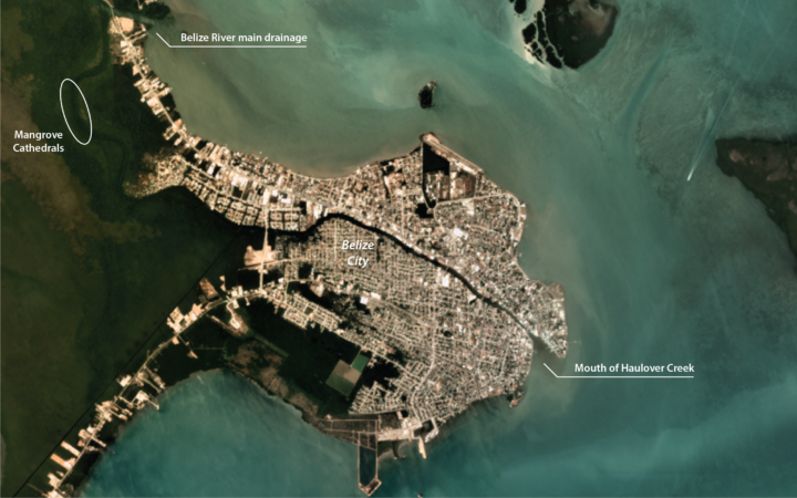
We also traveled a few kilometers up two sections of the Belize River: first, up the main channel (for a distance of 8 kilometers or 5 miles), and 10 kilometers (approximately 6 miles) up Haulover Creek, which divides Belize City north-south and is the final section of the river. Aside from the water samples collected, the Belize River “mangrove cathedrals”—stands of red mangrove (Rhizophora mangle) rising to about 20 meters (approx. 65 feet) in height—were also seen on the journey through Haulover Creek.
In total, 50 water quality samples were taken in the river and in the sea to determine sediment concentrations at each site. Additionally, using a hand-held sensor and a simple instrument called a Secchi disk, parameters like water depth, salinity, dissolved oxygen, pH, and temperature, were also measured. Locations of the 50 sample sites were geolocated using a handheld GPS receiver.
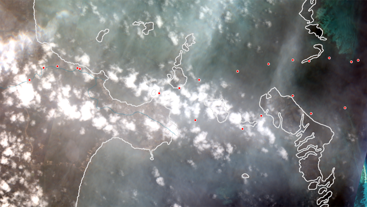
On May 15, measurements were even taken at the same time as the Sentinel-2A satellite (from Europe’s Copernicus system) passed overhead! Unfortunately, the conditions were cloudy, so it wasn’t possible to estimate sediment concentrations from that imagery.
Another fascinating part of the monitoring process is sampling in visibly tannin-rich river water near the mangrove cathedrals. Water could not be seen in different types of satellite images reviewed, including 30m Landsat imagery (NASA / USGS), 10m Sentinel-2 imagery (European Space Agency / Copernicus) or 3m Planet Labs Planetscope imagery. This is partly due to how narrow the river is, and mangrove trees overhanging the river, but it also means that it isn’t possible to use those types of images to examine water quality in portions of the Haulover Creek.
Calibrating the satellite-based estimates of water quality (from Landsat and Sentinel-2) will rely on measurements from the water quality samples collected. Since seasonal influences affect water quality, this year’s sampling was timed to coincide with the end of the dry season. Additional water quality samples are planned to be collected during the wet season later this year, as well as next year’s dry season. Using this data, our team expects to work with local partner organizations like Belize’s Coastal Zone Management Authority & Institute to provide an interactive virtual dashboard that shows how water quality is changing across the coast over time. The country will be able to quickly detect when water quality events affecting Belize’s coral reefs occur with the dashboard.
This research is supported by NASA under cooperative agreement number #80NSSC19K0200. The project team includes Nicole Auil-Gomez, project co-Investigator Dr. Alex Tewfik, Myles Phillips, Victor Alamina, Ralna Lewis, and Deseree Arzu of the WCS, project Principal Investigator Dr. Robert Griffin and co-Investigator Dr. Emil Cherrington of UAH, project co-Investigator Dr. Deepak Mishra of UGA, project co-Investigator Dr. Christine Lee of NASA JPL, and Ph.D. students Sol Kim, Xiaowei Wang, and Rafael Grillo Avila of UC-Berkeley. Dr. Cindy Schmidt, Associate Program Manager for the Ecological Forecasting program of the NASA Applied Science Program, also participated in the field visits.
