
It doesn’t take a lot of technology to see that the ocean is blue. And when it comes to the blueness of the ocean, it doesn’t get much more blue than where I am. I’m sitting on the research vessel Nathaniel B. Palmer—the largest icebreaker that supports the United States Antarctic Program—on an oceanographic expedition across the South Pacific Ocean, my current home, office, and laboratory. On this voyage, however, the Palmer has broken no ice.
Our Global Ocean Ship-based Hydrographic Investigations Program (GO-SHIP) P06 campaign departed Sydney, Australia, on July 3, successfully ending the first leg of this journey on August 16 in Papeete, French Polynesia (Tahiti). This is where our team from NASA Goddard Space Flight Center (Scott Freeman, Michael Novak, and I) joined dozens of other scientists, graduate students, marine technicians, officers and crew members, for the second and final leg that will end in the port of Valparaiso, Chile, on September 30. The GO-SHIP program is part of the long history of international programs that have criss-crossed the major ocean basins, gathering fundamental hydrographic data that support our ever-growing understanding of the global ocean and its role in regulating the Earth’s climate, and of the physical and chemical processes that determine the distribution and abundance of marine life. This latter topic regarding the ecology of the ocean is what brings our Goddard team along for the ride.
The P06 ship track, for the most part, follows along 32.5° of latitude south. That route places our course just south of the center of the South Pacific Gyre—the largest of the five major oceanic gyres, which form part the global system of ocean circulation. The Gyre—on average—holds the clearest, bluest ocean waters of any other ocean basin. This blueness is the macroscopic expression of its dearth of ocean life. We have seen nary a fish nor other ships since we departed Tahiti—this is not a major shipping route. Oceanic gyres are often called the deserts of the sea. On land, desert landscapes are limited in their capacity to support life by the availability of water. Here, lack of water is not the issue. Water, however, is at least the co-conspirator in keeping life from flourishing. Physics, as it turns out, is what holds the key to this barren waterscape.
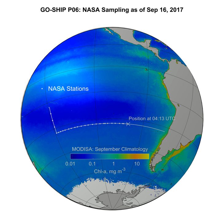
This map (above) shows the MODIS chlorophyll climatology with the ship track superimposed.
Due to the physics of fluids on a rotating sphere, such as our planet, the upper ocean currents slowly rotate counterclockwise around the edges of the center of the Gyre–as a proper Southern Hemisphere gyre should—and a fraction of that flow is deflected inward, towards its center. With water flowing towards the center from all directions, literally piling up and bulging the surface of the ocean–albeit, by just a few centimeters across thousands of miles–gravity pushes down on this pile of water. This relentless downward push puts a lock on life. The pioneers of life in the ocean, the tiny microscopic plants, known as phytoplankton, which drift in the currents, and grow on a steady mineral diet of carbon dioxide, nitrogen and phosphorus, and a dash of iron—and expel oxygen gas as a by-product, to the great benefit of life on Earth—must obtain most of their material sustenance from the ocean below. Layers of denser water trap the nitrogen and phosphorus-rich water at depth, keeping it too far down, where not enough light can reach it to spark the engine of photosynthesis that allows plants to grow.
Why are we here and where does NASA come into this story? Since the late 1970s, NASA has pursued—experimentally at first, and now as a sustained program—measuring the color of the oceans from Earth-orbiting satellites as a means to quantify the abundance of microscopic plant life. Microbiology from space, in a way. Formally, though, we call it “ocean color remote sensing.” Whizzing by at altitudes of several hundred miles, atop of the atmosphere, bound to polar orbits that allow satellites to scan the entire surface of the globe every couple of days, carrying instrument payloads of meticulously engineered spectro-radiometers—cameras capable of measuring the quantity and quality, or color, of the light that reaches its sensors. This is where our work aboard the R/V Palmer comes into the story. The data the satellites beam down from orbit do not directly measure how much plant life there is in the ocean. Satellite instruments give us digital signals that relate to the amount of light that reached their sensors. It is up to us to translate—to calibrate—those signals into meaningful, and accurate, measurements of plant life—or temperature, salinity, sediment load, sea level height, wind and sea surface roughness, or any other of the many environmental or geophysical variables satellite sensors can help us detect at the surface of the ocean. To properly calibrate a satellite sensor and validate its data products, we must obtain field measurements of the highest possible quality. That is what our team from NASA Goddard is here to do.
Around midday, typically the time of the ocean color satellite flying over our location, we perform our measurements and collect samples. We measure the optical properties of the water with our instruments to compare what we see from the R/V Palmer to what the satellites measure from their orbit above Earth’s atmosphere. At the same time that we perform our battery of optical measurements, we also collect phytoplankton samples to estimate their abundance, species composition as well as the concentration of chlorophyll-a, the green pigment common to most photosynthesizing organisms like plants, including phytoplankton. By collecting these two types of measurements at once, light and microscopic plant abundance, we are able to build the mathematical relationships that make the validation of the satellite data products possible.
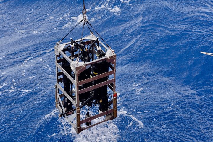
The optical instrument being lowered into the South Pacific Ocean. Credit: Lena Schulze/FSU
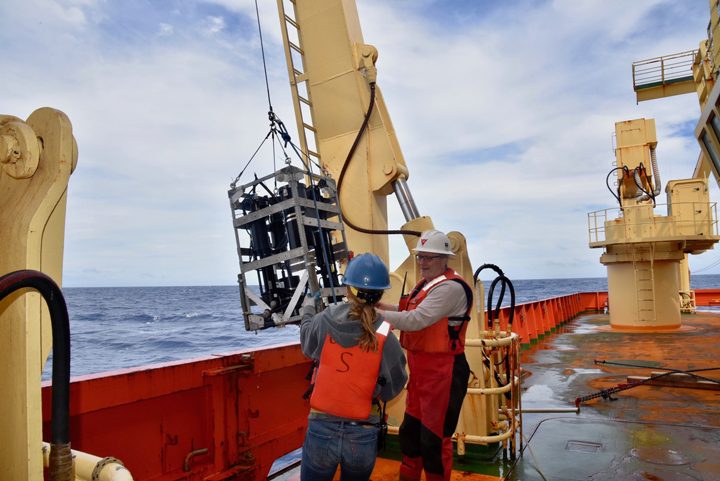
Scott Freeman of NASA works with a R/V Nathaniel Palmer crew member to prepare an instrument for deployment over the side of the ship to collect opHcal measurements. Credit: Lena Schulze/FSU
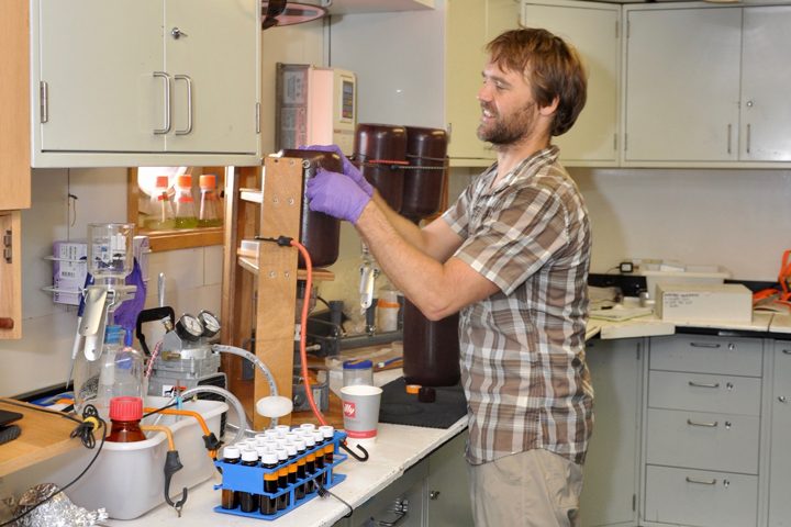
Mike Novack of NASA studies the optical and biological characteristics of seawater samples in the ship’s laboratory. Credit: Joaquin Chavez/NASA
The waters of the South Pacific Gyre are an ideal location for gathering validation quality data, perhaps one the most desirable to do so, because there are few complicating factors and sources of uncertainty that blur the connection we want to establish between the color of the water and phytoplankton life abundance. Our measurements will extend NASA’s ocean chlorophyll-a dataset to some of the lowest values on Earth. The water here is blue; in fact, it’s the bluest ocean water on Earth.
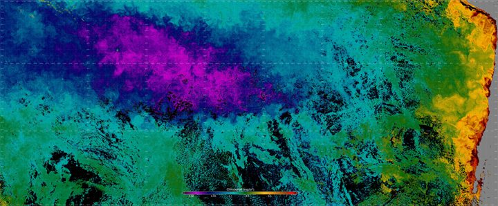
This false-color image is a composite, assembled from data acquired by the the Visible Infrared Imaging Radiometer Suite (VIIRS) on the Suomi NPP satellite between September 10-17, 2017. Yellow represents areas with the highest chlorophyll concentrations and purples are the lowest. Credit: Norman Kuring/NASA
Tags: Go-SHIP, ocean, ocean color, oceanography, phytoplankton
Thank you for such an informative and interesting article. Once your calibrations are done, what are they used to answer. Do you try to estimate the amount of Oxygen the oceans produce or what other factors.