After a lengthy waiting period, we have successfully deployed our instrumentation to make aerosol measurements inside a tropical storm/hurricane.
As of our last post, instrumentation was mounted aboard the NOAA hurricane hunter aircraft but we were awaiting installation of an inlet. This is not a trivial task, as any structure mounted to the exterior of an airplane requires a fair amount of hardware fabrication and engineering review in order to ensure flight safety. After a doubler plate was manufactured (at the interface between the aircraft and the inlet), we were cleared to make measurements. Below is a picture of our inlet on the plane (directly forward of the american flag).

NOAA WP-3D Kermit, with aerosol inlet
With the inlet installed, we were able to fly a brief test-flight near Tampa, FL, and three flights into CRISTOBAL last week. These flights were back-to-back-to-back (1 every 24-hours) with 2am takeoffs, sampling the storm at 3km altitude during its transition from depression to tropical storm (8/24), as a tropical storm (8/25), and as a weak category-1 hurricane (8/26). GOES-IR images below show the storm’s minimal organization as it slowly moved North from Hispaniola.
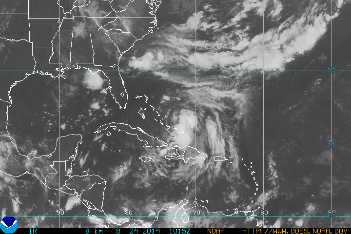
Tropical-Depression (3) – 8/24
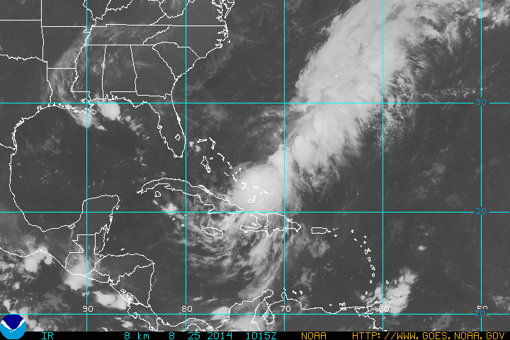
Tropical Storm Cristobal – 8/25
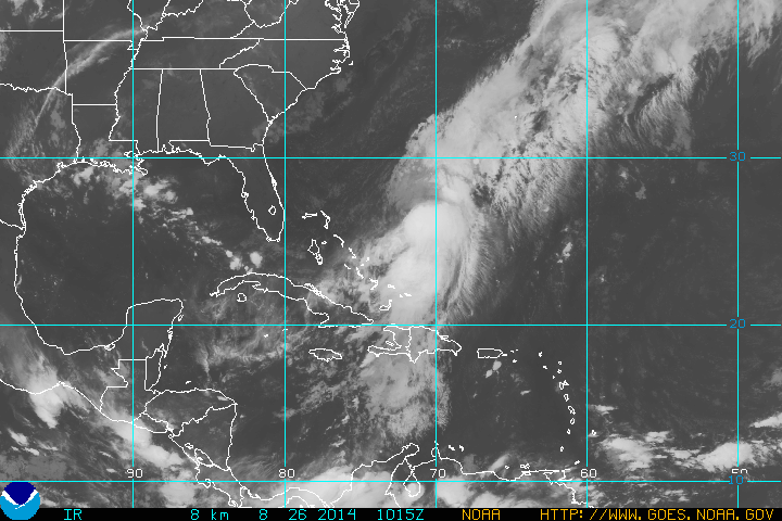
Hurricane Cristobal – 8/26
Below are a few pictures from the flights. Since there was only moderate convection, turbulence on the aircraft generally wasn’t too uncomfortable. Our 2-am take-off time allowed a very pleasant sunrise about halfway through each flight. We could even see a rainbow in the storm vicinity, an unexpected sight while inside a hurricane!

In the NE quadrant of Hurricane Cristobal. Low level clouds with lots of cirrus outflow

Rainbow during Hurricane Cristobal Flight

Typical view from the Hurricane Hunter aircraft, rain.

Sunrise flying into Tropical Storm Cristobal
If able to sample more organized storms, we hope to observe new particle formation inside the hurricane eye, a potential mechanism for intensifying the storm. Additionally, we aim to assess how hurricanes can redistribute biological particles that could act as efficient seeds for ice clouds at higher altitudes.
No storms are on the immediate horizon, but it is looking like a deployment to St. Croix is going to happen in the last half of September.
Thanks for reading. Luke
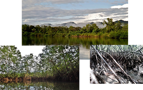
Flying over the Colombian Andes from Medellin to Nuqui in a small, 20 passenger propeller plane, five scientists peer out the window to look at the bosque (Spanish word for forest) covering the mountains below for as far as they could see. I was one of those scientists. Dotted throughout the forest, I can see indigenous communities thriving in small clearings with smoke billowing from small fire pits. Then, out of nowhere, the mountains drop off, the Pacific Ocean appears, and the plane banks hard to starboard. Finally! My first glimpse and the reason why I was making a trip out to Pacific coast of Colombia: mangroves.
My first trip to Colombia and I get to see some of the most pristine mangroves in the world. Why am I so excited about mangroves? There is something about the smell of the swamp, the harsh conditions, the incredible resilience of the trees, and the complex hydrology that draws me in. Mangrove is the general term used for a group of salt-tolerant tropical hardwood trees. Large communities of mangroves form unique forested ecosystems unlike any other forest found in tropical, temperate, and boreal climates. Though they only cover 0.1% of the earth’s surface, mangrove forests remove more carbon per unit area than any other terrestrial forest, which in turn, may be extremely important with respect to climate change and increasing CO2 concentrations. Most of that carbon from mangroves is sequestered by the thick layers of organic-rich soil that have been deposited and, most importantly, remains in these environments. Mangroves also provide a number of ecosystems services that can add up to billions of dollars in economic value per year. Some services are obvious like fishing, shrimping, timber and other raw resources. Other services are much harder to value but are still extremely important such as coastal protection, cultivating biodiversity, and cultural services. Despite their economic value or maybe because of it, mangrove forests are disappearing faster than any other tropical environment, including terrestrial forest and coral reef ecosystems, because of deforestation, coastal development and other human manipulations.
My trip was part of Vulnerability Assessment of Mangrove Forests in the Americas, a project funded by NASA’s Land Cover and Land Use Change Program and led by Dr. Marc Simard from NASA Jet Propulsion Laboratory (JPL). The project was designed to identify changes to mangrove forest ecosystems through time and space, and to understand how human activities coupled with land use/ land cover (LU/LC) change have altered mangrove environments. Researchers from NASA JPL, NASA Goddard Space Flight Center, Louisiana State University (LSU), and Indiana University (IU) have visited six sites over the course of the three year study to collect detailed mangrove and socio-economic data. This data is instrumental for developing regional models that can be adapted for diverse communities to assess mangrove vulnerability to human and climate drivers.
Our trip to Nuqui, Colombia was an effort to collect field data in pristine mangrove forests along the Pacific coast of the Americas, a location in which scientists know very little about the extent, height, and condition of the mangroves. The field data, which included tree height and tree thickness, will be used to help calibrate and validate or, in other words, make adjustments to and verify our mangrove structure and biomass models developed using a combination of remote sensing techniques. These remote sensing models use a series of mathematical relationships to estimate such things as tree height, biomass productivity, and carbon sequestration. The other collaborators on the project from LSU collected soil cores while IU initiated a locally-lead program to conduct socio-economic surveys. Fifty centimeter soil cores were collected at each of the sites to determine the amount of carbon found in the ground, which is the largest reservoir for carbon in these ecosystems. Socio-economic activity and demographic information collected from detailed surveys will help us to understand the relationship between the human environment and the changes to the mangrove forests.
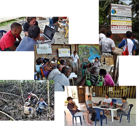
(Top left) Skype meeting between NASA JPL interns and researchers from MarViva about remote sensing of mangroves. (Top right) Team America reading about the “Plan de Manejo Manglar.” (Center) Mangrove presentation to the community leaders of Nuqui. (Bottom left) “Mangrove 101” with Edward Castañeda, from LSU. (Bottom right) Team America preparing for meeting with community leaders.
Before any scientific trip to another country, there is a ton of planning and connecting with local agencies to help ensure that you don’t run into any complications. Shortly after our arrival in Nuqui, Colombia, we checked into our hotel and began working on a presentation to show to the local leaders from several small pueblos that comprise the coastal region of the municipality of Nuqui. The presentation was to let the communities know; 1) why we were there, 2) why we are interested in mangroves, and 3) how our research will help the local communities.
The first two points were fairly straightforward. We had preliminary maps from the area which showed us that some very tall, 20-30 meter mangroves were growing in the region. We were there to “groundtruth,” or check out how accurate our modeled tree height estimates were and collect new data to develop better models. Very few studies have investigated mangroves along the Pacific coast and Nuqui was the perfect location to find intact forest ecosystems. Moreover, the coastal communities of Nuqui are dependent on many of the ecosystem services provided by the mangrove forests which include timber/ raw materials, fisheries, coastal protection, and water purification. We tend to forget that we are also part of the ecosystem, and that our actions will have a direct impact on changing the landscape. Nuqui has realized this and has carried out a “Plan de Manejo de Manglar (Mangrove Management Plan)” in the area of Tribugá. The plan includes three “zonas”: de uso sostenible (sustainable use), recuperación (restoration), and preservación (preservation). Mangroves are a necessary part of the coastal Colombian life and rooted deeply into their culture, so much that even the Vice-President of Nuqui, Enrique Murillo-Palacios, was moved to sing about his appreciation for those beloved trees during a dinner we had been invited to.
[youtube ozl3hV-CuUU]
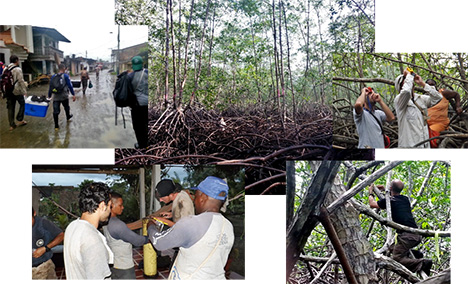
(Top left) Walking home after a long field day in the rain. (Center) Marc Simard, from NASA JPL, measuring tree height. (Top right) Marc Simard showing Hector, from MarViva, how to use the inclinometer. (Bottom left) Cutting soil cores with MarViva and the Vice-President of Nuqui, Enrique. (Bottom right) David Lagomasino, from NASA GSFC, measuring tree diameter above the mangrove prop roots.
We addressed the third objective of our meeting, to show how our research will help the local communities, by working with local community members and local Nonprofits in the field. In addition, we also shared data between groups; some data we collected and other data that MarViva had been previously collecting. Over the course of the field campaign, a handful of local community members and two researchers from MarViva came with us out in the field to collect data. All the groups had their own area of expertise. The locals knew the layout of the land; where the shoals were along the river, where the tallest mangroves were, and a detailed background of the area. MarViva had permanent plots set up at various mangrove sites in the area of Tribugá. And Team America (inside joke: name for the US collaborators of the project) had the expertise in remote sensing, spatial statistics, and mangrove physiology.
While we were out in the field, we showed the locals how to measure tree height using inclinometers, measure tree thickness using diameter tape, and how to collect soil cores. Simple geometry has been integrated into the inclinometer and diameter tape. The inclinometer can estimate tree height by measuring the angles to the base and top of the tree from a set distance from the tree. Two triangles can then be drawn from these measurements using geometric techniques and, voila!: tree height. Old-school surveyors did this all by hand, but nowadays there are fancy inclinometers that integrate all the measurements in a single device with one output… tree height. The diameter tape also integrates geometry by using the relationship between the circumference and diameter of a circle. Collecting soil core tends to be a little more rudimentary, but one must consider a few technical issues first, such as soil compaction and suction, before just hammering a PVC pipe into the ground. From the soil cores we can obtain information about the rate of deposition, the amount of biomass, and the concentration of carbon in the ground. Getting muddy from field work can be one of the best parts of a project. Plus it’s always fun to parkour across a jungle-gym of mangrove prop roots.
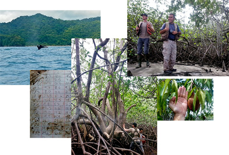
(Top left) Run-in with a pod of Humpback Whales during our initial site visit. (Top right) Asher Williams and Edward Castañeda, from LSU, learning about a new species of mangroves we had never seen before. (Bottom left) Always, always take a picture of your field book. (Center) Asher admiring one of the only black mangroves (Aviecennia germinans) we came across at our field sites. (Bottom right) Fruit from a mangrove tree.
Edward Castañeda, from LSU, gave an impromptu “Mangrove 101” course to local volunteers while we were taking a break in the field. Professor Castañeda discussed the various physical adaptations that mangroves have developed to cope with the harsh saline environments and remove the high concentrations of salts in the water. Some mangroves can thrive in water with salinities above 90 parts per thousand. That’s almost three times the salt concentrations found in the oceans! There are three main mechanisms that mangroves have developed to allow them to live in salt water: salt exclusion, salt excretion, and shedding. Salt exclusion occurs at the roots where thin membranes prevent salt from entering into the xylem. The excretion technique removes excess salts using glands found in the leaf. You can actually taste and see the salt on the undersides of some leaves. Lastly, some mangrove species can store excess salts in glands from “sacrificial leaves” that fall to the ground, removing the accumulated salts from their system.
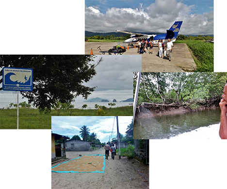
(Left) Always know where your lines of egress are. (Top) Transportation out of Nuqui. (Right) Marc Simard, from JPL, admiring the mangroves while on a boat ride to our next site. (Bottom) Almost lunch time in town of Tribugá.
After a week of working with the local communities and long days of fieldwork, there were mixed feelings about leaving. Sure, we wanted to get back to hot showers and air conditioning, but being able to see the sites, that we primarily research remotely, we began to formulate more and more questions. What makes the mangroves so big? How does the hydrology influence mangrove communities and tree growth? How deep are the mangrove soils? How far inland to the mangroves extend? Though we may not have an answer for these questions now, it is through collaborations with local agencies and educating local communities that can help us to eventually address research gaps. Town members from Nuqui learned about mangroves and their importance to carbon cycling and MarViva learned about new techniques to survey their field sites. Team America learned much more than we bargained for. Not only did we collect lots of field data for our remote sensing biomass and socio-economic models, but we learned a lot about the culture of Nuqui and how truly important mangroves are in their/our lives.
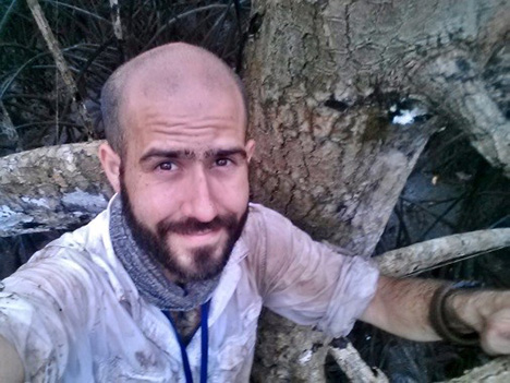
I stare out into the forest from my perch atop a mangrove prop root, surveying the near-impenetrable entanglement of the forests’ footing. In the distance, calls of “Árbol H6, DAB 4.5, Altura 12 metros” are muffled by the rain. Then I remember that I climbed up here to measure the thickness of the tree… but first, let me take a #selfie.
“If there are no mangrove forests, then the sea will have no meaning. It is like having a tree with no roots, for the mangroves are the roots of the sea.”
-Thai Fisherman (Trang Province)
A new NASA airborne campaign known as ARISE, or the Arctic Radiation – IceBridge Sea and Ice Experiment, will take measurements intended to help researchers better understand the role that clouds play in Arctic warming as sea ice conditions change. From Sep. 3 to Oct. 3, researchers flying aboard NASA’s C-130 research aircraft will measure incoming and reflected sunlight, thermal infrared radiation, ice surface elevation and various cloud properties to gain a better understanding of changes to the Arctic climate.

NASA’s C-130 research aircraft sitting in the hangar at Wallops Flight Facility as it is being prepared for the ARISE field campaign. Credit: NASA / Christy Hansen
For the past few weeks, aircraft technicians and instrument experts have been preparing the C-130 for its upcoming trip to the Arctic. A large part of this process was installing and testing the scientific gear that the ARISE team will use to collect data on clouds and ice.

Land, Vegetation and Ice Sensor (LVIS) instrument and control racks aboard the NASA C-130 research aircraft seen during instrument integration at Wallops Flight Facility in Virginia. LVIS is a laser altimeter that will be used to measure land and sea ice elevation during NASA’s ARISE campaign.
Credit: NASA / David Rabine
Once the instruments are installed and tested on the ground, the ARISE team carried out a pair of check flights – one to make sure the C-130 is flying in peak condition and one to verify that the mission’s various instruments are working properly.

A view of NASA’s C-130 research aircraft seen from the T-34 chase plane during the ARISE engineering check flight on August 24, 2014.
Credit: NASA / Dennis Rieke and Mark Russell
For the next few weeks, the ARISE team will fly out of Eielson Air Force Base, Alaska, to collect data on Arctic ice and clouds.
