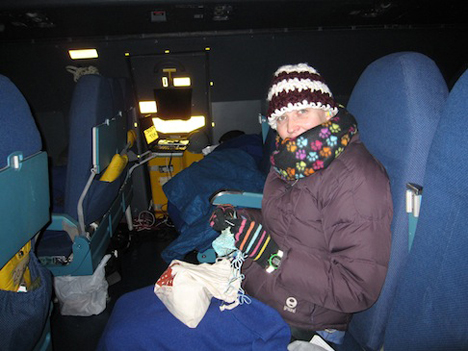
Science writer Ellen Gray bundled up on the C-5. Credit: NASA / Michael Starobin
Thursday, November 21
When they told us to dress in layers for the flight, they weren’t kidding. At altitude, the C-5 transporting the Global Precipitation Measurement satellite is cold. After waking up from my exhausted sleep that passed the first five hours, my feet were blocks of ice from the draft along the floor. I was wearing three shirts and a sweater under my jacket, long underwear and pants, and winter hat, gloves and scarf.
Others were starting to get up and move around. The project brought all our own food for the trip, and the passenger area had a small galley with small ovens to heat it up. Tin foil dishes of crab cakes, chicken wings, roast beef and vegetables; sandwiches and chips; and pancakes and eggs for breakfast.

Flying Air Force is Bring Your Own Food. Credit: NASA / Michael Starobin
After eating, I moved to the back of the passenger section where there was a free double seat, so Michael Starobin, the video producer joining me documenting the trip, could stretch out on the row we shared. The best thing about the back rows? They’re warmer than up front.
Cozy with my two blankets, I was almost asleep again when project manager Art Azarbarzin came by. “Did you hear?” he asked loudly over the engine noise and the ear plugs. I shook my head. “We’re going to have to land. The headwinds are eating up too much fuel.”
The C5 was originally supposed to be refueled in the air, en route, making the flight about 15 hours long from Andrews on the U.S. East Coast to Kitakyushu, Japan. Fighting upstream, as it were, against the headwinds meant the calculations for our expected fuel usage, even with the in-air refuel, wouldn’t be enough to get us all the way to Japan.
“We’re landing in Alaska,” Dani Alvardo told me after we got more information from the Air Force crew. Specifically, we were landing at Elmendorf Air Force Base near Anchorage. “The refuel should take two to three hours. Hopefully. More than that and it might be one or two days before we get to Kitakyushu,” he said.
Two hours or two days? It all depended on staying inside the time waiver granted to the C5 flight crew to fly for an extended period of time before they had to go on mandatory rest, and whether or not the tiny Kitakyushu Airport would let us land on Saturday, the same day they had a 747 flying in. Everyone was crossing their fingers that we could get down, get fueled, and get gone before the clock ran out.
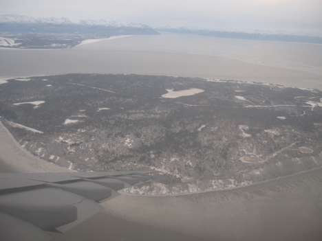
Descending toward Elmendorf Air Force Base, near Anchorage, Alaska. Credit: NASA / Michael Starobin
I’d never been to Alaska before and my first view of it was actually a picture Michael Starobin took out the emergency exit window. Anchorage is on the water, and bare trees and snow already covered the landscape. When we deplaned, we were hit with bitingly cold air. I thought Maryland was cold at 37 degrees F when we were standing outside at Andrews. At Elmendorf it was 7 degrees F. Was I ever glad that dressing for the C-5 meant breaking out the winter gear.
Fortunately the Air Force loaded us onto a heated bus where we waited next to the plane. I listened in as project manager Art Azarbarzin checked in with Mike Miller who was monitoring the g-forces inside the container as we landed. One g is the force of gravity that holds us to Earth’s surface. GPM felt less than one g from the deceleration of the plane, which is very good for the spacecraft — it didn’t jostle around. The temperature inside the container held steady in the high 60s F with the help of the heater on the Environmental Control Unit, and the dry Alaska air helped the unit with keeping the relative humidity below 60 percent. The satellite was in good shape.
While we waited, breathing diesel fumes and watching F22s take off, the joke went around that we should have taken the Hawaii route (short answer, flying over Hawaii is a longer route to Japan). But after about two hours we were boarding the C-5 again, and forty minutes later, we were taxiing down the runaway. We sat and waited again for our turn to take off.
Then we got the announcement. We were grounded. The crew was on 17 hours of mandatory rest. They were two minutes over their waiver deadline.
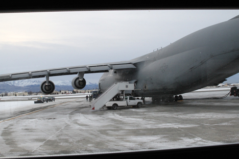
The C-5 on the ground at Elmendorf Air Force Base near Anchorage, Alaska. Credit: NASA / Michael Starobin
Friday, November 22
Nine a.m. in Alaska at this time of year is still full dark. But out we went to the bus that shuttled us from the Air Force Inns to the air field. It was raining. Worse, it was 25 degrees F outside so it was freezing rain.
Jean Manall, the logistic coordinator for GPM’s shipment, said as we walked out the door, “We’ve got to be optimistic.” But optimism won’t beat bad weather. We waited by the airfield for an hour before getting back on the bus to the Air Force Inns. The base had closed the airfield.
Our new departure time was Saturday morning, for a Sunday arrival in Kitakyushu, Japan. The good news was, we don’t have a time limit at Kitakyushu Airport like we did for Saturday because of the 747. The bad news was, we couldn’t take any more delays. While we were waiting to check back into our rooms, Jean came up to Art and told him our permits to close the road and drive the spacecraft from the airport to the boat for the next leg of its journey expired on Sunday.
Art laughed, resigned, as he pulled out his phone to call JAXA to update them on the schedule and warn them we might need an extension if the weather didn’t let up. “It’s more complex getting to the launch site than building the satellite,” he joked.
At 4:30 a.m., Nov. 21, a knock came at the door of the Goddard bus from one of our Air Force escorts at Andrews Air Force Base, outside of Washington, D.C. It was time to board the Super Galaxy C5 cargo plane. The NASA team of 24 slowly woke up from the naps most of us were taking while we waited in the warmth of the bus. We arrived at Andrews at midnight for a 2:00 a.m departure that was pushed to 3:30 a.m. then 4:30 a.m. while the C5 crew finished loading and securing the cargo.
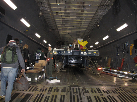
The GPM team boards the C5. Yes, that’s a truck. Credit: NASA / Ellen Gray
A few people grabbed bags that they hadn’t taken up to the passenger section when we first arrived, and we file up the ramp into the belly of the massive C5. It’s a little bit like I imagine being swallowed by a whale might feel.
When the Global Precipitation Measurement mission’s project manager Art Azarbarzin first told me that in addition to the GPM satellite’s shipping container, we were taking along the roller bed truck, minus the engine, I didn’t know how to picture it in my head. I’d seen the shipping container. I knew it was big, and I couldn’t conceptualize how it and a truck would all fit onto a single aircraft. But the C5 is truly huge, and there the truck was, chained to the deck.
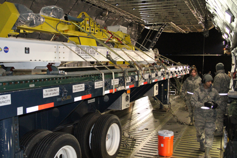
The roller bed truck loaded on the plane. Secured on top are the FlipRight (yellow) for manipulating the spacecraft once it’s in the cleanroom in Japan and the I-beam sling (white) that facilitates the heavy lifting of the container. Credit: NASA / Michael Starobin
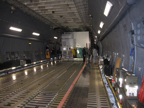
Immediately behind the truck at the center of the plane is the GPM shipping container, its top clearing the ceiling by an inch and its width taking up all but two narrow aisles to either side. On each side, sixteen thick chains strapped the shipping container to the deck. They angled up in the walkway, making for a nice tripping hazard to pick our way through.

The crew securing the GPM shipping container to the deck. Credit: NASA / Michael Starobin
Behind the shipping container is more cargo space where six loaded pallets were strapped down: our vacuum-wrapped luggage, the secondary environmental control unit and generator for the shipping container, the flight and spare batteries for the spacecraft, and boxes of tools and equipment for moving and handling the shipping container. From the ceiling, attic stairs descend, narrow and steep, up to the passenger section of the plane above.
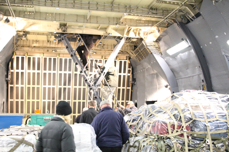
Heading up to the passenger section. Credit: NASA / Michael Starobin
Gripping the railing with two hands, we file up. My first impression was that it is very blue — blue seats, blue floor, blue ceiling and walls. The rows only stretch back about half the length of the plane, three seats to a side. With only 24 of us, those who are working the unloading get first pick of a full row to themselves.
Once everyone gets situated, we get the same FAA safety briefing, you’d get on a commercial flight: Put you seat backs and tray tables in their upright and locked positions. Ours however was read from a manual by a young airman, getting through the words as quickly as possible. When it was time for the demonstrations, we skipped the seatbelt buckle and got a lesson on how to put on what is essentially a bubble over your head that will keep out smoke and provide oxygen in case of a fire.
As the rest of us shut off our electronics, Mike Miller and Neil Patel in the seats across the aisle fired up their laptops. They’re two of the team that monitors the spacecraft inside the shipping container 24/7. An ethernet cable from the sensors in the container stream a constant feed of what’s happening in there — temperature, humidity and vibration — so they can make sure everything is where it should be. They’ll be on for the whole flight.
While we waited for take-off, most of the team sacked out under the blue wool blankets distributed with the noise of the engine muffled by ear plugs. It was cold up there. The only windows are over the four emergency exits so the only way to tell we were moving was the vibrations through the floor and change in pitch from the engines. But it wasn’t long before they roared to life and we were in the air and on our way.
One of the keys to IceBridge’s success is effective communication between every member of the team. But keeping in touch in the remote locales IceBridge operates from can sometimes be tricky. On plane there’s the intercom system routing through headsets and the radios and Iridium satellite communication devices aboard the P-3 allow the plane to communicate with someone on the ground virtually anywhere in the world.

NASA P-3 aircraft technician Kevin Moore assisting IceBridge project manager Christy Hansen with the onboard Iridium satellite communications system during an IceBridge survey flight on Nov. 19, 2013. Credit: NASA / George Hale
But what about when the team is on the ground? When everyone is in the office or their rooms then email works. When away from the office, however, things get more complicated. Some areas have mobile phone coverage and it’s easy to take such a thing for granted these days. But in Antarctica, a locale where keeping in touch can literally be a matter of life or death, cell phone service is nonexistent. Even in a developed station like McMurdo the smartest of phones becomes nothing more than a pocket-sized music player, camera and entertainment device.
To meet the communications needs of people living and working in this often harsh environment, three tools some people might consider virtually obsolete: the landline telephone, the two-way radio and the pager.
Phoning It In
In the U.S., many homes are ditching their landlines. But in Antarctica they’ve never gone out of style. The backbone of the system is different, as calls are routed through the internet through the U.S. Antarctic Program’s office in Denver, but from the user’s perspective things are just as they were years ago.
Dorm rooms, offices and common areas all have telephones that can be used to call others on the station. IceBridge’s two main work areas, McMurdo’s Crary Lab and the team’s tents at the sea ice airfield, have telephones set up, allowing team members in these two locations to stay in touch.

One of the IceBridge team tents at McMurdo’s sea ice airfield. Inside the tent is a telephone, which team members can use to keep in touch with everyone back in McMurdo town. Credit: NASA / Jefferson Beck
Turn the Page
If you know someone is in their room or at the office, calling them on a landline phone is by far the quickest and most reliable way to contact them. However, it isn’t uncommon for team members to be out tending to instrument ground stations, unloading cargo or visiting the weather office for the latest forecast. In these cases, team members rely on a seemingly obsolete technology, the pager.
Before the widespread adoption of cell phones, personal pagers were fairly common. You’d call someone’s pager and enter your phone number and their device would beep, showing that you wanted to talk to someone. That person would then need to find a phone and give you a call. As inconvenient as this sounds the infrastructure for a paging system is more robust and less complicated than that needed for cell service.
IceBridge project manager Christy Hansen and project scientist Michael Studinger turn off their pagers before taking off on the Nov. 19, 2013, IceBridge survey flight. Credit: NASA / George Hale
The pagers at McMurdo Station are a little more advanced though, allowing for text pages and updates. By sending an email to a special address you can send a short message to someone’s pager and station management use the pager network to send out updates on weather conditions, something of vital importance in an environment like Antarctica.
On the Radio
Pagers and telephones work out great in town or between town and the airfield because nobody is terribly far from a phone at any time. But for people working outside of town, such as the people setting up instrument ground stations or the team who did the GPS survey of Black Island more than 20 miles away, an extra step is called for. This is where the two-way radio comes into play.
Members of the Airborne Topographic Mapper team return from an attempt at a ground survey mission conducted on nearby Black Island. Credit: NASA / Jefferson Beck
The VHF two-way radios used at McMurdo are a great way for widespread teams to keep in touch. Each radio can tune into one of a handful of channels dedicated for different purposes. IceBridge personnel communicate on the science channel, while shuttle drivers and airfield personnel would use different channels.
Putting It All Together
Although not as convenient as the average smart phone, the combination of land line telephones, pagers and two-way radios provides a way for people living and working in Antarctica to stay in touch with one another.
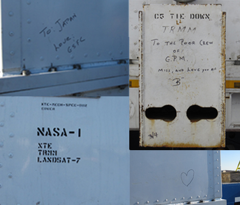
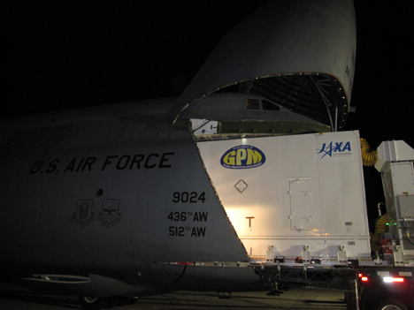
“To: Japan, Love: GSFC.” So says a note, written in black marker on the outside of the Global Precipitation Measurement (GPM) shipping container. This is at least the fourth satellite that has been transported in this particular container. Stenciled officially on another corner are XTE, TRMM, and Landsat-7. Someone on a previous transport team left a note on an external box used to secure the container to the C5 that reads: “To The Poor Crew of GPM. Miss, and Love you All, ‘B’.” On the fourth corner is a small heart.
The day the GPM team loaded this well-loved container and its cargo onto the C5 cargo plane was a long day. It began at Goddard Space Flight Center in Greenbelt, Md. at noon on Nov. 19, beautiful and blustery, and ended at around 2:25 in the morning, dark and bone-chillingly cold at Andrews Air Force Base. Everything moved slowly: the drive from Goddard, the transfer of the shipping container from one truck to another, the loading of the plane.
“Be extremely cautious, take your time,” said mechanical team member Dani Alvarado as he briefed everyone before they got started. “This is the real deal.”
Here are the highlights.
12:00 p.m.
The first leg of GPM’s journey was by truck to Andrews Air Force Base, escorted by a van and a pickup advertising the oversize load. Behind, followed a caravan that included those of us accompanying the satellite. The center section of the truck-trailer carrying the container is only about a foot or so off the ground, so the top of the container was low enough to clear the two underpasses on its route. At first, everyone in the bus trailing behind ducked their head into the aisle to make sure it made it under. It did, just barely.
~4:00 p.m.
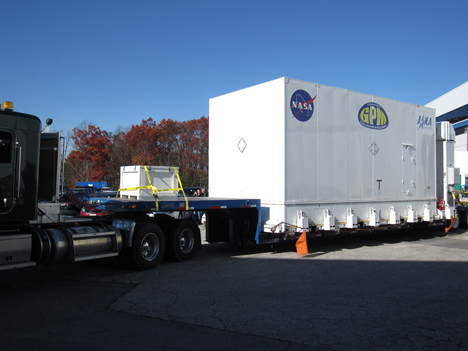
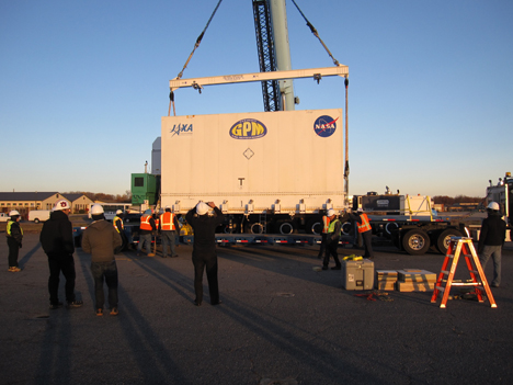
Once we arrived at Andrews Air Force Base the first task was to transfer the shipping container from the truck it rode in on to a truck bed covered in rollers. The roller bed, specially designed for NASA satellite transportation, allows the container to move smoothly from the truck to the plane. The roller bed truck followed in the caravan from Goddard, bringing with it two pieces of equipment: a FlipRight machine for moving the satellite around once it arrives in the clean room in Japan and the I-beam sling shown above that attaches to the crane to lift the container. Altogether, the satellite, container, and sling weigh about 62,000 pounds. Up the container went, the first truck drove out from under it, and the roller bed truck backed up under the container in its place.
8:00 p.m.
Originally the C5 was supposed to arrive at 4:30 p.m., but birds on the runway in Dover where it was coming from caused a delay. Since they’re close to a refuge, the Dover base keeps “bird hours,” and can’t take off until they fly away to roost. So the GPM team took a dinner break. The C5 arrived after dark at 6:45 p.m. as three lights on the horizon. It took another hour for the crew to taxi and get the plane ready with its nose in the air, looking like a shark with its jaws open.
~8:30 p.m.
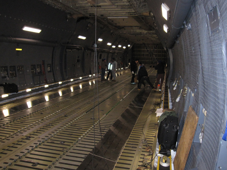
As soon as they could, the GPM team got started prepping the plane for the container. The floor of the C5 has rows upon rows of small rollers down the center, but since the container is wide, the GPM team laid down metal covered wood tracks. Next they attached mounts to the outside of the shipping container that would hold roller skates that they put into place as the Air Force crew pulled the container onto the plane with a chain in short bursts.

~10:30
The shipping container is about an inch shorter than the distance from floor to ceiling of the cargo area on the C5. Wiggle room was practically non-existent. The roller truck had to back up, pull out, and back up again to get the container perfectly aligned. The Air Force crew had to adjust the height of the docking platform so the weight of the container shifted directly onto the plane and the container remained level. There were a few false starts, but the container made it on board in the end, looking like it was being swallowed whole.
1:10 a.m
Darkness made it hard to fully appreciate the size of the C5, but taking a look inside and seeing the shipping container look small really brought it into perspective.
Before the first survey flight of an IceBridge field campaign can get under way a lot of things have to happen. Instruments have to be installed on the plane, researchers need to get into the field and ground stations need to be set up.
IceBridge’s McMurdo-based Antarctic campaign is the result of a year and a half of planning and preparation, all of which came together during a highly choreographed logistical dance that spanned more than a week and half of the globe.

NASA IceBridge team member Theresa Stumpf, right, and other passengers deplane upon arrival at McMurdo’s sea ice runway. Credit: NASA / Jefferson Beck
After a nearly four-week-long delay of a few weeks caused by the U.S. government shutdown, IceBridge went into high gear to finish up preparations for a shortened campaign. Before anybody could start on their way to Antarctica the mission’s scientific instruments needed to be installed on the P-3. Over a period of about two weeks, aircraft technicians and instrument team members at NASA’s Wallops Flight Facility in Virginia installed IceBridge’s scientific gear.
While this part of the team was finishing up their work at Wallops, a different group started their journey to the ice, flying to Christchurch, New Zealand, to receive their cold weather gear. While the rest of the IceBridge team was finishing up their work on the P-3 and traveling to the ice, this small group was busy laying the groundwork for the campaign by unpacking shipments, setting up GPS ground stations and preparing for a GPS ground survey of a nearby island.

Members of the Airborne Topographic Mapper team, Kyle Krabill, Robbie Russell, and John Sonntag, set up a ground station to help calibrate their GPS systems, a critical step to getting accurate data in the field. Credit: NASA/Jefferson Beck
With instruments installed and ground tests complete, most of the rest of the team packed up for the long flight south. Remaining behind were a handful of instrument specialists and pilots and crew for the P-3. Scientists and instrument operators would travel to Antarctica while the P-3 and its onboard instruments underwent a series of check flights.
With these final checks of the aircraft and instruments complete, the remaining few instrument specialists who remained behind followed the first and second waves of IceBridge personnel on commercial flights to New Zealand. This differs from the mission’s previous campaigns because normally scientists and instrument operators fly on the NASA research aircraft to the field location.

Operation IceBridge team members celebrate as the NASA P-3 aircraft taxis in from its first landing at McMurdo Station’s sea ice runway on Nov. 16th, 2013, Operation IceBridge pilots brought the aircraft over to its parking spot where it will rest between missions to survey Antarctic ice over the next few weeks. Credit: NASA/Jefferson Beck
The reason for the difference this time is that the transit from NASA Wallops to McMurdo Station in Antarctica would take several days. Going to Thule, Greenland, on the P-3 takes less than eight hours and traveling to Punta Arenas, Chile, on the DC-8 takes a 12 hour flight to Santiago followed by a shorter hop to Punta Arenas the next day. But this time, the P-3 would have to make stops in California, Hawaii and American Samoa, flying eight hours each day, before making it to the last stop before the ice in Christchurch.
The P-3’s arrival on Nov. 16 marked the completion of a long and complicated process and the beginning of a new and historic field campaign. For the first time ever a large, wheeled NASA aircraft would operate directly from Antarctica.
