
Walt Petersen is the Ground Validation Scientist for the Global Precipitation Measurement (GPM) mission, based at NASA’s Wallops Flight Facility in Virginia. He manages all of GPM’s ground validation operations, the field campaigns that ensure that satellites measure rainfall and precipitation from space accurately.
From May 1 to June 15, he is leading the Iowa Flood Studies, or IFloodS campaign in eastern Iowa. He and his team, as well as their partners at the Iowa Flood Center at the University of Iowa are measuring rainfall with ground instruments, ground radar, and satellites, and then evaluating flood forecasting models. Over the next few weeks, Walt and others on the ground will be sending us their notes from the field.
4/29/2013, NPOL Radar Site near Traer, Iowa
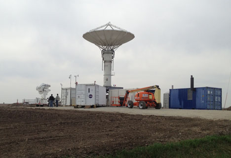
Apr 29, 2013. The NASA Polerametric (NPOL) precipitation radar (center) scans for rainfall in both the horizontal and vertical planes to measure precipitation throughout the whole volume of the air column. The smaller D3R radar is to the far left. Credit NASA
This morning, my first full day around the area of Waterloo, Iowa. Quite appropriately, we were greeted by severe thunderstorms with some ping pong ball-sized hail in the area. Luckily for my rental car, and even more luckily for the NPOL and D3R antennas, that hail stayed north of the radar site (large hail, rental cars, and/or radar antennas not being the best mix). I thought it an appropriate welcoming to the experiment. I drove out to the radar for the first time this morning in my little Nissan rental car. I’ll be curious to see how it does on the gravel/dirt road after it rains a few inches.

Apr. 25, 2013. A team of NASA staff and Iowa Flood Center and University of Iowa students assist with the NPOL setup in eastern Iowa. Credit: Aneta Goska, Iowa Flood Center.
Things are impressive out here. The NPOL and D3R guys did a very nice job of getting the NPOL and D3R set up. We are still in the midst of tweaking small things prior to getting down to serious data collection. For example, we need to make certain that the NPOL is well-calibrated (doing that now), and then we need to test the timing of our scan sequences to make sure we are making the requirement that we sample the rain field in a 360 degree circle once every 3 minutes or less. The objective is to make rapid maps of rainfall (out to a range of say, 150 km, from the NPOL) at high time and space resolution, and then in between making those rain maps, do coordinated scanning of the precipitation in the vertical plane with the D3R radar or over other river basins of interest. The rapidly collected rain maps serve as a reference for doing our comparisons to satellite products and to test products for hydrologic modeling of runoff (e.g., flood forecasting).
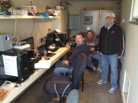
Apr. 29, 2013. The science trailer where data from the radars is collected. From left to right, Walt Petersen, Dave Wolff, and Delbert Willie. Credit: NASA
The coordinated scanning with the D3R is done for a slightly different reason. These scans are collected along a line that has many raingauges and disdrometers located at different points so that we can connect the dots between the rainfall we are measuring near the ground (for example, rainfall rates and raindrop sizes, numbers and shapes) to the physics happening in the column of the atmosphere above those points (e.g., how the rain is made). We care about this from the perspective of testing algorithms designed to retrieve precipitation estimates from space using the GPM DPR radar (which has similar frequencies to the D3R) which will fly on the GPM Core satellite.