
Daily Report from Dr. Jon Ranson
Embenchime River 66 N 97 E
9:00 a.m. local, 9:00 p.m. EDT
65°F high 52°F low Sunny
It is a beautiful day on the Embenchime! The sun is shining, the skies are clear with just a few clouds scattered in the sky. We’re 282 miles in a straight line north of Tura. The river isn’t straight, however, so it’s more like 480 miles by boat. Earlier a brisk breeze blew the mosquitoes away, but not so much now. We pitched our tents on a dry, rocky bar along the river, and the local horde has come to greet us. Now I finally feel like I’m on an expedition!
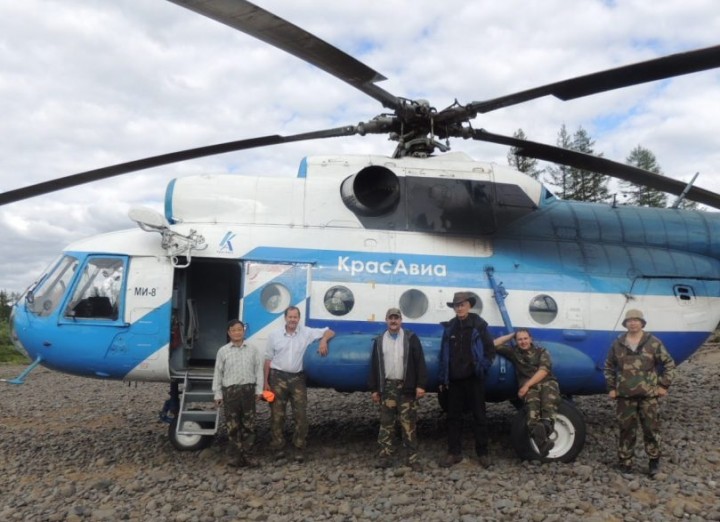
The scientific team at Tura airport, ready to head to the Embenchime. From left to right: Guoqing Sun, Ross Nelson, Jon Ranson, Slava Kharuk, Sergei Im and Pasha Oskorbin.
Guess what we had for our inaugural camp meal? Fish soup! For those of you who have followed our blogs since 2007, you know that fish is a staple meal. But it’s nothing like the chowder many Americans are familiar with. Our Russian colleagues prepare the soup by cleaning freshly caught fish, then chopping them up, head and all, and dropping them in a pot of water, along with some spices. It’s pretty tasty, and nutritious, as long as one doesn’t east the sharp bones. But even a good thing can go too far – in 2007, we ate so much of it that some of us were having serious fantasies about other food – like French fires and pizza. Tonight, it tasted very good.
This morning we packed up and drove to the airport. We arrived early to talk to the company that rents helicopters. It turns out that they also have a big bi-plane available for rent. They use it for remote area deliveries for people and supplies, and for reconnaissance. It’s not at all like the little crop dusters one might think of when they hear bi-plane. It’s very big, and can carry a good sized load of people and gear.
It looks like we could have access to this plane next year, and it looks like it will be quite feasible to house and run the G-HLiT instrument from this plane. We’d like to find a Cessna, because that’s the plane that the instrument was designed to fly aboard. But this Anatov An-2 is a real possibility – and much better than a helicopter.
One major driver of this expedition is preparing for the flights of the G-LiHT Instrument over the next two years. G-LiHT stands for Goddard’s LiDAR, Hyperspectral, and Thermal airborne imager. It’s an instrument package that was put together by Bruce Cook at his team at NASA, and is designed to be a better tool to study forested ecosystems. It has two lidars, which are high resolution and can measure canopy crowns and gaps, and identify low growing vegetation. The hyperspectral and thermal instruments in the package can help characterize species, pick up photosynthetic pigments, and measure surface temperatures. The instrument package can even help determine environmental stressors, such as moisture content of the leaves, and help figure out whether we’re looking at a shrub or rocks – something we’re not getting from our space-based instruments. We think this is a great instrument package, and will give us really good data – but we need to locate an aircraft to fly it aboard, and we need fresh data from the field to help calibrate it in these larch forests.
The current lidar data we have available is ICESat 1 data. That stands for the Ice, Cloud, and land Elevation Satellite. The instrument on board, called GLAS (Geoscience Laser Altimeter System) was designed to measure ice, and clouds. The ICESat missions focus on ice and cloud, primarily. Vegetation can be measured, but it is a second thought for this program. ICESat 1 decommissioned from service in 2010. The replacement, ICESat 2, the next-generation satellite designed to look at ice and clouds in the polar regions, won’t be launched until 2016.
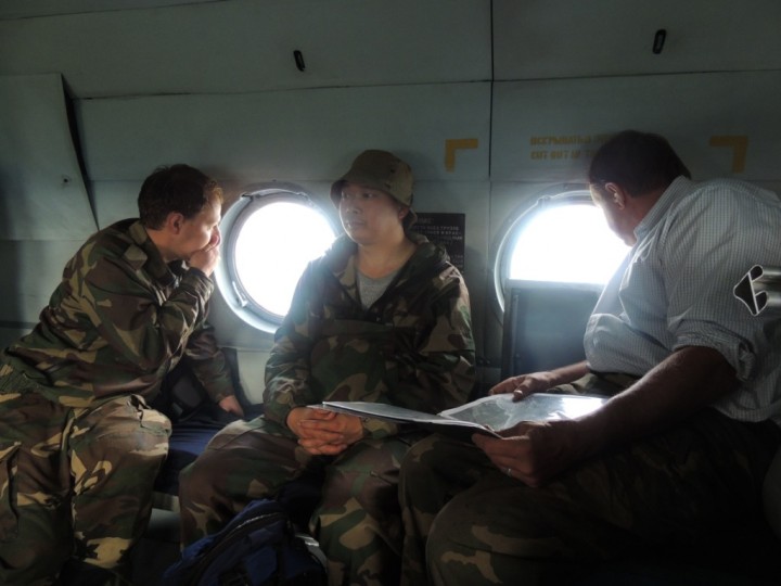
Nearing the landing site, Ross Nelson (left) and Pasha Oskorbin (right) excitedly anticipate arrival. Sergei Im (center) practices patience.
The boreal region is important, and it’s changing. In order to understand what is happing in this part of the world, we have to be able to have instruments that can measure vegetation – the above ground biomass, where a lot of carbon is stored. It’s just vital work, and it can’t wait for ICESat 2. Because the need is so immediate, we can’t create a new satellite fast enough. So Bruce and his team went to work to pull together this extremely portable, very functional instrument package. And we’re ready to get out and use it.
But first, we had to get to the river. We had a little hitch at the airport. We drove into the Tura airport through the freight gate, because it was near the helicopter. Ross, Guoquing, Slava and I were all crammed into the van, with a huge pile of gear in the back. As icing on the cake, Slava’s shotgun was perched on top of the pile. The gate was guarded by a serious looking mature lady, in an impressive uniform. She nodded and asked Slava questions in Russian. He answers, and all seems well. Then she walked around the van and looked inside. I could tell when she saw the shotgun, because her pleasant look hardened and her head began shaking vigorously and firmly. No translation was needed – in any language, she was saying “no way are you going anywhere with that gun”.
We took a little diversion to a different building, where Slava chatted with officials and finally received clearance. The shotgun received a personal escort. It was hand carried to the helicopter by an unformed official. He personally loaded the gun onto the helicopter – I believe they put it forward with the pilots, because I didn’t see it again until we arrived on the river. Carrying a gun is a big deal here – it can be done, but they do make sure there’s not a chance that anyone will discharge it near the aircraft.
We had a good flight in. It was exciting to be flying over these remote forests again. After a two hour flight northward, the pilot set down on a rocky bar – our new home. We started unloading tents, clothes and sleeping bags – it’s just a huge pile of stuff. And it’s ours to care for and carry downriver for the next two weeks.
As soon as we landed, one of the helicopter crewmen hopped off the plane running, with a fishing rod in his hand. He ran to the river, tossed in his line, and started pulling out fish. Soon another crew member was downstream, fishing. The first caught six in just a few minutes; the other caught several as well. The moment our gear was out, however, they were back in the helicopter and then, within a few minutes, we were all alone on the river. They were good sports, though – they left us three fish. Three fish is a good start, but hardly enough for dinner for six scientists. So we went fishing too. Slava caught a seven pound pike, and I caught a pretty big fish, too. Soon we had enough for fish soup.
We’re camping on a big rocky bar, with trees all around. The river is beautiful. Fishing is good, too, but that’s not why we are here – we’re here to make measurements and collect data. The closest GLAS point is about 500 meters away. Tomorrow, we’ll break into two crews, and half of us will go northeast and half of us southwest and we’ll collect the measurements we can here tomorrow. There are a lot of GLAS footprints around – that’s the instrument on ICESat which provides us with the best available data to date on forest structure. We plan to measure heavily from this spot, and then move down river. I’ll be glad to get out and get measuring.
While we were just finishing up dinner, and trying to get the sat connection going – we found a serious glitch. The data terminal is not working. We checked it out in Maryland, and it was great. We have a strong signal, and everything looks like we should be fine. But it appears we have a problem with permissions of some sort. I’ve tried to reach the 24/7 support line of our provider, but had no luck. The crew back at home – my office staff and our writer, Joanne, will work on this today, and hopefully we can bring you photos soon.
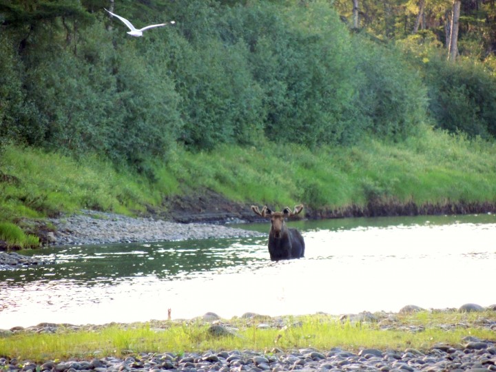
A large bull moose crossed the river twice, about 200 m upstream from the camp. He seemed to have a quietly challenging attitude, as if patrolling his territory and firmly suggesting that the scientists stay on their side of his line. The GLAS footprints lie in Papa Moose’s territory, however; tomorrow the scientists will make measurements in that forest. Hopefully the bull will be willing to share his lands.
We’re seeing a lot of wildlife this trip, so far. There were lots of birds in Tura. I’ve seen ravens, pigeons, European house sparrows, arctic terns, gulls and a whole lot of things I couldn’t identify. One of the birds in Tura was a small brown bird, with red on his tail. I asked Slava to tell me the name of the bird, and he said something in Russian – something I won’t ever remember. He said it translated to “bird who has his tail in a fire”. Russian can be a very poetic and descriptive language!
While we were in camp, a big bull moose came out of the forest about 200 yards upstream of us. We didn’t scare him at all – but he certainly took notice of us. He walked across the river very slowly, looking at us the whole time. Soon he crossed very slowly back again. He was magnificent, but he seemed to be challenging us a little. Like he was showing us the edges of his territory, and warning us to stay out of his space. If that’s the case, it’s unfortunate – because our first plots are right in that direction. In the morning, we’ll be heading straight for Papa Moose’s land.
It’s 9:20 p.m. here, and the sun is still up. I have a good 45 minutes before the sun sets behind the hill right in front of us. In Tura the sun went down at 11:30 p.m. and came up at 3:30 am, so that makes a 4 hour night. But the night is more of a dusky light, they say. Of course, I am asleep for those 4 hours, so I can’t testify personally to that.
Tonight, I can’t wait on the sun to slip below the horizon in order to go to sleep. I’ll be slipping into my sleeping back to try to get some much needed rest on the rocky ground. Tomorrow will be a long and physically strenuous day. I’m looking forward to it.
Writer’s note: After speaking with Jon, I worked with Jacob Gude, the Biospheric Lab’s secretary, and between the two of us we were able to contact the satellite phone provider. The service technician, Andy Cool, once we were able to reach him, provided prompt and diligent service. It turns out that there was a problem with permissions required by the Russian government – new requirements that had just been put into place. The company was able to solve the problem, and the data terminal now works. It is slow, and high resolution photos are too big to be sent from the field. But we do now have the ability to post photos from the field – and are quite grateful for the good stateside assistance.
To All Involved on that River trip ,,, Congradulations on a Job Well Done,,
That Took One Herculean Feat to Accomplish that ,,,
That’s Out in the ” BOON DOCKS ” for Sure ,,,
Sincerely ,, Eddie ,,
Hi Eddie! Scientists will work very hard, and travel very far, to try to find out what is true in this world. Each year hundreds of scientists undertake similar challenges – some even more dangerous and difficult that this expedition – in search of knowledge. Science is very important, and it is hard work – but it can be a great adventure, as well, sometimes! Joanne