There’re two instruments on the Beech King Air B200. One is the HSRL, which stands for High Spectral Resolution LIDAR. The latter word is an acronym born out of the marriage between RADAR and LASER. Even Radiohead use it. The one mounted on the B200 is an advanced device that my colleagues at NASA Langley have been extensively deploying. It pulses a laser beam straight downwards, and records the time it takes for light to come straight back after it bounces off particles. Based on this information, the atmosphere below the airplane is profiled and the height of aerosols layers effectively located.

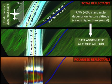
The Research Scanning Polarimeter (RSP) is somewhat weirder, as polarization is a kind of information that is greatly masked to humans’ vision capabilities. Ask bees. If you wear sunglasses though, you should know that they cut the glare because they filter out light waves oscillating in all directions other than that vibrating in a certain direction.
Light is a wave, but most instruments can only measure the amplitude (=intensity) of it. Instead, the RSP adds to it by recording at which angle the light wave vibrates. As you can expect, the change of this angle as a light wave scatters off a a particle is extremely sensitive to the size and shape of the particle.

We hope we can exploit the synergy between these two instruments to nail the vertical distribution and nature of aerosols in the atmosphere. Our studies confirm the potential of integrating the information derived by the complementary capabilities of the two instruments, sort of “Tell me where you are, and I’ll tell you who you are”.
Why do we do this? These instruments are “the little brothers” of the CALIPSO LIDAR (already in space), and the polarimeter that will be launched onboard the Glory mission at the end of this year. These satellites will fly shoulder by shoulder (just a few seconds apart!), therefore observing at any instant the same scene. You can even have your name orbiting with us!
-Matteo
Tags: CALIPSO, Glory, LIDAR, NASA B-200, RSP


