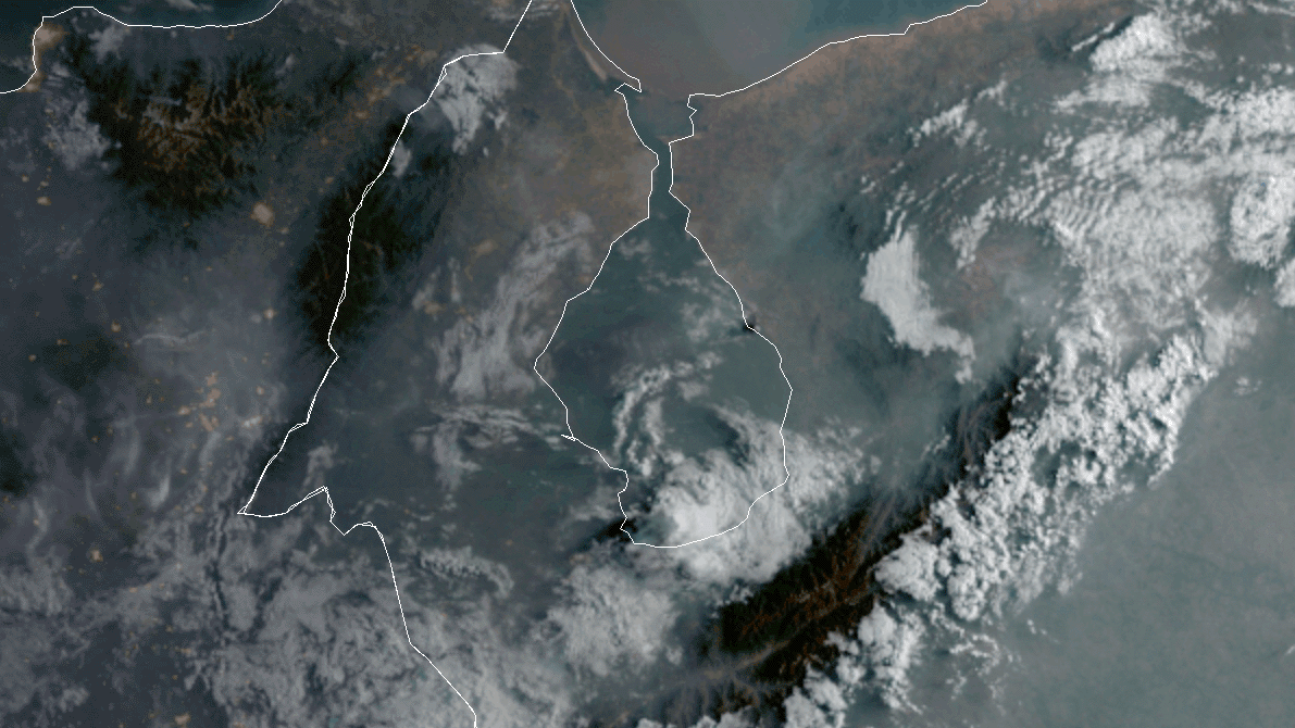
As noted in a recent Image of the Day (“A Fiery Month in Zulia”) satellites have detected lots of fire activity in western Venezuela in recent weeks. Just as we were finishing that story, a surprisingly large, dark smoke plume appeared in VIIRS and MODIS imagery. It bore little resemblance to the smaller, gray plumes that we had been watching. Forest and crops fires had caused the earlier plumes; the new black smoke was caused by a brush fire that had spread into a crude oil storage area, according to news reports.
The animation above shows the progression of the plume on the morning of April 25, 2020. The images were collected at 10 minute intervals by the Advanced Baseline Imager (ABI) on NOAA’s GOES-16 satellite. Sensors on other satellites caught glimpses of the short-lived plume as well, including the Multispectral Instrument (MSI) on the European Space Agency’s Sentinel-2 satellite and the Ozone Monitoring Instrument (OMI) on NASA’s Aura satellite.
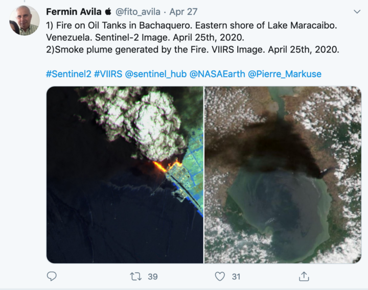
With dozens of firefighters battling the blaze, it was extinguished by the next day. On April 26, 2020, there were no signs of smoke or active fires visible in MODIS and VIIRS images of that area.
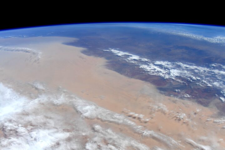
Baked by heat and drought, deluged by rain and floods, scorched by wildfire, and blanketed by dust, Australia has faced several months of extreme weather.
Some of the latest jaw-dropping images come from NASA astronaut Christina Koch. “Australia. Our hearts and thoughts are with you,” she tweeted, along with images of a massive dust storm making its way across the continent and smoke streaming from bushfires in southeastern Australia.
Meanwhile, Jean-Paul Vernier, a senior scientist at the National Institute of Aerospace at NASA Langley Research Center and the lead of a NASA disasters team responding to the fires, has been using data from the CALIPSO satellite to measure something impossible to discern from an aerial photograph, even one taken from space—the height of the smoke. As we reported earlier, the fires are so intense that they have lifted smoke all the way to the stratosphere, something wildfires do only occasionally. (Usually, volcanoes lift plumes to such heights.)
On January 6, 2020, the smoke had reached 19 kilometers (12 miles). Interestingly, it kept rising. By January 13, it was up to 21 kilometers.
“The radiative heating from the soot particles within the smoke makes wildfire plumes particularly buoyant, meaning they will reach higher altitudes in the stratosphere and stay there longer than material from a volcanic eruption that reaches the same initial altitude,” Vernier explained.
As satellites track Australian wildfire smoke from above, GLOBE Observer citizen scientists have been keeping tabs on hazy skies from the ground.
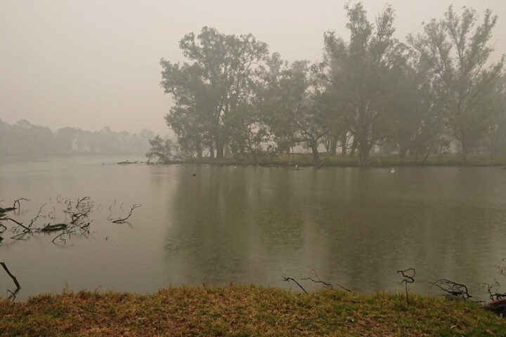
The photograph above shows smoke blanketing Horseshoe Lagoon in New South Wales on January 6, 2020, a day when clouds limited what sensors on Terra, Aqua, and Suomi NPP could observe as they passed over.
The video below, based on photographs taken by GLOBE citizen scientist Glenn Evans, juxtaposes satellite images and photographs taken of the sky at roughly the same place and time. The contrasting perspectives underscore how easy it can be to miss the forest for the trees — or, rather, the smoke plume for the clouds — if you aren’t careful. Kristen Weaver, the deputy coordinator for GLOBE Observer, compiled the photos and matched them with the corresponding MODIS satellite images.
Victoria and New South Wales are in the midst of one of the most severe fire seasons either state has seen in decades. After months of unusually hot, dry weather, hundreds of fires have charred an area larger than West Virginia, destroying thousands of homes and resulting in dozens of deaths.
GLOBE Observer is a citizen science project that is part of the Global Learning and Observations to Benefit the Environment (GLOBE) Program. Through a free app for their mobile device, anyone in participating countries can make environmental observations of clouds, trees, land cover, and mosquito habitats that complement NASA satellite observations.

NASA image courtesy Jeff Schmaltz, LANCE MODIS Rapid Response. This image was acquired on July 11, 2012, by the Aqua satellite.
One of the first things that caught my eye when I started checking for interesting satellite imagery yesterday was this: an enormous “V” of smoke draped over northern Canada, as seen by the MODIS instrument on the Aqua satellite. The plume was caused by numerous wildfires burning in the Caribou Mountains of northern Alberta.
At first glance, what looks like a decorative swash on the upper left of the V even reminded me of the look of the N we use on the Earth Observatory to indicate the orientation of an image. It made me think the two might in essence share the same typeface. In fact, the bottom point of the capital V of Adobe Jensen Pro (the typeface of our N) is much wider and curvier than the point in the smoke above. (Wired points out it also looks like the letter Z, which is true if you rotate the image clockwise a bit.)
Still, it’s a memorable image. And it made me wonder: how many other letters have satellites captured momentarily gracing Earth’s atmosphere and oceans? This is the first that I’ve noticed, but I have no doubt there are many more to find given the ceaseless mixing and swirling of clouds, smoke, dust, ice, and even phytoplankton that constantly occurs across our planet.
I think it would be fun to compile a gallery of them, so if you’ve seen a letter (or other typographical mark) in a satellite image, please let me know. Just leave a comment on the thread below. Send a link to what you’ve found, and explain what letter or other typographical mark you think you see.
If you’re feeling especially ambitious, mention what typeface it reminds you of as well. I’ll update this post as new letters come in, and perhaps we’ll eventually have the whole alphabet (plus a good collection of numbers and symbols). Sending non-English characters is ok: just note what the character is and what it’s called.
Wondering where you can look for imagery besides the EO archives? Here are a few places to try:
1) NASA Visible Earth
2) The Gateway to Astronaut Photography
3) Jet Propulsion Laboratory Photojournal
4) Scientific Visualization Studio Archives
5) MODIS Image Gallery
6) Landsat Imagery Gallery
Please note: Our gallery won’t likely include many of the high-resolution commercial satellite images that you may have seen on Google Earth because we cannot reproduce those images on our website without buying them. Besides, medium-resolution and low-resolution satellite instruments are actually better for observing large features such as clouds and smoke plumes. Here’s a list of some of the high-resolution instruments that we’ll only be using sparingly, if at all.
