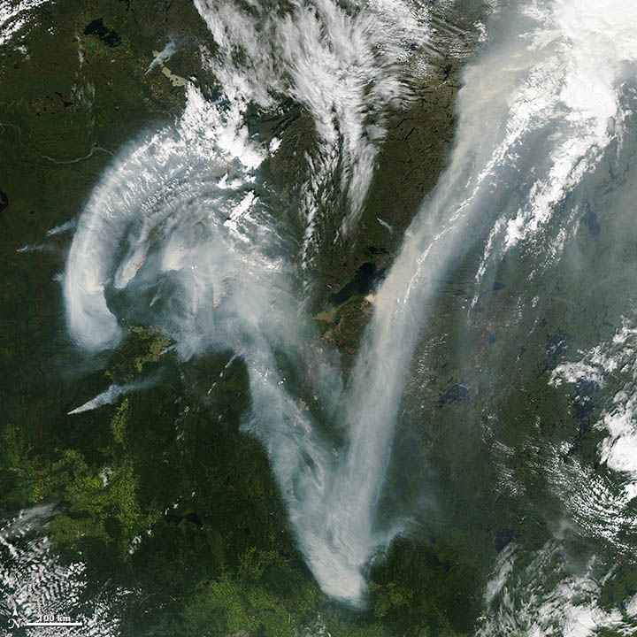


NASA image courtesy Jeff Schmaltz, LANCE MODIS Rapid Response. This image was acquired on July 11, 2012, by the Aqua satellite.
One of the first things that caught my eye when I started checking for interesting satellite imagery yesterday was this: an enormous “V” of smoke draped over northern Canada, as seen by the MODIS instrument on the Aqua satellite. The plume was caused by numerous wildfires burning in the Caribou Mountains of northern Alberta.
At first glance, what looks like a decorative swash on the upper left of the V even reminded me of the look of the N we use on the Earth Observatory to indicate the orientation of an image. It made me think the two might in essence share the same typeface. In fact, the bottom point of the capital V of Adobe Jensen Pro (the typeface of our N) is much wider and curvier than the point in the smoke above. (Wired points out it also looks like the letter Z, which is true if you rotate the image clockwise a bit.)
Still, it’s a memorable image. And it made me wonder: how many other letters have satellites captured momentarily gracing Earth’s atmosphere and oceans? This is the first that I’ve noticed, but I have no doubt there are many more to find given the ceaseless mixing and swirling of clouds, smoke, dust, ice, and even phytoplankton that constantly occurs across our planet.
I think it would be fun to compile a gallery of them, so if you’ve seen a letter (or other typographical mark) in a satellite image, please let me know. Just leave a comment on the thread below. Send a link to what you’ve found, and explain what letter or other typographical mark you think you see.
If you’re feeling especially ambitious, mention what typeface it reminds you of as well. I’ll update this post as new letters come in, and perhaps we’ll eventually have the whole alphabet (plus a good collection of numbers and symbols). Sending non-English characters is ok: just note what the character is and what it’s called.
Wondering where you can look for imagery besides the EO archives? Here are a few places to try:
1) NASA Visible Earth
2) The Gateway to Astronaut Photography
3) Jet Propulsion Laboratory Photojournal
4) Scientific Visualization Studio Archives
5) MODIS Image Gallery
6) Landsat Imagery Gallery
Please note: Our gallery won’t likely include many of the high-resolution commercial satellite images that you may have seen on Google Earth because we cannot reproduce those images on our website without buying them. Besides, medium-resolution and low-resolution satellite instruments are actually better for observing large features such as clouds and smoke plumes. Here’s a list of some of the high-resolution instruments that we’ll only be using sparingly, if at all.