
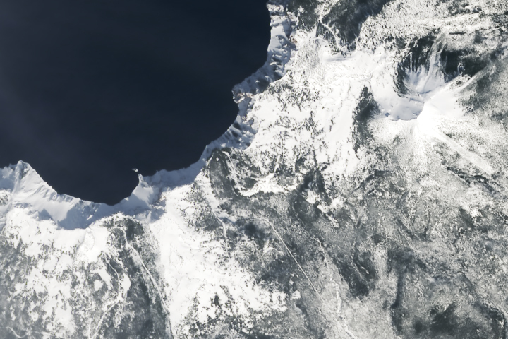
Update on April 17, 2023: This puzzler image shows Crater Lake in south-central Oregon in March 2023. The lake is especially scenic in early spring when its deep-blue waters contrast with a blanket of snow on land. Congratulations to Dan Taylor for being the first reader to correctly identify the image. Read more about the location in our Image of the Day story.
Every month on Earth Matters, we offer a puzzling satellite image. The March 2023 puzzler is shown above. Your challenge is to use the comments section to tell us where it is, what we are looking at, and why it is interesting.
How to answer. You can use a few words or several paragraphs. You might simply tell us the location, or you can dig deeper and offer details about what satellite and instrument produced the image, what spectral bands were used to create it, or what is compelling about some obscure feature. If you think something is interesting or noteworthy, tell us about it.
The prize. We cannot offer prize money or a trip on the International Space Station, but we can promise you credit and glory. Well, maybe just credit. Within a week after a puzzler image appears on this blog, we will post an annotated and captioned version as our Image of the Day. After we post the answer, we will acknowledge the first person to correctly identify the image at the bottom of this blog post. We also may recognize readers who offer the most interesting tidbits of information. Please include your preferred name or alias with your comment. If you work for or attend an institution that you would like to recognize, please mention that as well.
Recent winners. If you have won the puzzler in the past few months, or if you work in geospatial imaging, please hold your answer for at least a day to give less experienced readers a chance.
Releasing Comments. Savvy readers have solved some puzzlers after a few minutes. To give more people a chance, we may wait 24 to 48 hours before posting comments. Good luck!
Melting continental ice shelf near water?
Seems too busy to be from Antartica so…from Greenland perhaps?
It’s interesting to see the wide Albedo contrast between the white ice (high Albedo) that is melting and becomes darker until it becomes water (low Albedo).
This is a winter (or at least snow covered) image of Crater Lake’s south east shore and the Phantom Ship overlook. 42.91418714598855, -122.07135555720538
Crater Lake fills the caldera of the dormant volcano Mt. Mazama as well as being the second deepest lake in North America and one of the deepest in the world.
The volcano itself is powered by the Juan De Fuca plate sliding under the North America plate. Wizard island (not pictured here) is a cinder cone formed after the eruption that destroyed the original summit.
I am so happy …
I hope – pictured for extremly snowy peak on Crater Lake Oregon… I hope … Ivan
Crater Lake (unfair advantage for Oregon residents :-))
I work at the American Museum of Natural History and we have a small diorama depicting a view from near this spot on the SE quadrant of Crater Lake, it could be just at the western edge of this photo. I went to try to find the location of the diorama many years ago, and couldn’t quite access it because of all that white stuff. 🙂 I think it was late June when I visited. It is truly a breath taking Lake. A must see. The contrast of the white snow and the blue waters, and the whole cladera, on that sunny day was a view I will never forget.
California coast after big snow event. It looks like the snow blew west to east so only western sides of mountains are snow covered. This is unusual because California doesn’t usually get snow.
Hello NASA’S Earth Observatory
This is the southeast margin of Crater Lake in Oregon, USA. The lake now fills the caldera of Mt. Mazama, a volcano in the Cascade mountain range that formed from seafloor subduction of the Pacific plate under the North American plate. The volcano exploded 7700 years ago which emptied the magma chamber and was subsequently filled with water. The clarity of the lake water is exceptional because most of the water is snow melt or groundwater flow, which reduces turbidity. Mt. Mazama once stood more than 12,000 feet and now is North America’s deepest lake at 2000 feet deep. Measurable ash deposits from the eruption have been found as far as Nebraska.
Great winter image of the Dutton Cliffs/Phantom Ship section of ancient Mount Mazama. Reviewing my notes on their significance, Dutton and the Phantom are remnants of the oldest flows and vents.
Crater Lake, Oregon, measuring snow pack
I believe this to be the SE corner of Crater Lake OR., Mt Scott to the right, east, Garfield and Applegate lower left.
Crater Lake, National Park, Oregon. Southern shoreline of crater, overlooking Phantom Ship with Mount Scott in the east.
Not sure why interesting. Live in Melbourne. Australia
Lake Como
It’s Crater Lake of Crater Lake National Park in Oregon. It’s famed for it’s depth, but what’s especially interesting about this photo is how it shows the unfrozen surface of the lake during what I presume is winter. The lake’s depth and volume relative to it’s small surface area means (similar to Lake Tahoe) an exceptionally cold and prolonged winter is required to freeze the surface of the lake. Wicked cool.
Crater Lake, Oregon. Mt Scott is on the right side of the image, and the tiny island known as the Phantom Ship is sticking just offshore in the middle left. It’s been a very snowy winter, so it’s surprising to catch this glimpse. We can see about a quarter of this caldera lake that formed after a cataclysmic eruption 7,700 years ago. Local tribes tell stories of this eruption, passed down through the generations.
The photo is of the southern edge of Crater Lake in the Oregon Cascades, captured during winter as shown by the abundance of snow cover. The lake is extremely deep and does not freeze, so the water surface shows up as deep blue. The feature known as Phantom Ship is visible as a small rocky island off the tip of the peninsula just left of the center of the image. Also notable are areas of pine forest that have burned in recent years and now show standing dead trees among the snow, as contrasted with the unburned forest where the tree crowns form a darker shade. Sections of the rim drive and Pinnacle Road are visible, covered with snow, as the national park closes the roads for the winter months and reopens when the snow melts.
Mauna Kea? Volcanic crater rim blanketed in snow.
Siberian landscape, landform gives an impression of volcanic mount covered with ice
Sirs,
If I were to hazard to guess, Lake Tacco. Have a Great Laugh on My Behalf!
Me&Malamute pup/Hugin
The answer to the March Puzzler is the southeast part of Crater Lake in Oregon. View extends from Chaski Bay to Danger Bay. The small island is the Phantom Ship. View also includes to beheaded glaciated valleys now occupied by Sand Creek and Sun Creek.
Crater Lake in Oregon
Crater Lake, Oregon (collapsed caldera from Mount Mazama eruption). Mt. Scott on the right, “Phantom Ship” is the rock feature in the lake, just offshore of the point (lower left shoreline).
Crater Lake is the deepest lake in the U.S. There are no outlets or inlets; the lake is fed directly by snowfall and rain. As such, it is considered the cleanest lake in the country.
I read that, “Water seeps out of the caldera’s walls at a rate of about 2 million gallons of water an hour! The mystery scientists are still studying is where all of that water goes — no paths, springs or other water sources have been found to carry the same water as the lake”. Very interesting. Thank you for posting this; I’ve now learned more about Crater Lake than I likely otherwise would have!
And thank you for all that you all do to bring this great content to your readers. I frequently use your materials in my environmental science courses. 🙂
Somewhere in the fjords of Norway?
crater lake, phantom ship – remains of a filled fissure when the caldera collapsed
Crater Lake, Oregon.
The island at the bottom of the frame, Phantom Ship Island, is so named due to its resemblance to the same.
Its in Antarctica .
Coordinates are 68°46’56.82″S and 78° 5’36.18″E.
Movement of Icebergs due to Global Warming and carving into big pieces.
Is it it Alaska maybe?
Location: Crater Lake, Oregon, USA SE side with Mt. Scott off to the right/east. The area is in Crater Lake National Park.
Time: morning with low shadows so a possibly springtime image.
Note: The SE/NW diagonal line is not an image artifact but the Pinnales Road.
Likely sensor is Landsat 9
Jakobshavn Glacier melting and possibly leading to a 1 metre rise in global sea levels.
Lake Tahoe California/Nevada USA
This is a photo of Crater Lake, in Oregon — including the Phantom Ship overlook along the southeast part of the lake. Crater Lake was formed by the collapse of a volcano. As the National Park Service tells us, “it’s the deepest lake in the USA and one of the most pristine on Earth.”
Snow covered Mount Mazama, OR, USA. A dormant stratovolcano in the Cascades that is currently the focus of Crater Lake National Park. The lake is filling the caldera created in an eruption 7,700 years ago. The peak in the northeast quadrant of the photo is Mt. Scott, the highest point on the volcano. The volcano is part of the oral traditions of the Indigenous People of the Klamath River area as they witnessed the cataclysmic eruption of Mount Mazama.
This is a view of the South-West portion of Crater Lake, specifically, Chaski and Danger Bays.The small island is called “Phantom Ship.”
Crater Lake National Park is an American national park located in southern Oregon. Established in 1902, Crater Lake is the fifth-oldest national park in the United States and the only national park in Oregon. The park encompasses the caldera of Crater Lake, a remnant of and volcano, Mount Mazama.
Crater Lake was formed 7,700 years ago during the violent eruption and collapse of Mount Mazama, Mount Mazama reached about 11,000 feet (3,400 m) in height. Around 5700 BC, Mount Mazama collapsed into itself during a tremendous volcanic eruption, losing 2,500 to 3,500 feet (760 to 1,070 m) in height. The eruption formed a large caldera that was filled in about 740 years, forming a beautiful lake with a deep blue hue, known today as Crater Lake.
The eruption that decapitated Mazama deposited ash as far east as the northwest corner of what is now Yellowstone National Park, as far south as central Nevada, and as far north as southern British Columbia. It produced more than 150 times as much ash as the 1980 eruption of Mount St. Helens.
Mount Mazama received its English name in 1896 from William G. Steel, founder of the climbing club The Mazamas. The word comes from a Native American word meaning “mountain goat. Crater Lake is called Giiwas in the Klamath language.
Native American people have lived in the area near Mazama for at least 10,000 years. At least part of the surrounding vicinity was occupied by indigenous populations when Mazama resumed activity about 8,000 years ago. Evidence suggests Mazama served as a camp site, but not a permanent place of habitation.
During the 19th century, a Klamath leader named Lalek predicted scientific discoveries that described Mount Mazama’s destruction, claiming it had collapsed as a result of a particularly violent eruption. Geologists had not discovered this mechanism for caldera formation yet, but the hypothesis was recorded by the soldier William M. Colvig in 1865.
The lake is 1,949 feet (594 m) deep at its deepest point, which makes it the deepest lake in the United States, the second-deepest in North America and the ninth-deepest in the world. Crater Lake is cited as the seventh-deepest lake in the world.
Crater Lake has no streams flowing into or out of it. All the water entering the lake is eventually lost from evaporation or subsurface seepage. The lake’s water commonly has a striking blue hue, and the lake is refilled entirely from direct precipitation in the form of snow and rain.
– Robert Jaramillo
– Source of information ( Edited): Wikipedia
Could be part of the coast of Iceland…Northern coast? I can see a lava flow. Two white lines in the lower half of the picture are roads. Obviously it is a snow covered wild landscape – but there is not much snow, or it is wind-driven = typical for Iceland!
Crater Lake
I think it’s a piece of ice-cover in Greenland. Due to global warming, great rivers of fresh-water have started flowing underneath the ice-cover, which leaves cavernous spaces underneath the ice. I think the image shows a spot where the surface ice has thinned so much that it fell into the cavern with the freshfresh water river. The bluish upper left hand part of the photo is the exposed fresh water river where the remaining top layer of ice has fallen away, and the rest of the image is ice that hasn’t fallen away yet.
One question might be why the top of the ice doesn’t melt first where the ice is exposed to warm air, why instead does an inner or bottom layer of ice melt first. Perhaps the ice becomes porous in the warmth. Perhaps pools of water do accumulate on the surface, and then melt their way deeper into the ice. Maybe when the water hits solid land, it spreads out, meeting other puddles that have melted through the ice, and that’s how the river of fresh water underneath the ice is formed. Therefore, I figure, there *is* liquid water on the surface, but being warmer than ice, surface water will cut into the ice. So the biggest, fastest moving rivers of fresh water will be under the ice where all the puddles that have melted through meet each other when they hit land.
If I understand correctly, one of the drivers of ocean currents, like the Gulf Stream, are somehow created by differences in salinity between different layers of ocean water. These huge rivers of fresh water coming from Greenland are disrupting the Gulf Stream, and I don’t remember what the result of that disruption is. I suppose disruption of ocean fishies’ life cycles would be one result. Also, as the Gulf Stream flows north, there would be another ocean current, somewhere, that flows south, to complete the cycle. The south-flowing current would also be interrupted as a result of the Gulf Stream being interrupted by the inundation of fresh water into the ocean.
Southern part of Crater Lake , Oregon
It’s a Winter image of Phantom Ship Overlook, Crater Lake, OR 97604, Oregon, USA
Crater Lake national Park
Crater lake Oregon – can see the phantom ship
Crater Lake. Specifically southeast shore and Phantom Ship.
Crater Lake National Park – Southern Oregon. It is special because it is the deepest naturally made crater caused by the explosion of Mt. Mazama.
That’s the south shore of Crater Lake, Oregon. I knew from the shadows that we were in the Northern Hemisphere and the steep cliffs to the water were distinctive. I suppose it could have been somewhere in Alaska, but I got my PhD in Geology studying the hydrology of volcanoes in the Oregon Cascades, so I immediately thought of Crater Lake. Crater Lake is the deepest lake in the US and one of the deepest in the world, and it was formed by caldera collapse in the eruption of Mount Mazama about 7700 years ago. In addition to creating the caldera, that eruption left a distinctive ash layer throughout the Pacific Northwest.
Crater Lake National Park – Phantom Ship
Crater Lake
Crater Lake in winter, with the view centered roughly on the Phantom Ship Overlook.
Crater Lake Oregon
Crater Lake, Oregon, USA. Interesting because it’s a volcano and also the deepest lake in the US.
It is image of dark space while figuring out the Moon surface.sartellite of James web telescope focussed over naviagating the deep space went through the Moon surface sight.
Sea Ice: perhaps Alaska
Bristol Bay Alaska
Definitely Crater Lake between Applegate Peak and Phantom Ship Overlook. And YUP, though it is very cold in the pic deep water with little surface area doesn’t allow chance for “heat” to escape.
Seems and looks like a water filled volcanic crater. If it is in Oregon, seems like a lot of snow for this time of year. But just guessing here.
Crater Lake, Oregon, USA. Interesting because it’s a volcano and also the deepest lake in the US.