
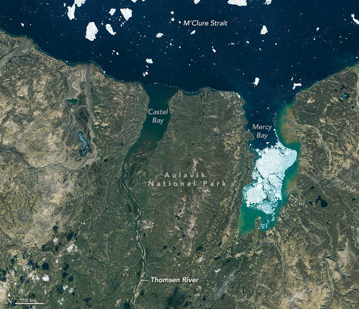
In a typical year, perhaps a dozen people visit Auluvik National Park in Canada’s Northwest Territories. Luckily, one of those visitors brought back some outstanding photos.
In November 2020, we highlighted a few compelling features around the Thomsen River estuary on Banks Island, including lines of sea ice tracing the shoreline and the braided pattern of the river. But there’s so much more to explore across this remote lowland tundra and river valley.
Robie Macdonald, a scientist at the University of Manitoba, shared some photos that he shot while doing fieldwork in the region between 2014 and 2016. The purpose of that project, led by Matt Alkire of the University of Washington, was to collect geochemical measurements from small rivers across the Canadian Arctic Archipelago.
“I really do love working in these places,” Macdonald said. “Once the aircraft has landed, one is bathed in a tremendous silence broken only by waves breaking on shingle. Then you have this incredible tundra spreading out toward the hills that define the river floodplain.”
Here are ten of Macdonald’s favorite photographs.
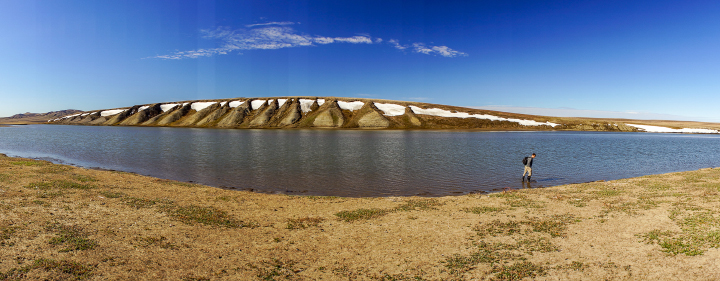
1. Ponds and Oxbows
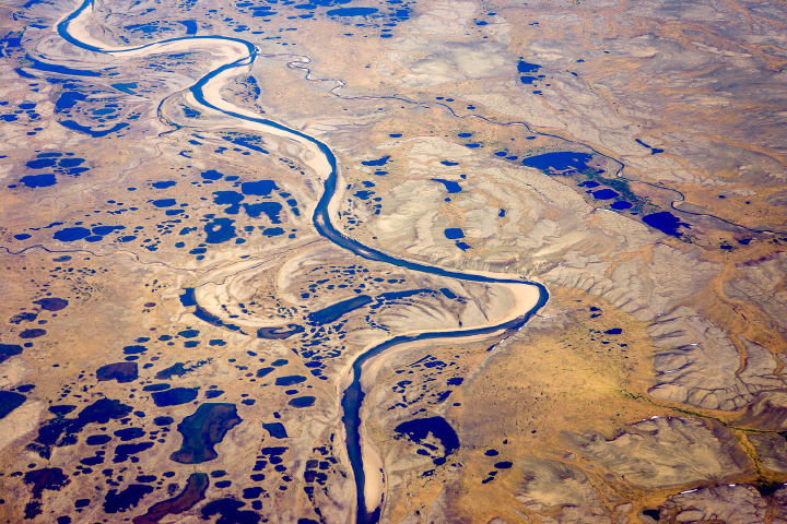
“Numerous ponds of all sizes populate the drainage basins of Banks Island, and you can see several clusters of them in the satellite image (top), especially along the small river to the west of the Thomsen. This photograph provides a closer look at one such pond cluster. In the image, you can also see textbook oxbows, which have become the setting for more ponds.”
2. Permafrost Polygons
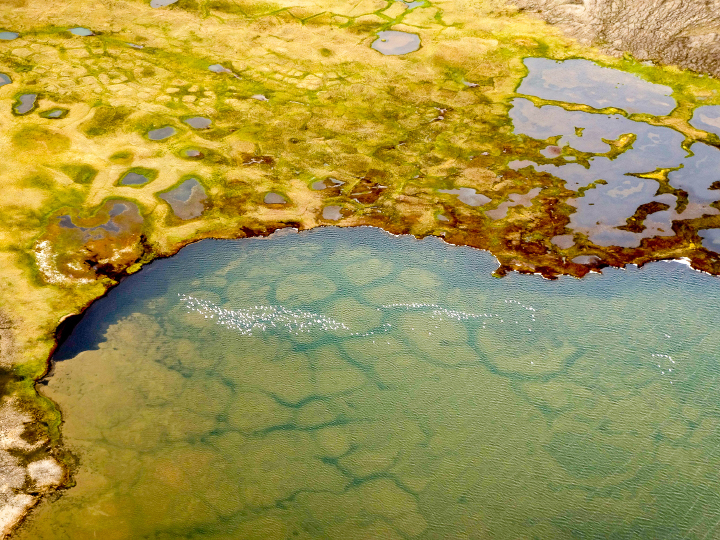
“During breeding season, it seems like almost every pond on Banks Island has its own population of snow geese (visible in this photo). You can also see old permafrost polygons that are now submerged within the pond. Polygons are widespread features of the permafrost in soil-rich locations and are produced over time by freeze-thaw cycles of the surface active layer. Permafrost thaw is widely impacting these regions, leading to feedbacks in the carbon system (CO2, CH4).”
3. Vibrant Vegetation
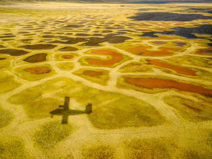
“Perhaps the most surprising characteristic of the valley bottoms in this ‘Arctic desert’ is the vibrant color of the vegetation: yellows, greens, and reds mark a dense ground cover that can be seen on the satellite image as areas with a yellowish-brownish cast.”
4. Sediment Ripples
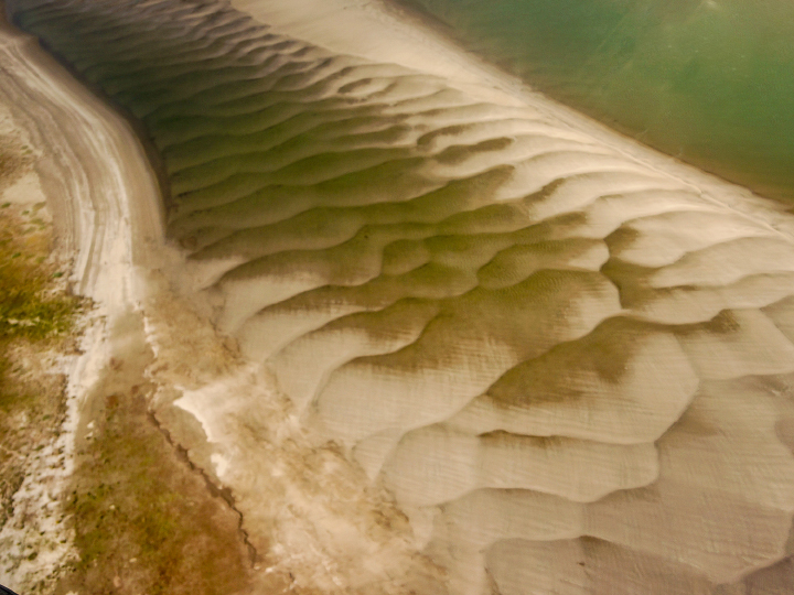
“As a result of the strong sediment supply, the large embayment at the Thomsen River mouth has been practically filled with sediment. The shallow water reveals itself in the satellite image by the lighter-greenish tone compared to water out in the channel north of Banks Island. More evidence of the ample sediment supply can be seen in beautiful displays of sand/silt ripples in the lower river between the islands. In the satellite image (top), the ripples are almost visible as grey zones between the islands before the river enters the open bay.”
5. Ice Shoves
“When walking on these islands near the river mouth, you can see evidence of bank erosion and ‘ice shoves.’ These are produced when wind forces newly formed ice to ride up over the river bank and gouge out the top layer of the silty material that makes up these islands. Unfortunately, ice shoves are too small to show on the satellite image.”
6. Vulnerable Permafrost
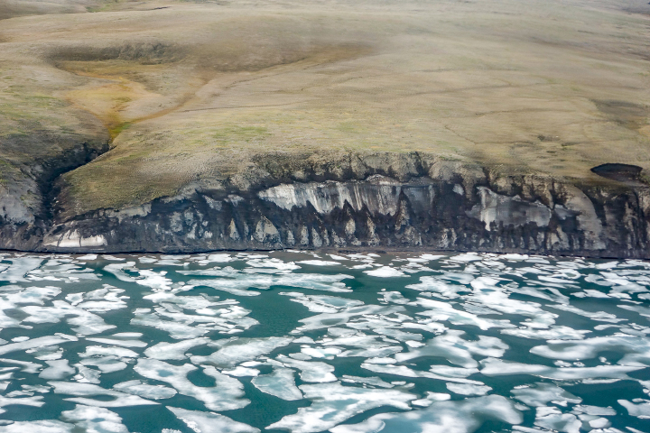
“Global warming and the extensive loss of sea-ice cover in late summer have helped accelerate coastal erosion and permafrost slumping. This image shows a section of coastline just to the east of the Thomsen River mouth that consists of a lot of frozen ice. This sort of permafrost is especially vulnerable to the changing temperature regime.”
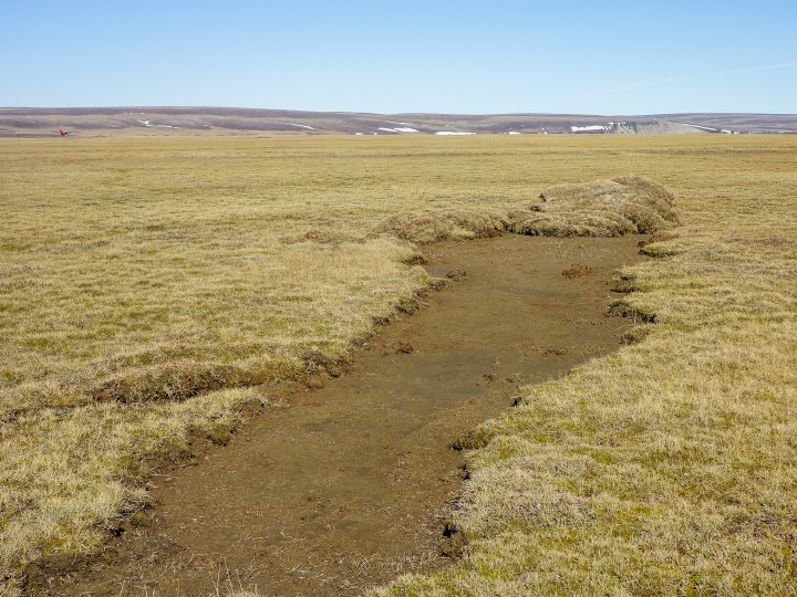
7. Erosion and Slumping
“Thaw slumps are also a sign of the permafrost warming. These can be seen just barely in the satellite image as small dark regions along cliff faces–both facing the ocean and within the river drainage basins. Erosion and slumping expose ancient organic carbon to the air and the hydrosphere, thus providing an extensive positive feedback to climate warming.”
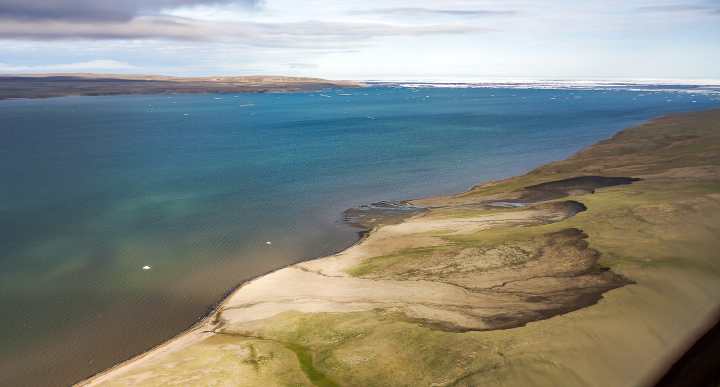
8. Bergy Bits
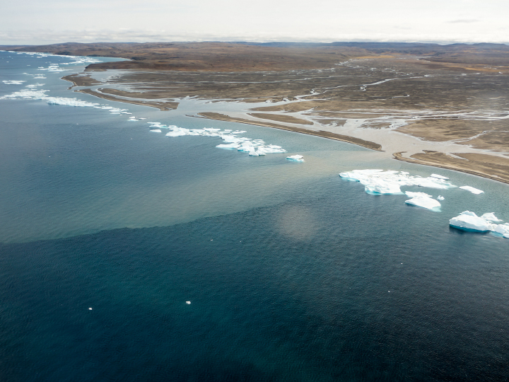
“Lines of bergy bits has collected along a thin shore margin at the point where the sea bottom rapidly deepens below ice keel depths, likely at approximately 2-4 meters. Although the grounded ice bits are continually melting, they are resupplied by more ice chunks shed from the permanent pack out in the channel. Two turbid plumes supplied by a river to the west of the Thomsen easily pass through the necklace of ice.”
9. Sampling Amid an Icy Barrier

“When we were sampling the water in this region, we found this ice barrier to be a bit more of a problem to navigate in our small inflatable boats, but ice along the shore did make it simple to sample sea ice. This image shows Greg Lehn preparing to launch our boat.”
10. A Suitable Landing Spot
Sampling in the Thomson River itself was somewhat simpler, once we had found a suitable place to land the plane. This image shows Greg Lehn scoping out the shore of the Thomsen River near its mouth.”
Current blog posts are true depiction of glacial geomorphology and resultant landscapes formed due to the surficial processes. Sedimentary structures are easily discernable along with syn-depositional slumping. The Operational Land Imager (OLI) capturing the natural-color image of Banks Island is very representative of the surficial record and the map scale provides a precise dimension of several features portrayed in this map.
How many of the ponds photographed are collapsed pingo’s? May be they could be detected by the ‘topsoil’ that moved from the top of the ice to the fringe? I live in an area (Netherlands) that was permafrost in the last ice age, 11.000 years BP. Fossil permafrost polygons and ice wedges can be seen in the subsoil, consisting of wind blown sands (cover sands) and/or boulder clay. We also have many fossil pingos in the area. They were filled with peat, that was used for fuel, so they are small lakes again, or they were filled up with soil and only minor depressions remain in cultured fields.
For me it is always very interesting to see (pictures of) the actual geological processes that we used to have here tens of thousand years ago.
Hi there; I’m probably not the best person to answer your question. I can say that pingos, like the one outside Tuk, were not overly obvious from a 7000′ flyover of Banks Island. A lot of the lakes are obviously associated with oxbows, which are prevalent in many locations due the meandering of the rivers over shallow slopes. But, Banks Island clearly has pingos, and I went to Google Scholar and found a number of studies relating to that – I’m pasting a couple below.
rob
Pingo investigations, north-central Banks Island, Canadian Arctic
and French, 1976, Canadian Journal of Earth Sciences
Volume 13, Number 7
1 July 1976
A number of pingo-like mounds, located in the north-central part of Banks Island, are described. The features are situated on low terraces within the valleys of the Thomsen River and its small tributary, Able Creek. Many are elongate in plan and partially collapsed in form. Sections excavated across four of the mounds reveal cores of massive ice. It is hypothesized that these ice bodies are the result of both segregation and injection processes, induced by the freezing of localized sub-channel taliks.
Genetically Complex and Morphologically Diverse Pingos in the Fish Lake Area of South West Banks Island, N.W.T., Canada
Stephen D. Gurney
Peter Worsley
First published: 10 December 2003
https://doi.org/10.1111/j.0435-3676.1997.00005.x
Ice cored mounds and patterned ground, southern Banks Island, western Canadian Arctic
HM French – Geografiska Annaler: Series A, Physical Geography, 1971 – Taylor & Francis
Attn: Robie Macdonald}
Thanks for posting these lovely photos of your fieldwork last summer! Since they are posted on the NASA Earth Observatory site, I’m supposing they are available for reuse?
With your permission, I’ll upload copies to Wikimedia Commons and use the standard NASA free license, unless you would like me to use another. I’ll credit you as photographer & University of Manitoba as your sponsor.
Thanks in advance,
Pete Tillman
http://en.wikipedia.org/wiki/User:Tillman
Here’s the LANDSAT index map for your field area, with out std NASA license:
https://commons.wikimedia.org/wiki/File:Thomsen_River_NWT.jpg