
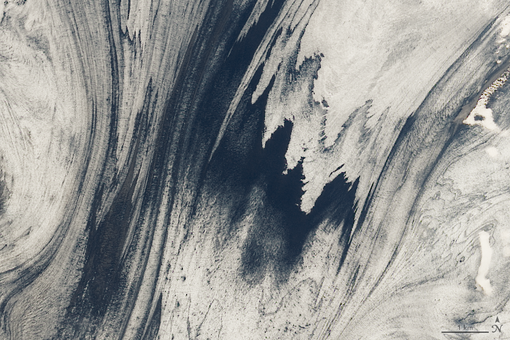
Every month on Earth Matters, we offer a puzzling satellite image. The January 2020 puzzler is above. Your challenge is to use the comments section to tell us what we are looking at, where it is, and why it is interesting.
How to answer. You can use a few words or several paragraphs. You might simply tell us the location. Or you can dig deeper and explain what satellite and instrument produced the image, what spectral bands were used to create it, or what is compelling about some obscure feature in the image. If you think something is interesting or noteworthy, tell us about it.
The prize. We can’t offer prize money or a trip to Mars, but we can promise you credit and glory. Well, maybe just credit. Roughly one week after a puzzler image appears on this blog, we will post an annotated and captioned version as our Image of the Day. After we post the answer, we will acknowledge the first person to correctly identify the image at the bottom of this blog post. We also may recognize readers who offer the most interesting tidbits of information about the geological, meteorological, or human processes that have shaped the landscape. Please include your preferred name or alias with your comment. If you work for or attend an institution that you would like to recognize, please mention that as well.
Recent winners. If you’ve won the puzzler in the past few months or if you work in geospatial imaging, please hold your answer for at least a day to give less experienced readers a chance.
Releasing Comments. Savvy readers have solved some puzzlers after a few minutes. To give more people a chance, we may wait 24 to 48 hours before posting comments.
Good luck!
See our “Iceland’s Volcanic Glacier” Image of the Day for the answer. Congratulations to Holger Wille for being the first reader to identify the location and offer a detailed explanation for what makes the area interesting.
Very informative! Article thanks for sharing with us
64°10’17″N 17°12’16″W · 2,726 ft
Iceland Skaftafell
Mix pint
Ice and, towards the right of the image, clouds over the ocean.
It looks to me to be cloud cover. The jet stream is pushing the clouds along the cause them to be more scattered and thin looking (example: left center side of pic).
Medial moraines within glacial ice, likely in Alaska, possibly Greenland, or Antarctica.
It is very interesting to see a mix of white and dark blue together. As Bill Norland says above, it does look like glacial ice somewhere up North. The glaciers are losing their ice, and the dark blue areas resemble the warmer waters that are carrying the ice chunks away. The different streaks of “lines” suggest the flow of the ice, that some parts of the glacier are melting at a faster rate than others. The event on the left side can be explained by land that squeezes the water and the ice into a tiny river, before expanding again.
Nevertheless of what the picture may be, it is very interesting because it makes us wonder about the beauties of our planet not just from the ground, but also from above. To really see these pictures of Earth from space allows us to remember how amazing and wonderful our planet is, and that we should protect it. It is no wonder that people in the past have called space “the Heavens”, and always wanted to reach for it. It is also no wonder that man has always wanted a view from above. It is also not a mystery that we should discover the amazing wonders of what we call Home.
It’s moraines carried by glacier. Location is Vatnajökull, the biggest continental glacier in Iceland. (64.1699835N, 17.1791307W)
Icelandic glacier with bands of volcanic ash (presumably one of the extensions of the large Vatnajökull glacier).
Seeing this i thinks of greenland, alska northern pole or some what like antarctika….
That big piece of orbiting driftwood nobody noticed before because it is usually transparent.
Moraines or ogives in a mountain glacier, from SAR backscatter image.
it is a ice on Greenland.
Me gusta mucho conocer todo de nuestro planeta, su flora y fauna y los tipos de rocas de que está formada la tierra donde vivimos, pero en realidad me gusta saber de todo o casi todo como es y por qué es así y que se puede aprender de la naturaleza. Creo que con ustedes se aprende mucho.
Breiðamerkurjökull glacier near Iceland’s Glacial Lagoon (Jökulsárlón)
A nice shot of the medial moraines on Skeiðarárjökull in Vatnajokull National Park in Iceland. Glacial outburst floods (Jökulhlaup) from here flow across the Skeiðarársandur floodplain before reaching the ocean causing damage to the Ring Road and its bridges
The location of this image may be in Antarctica. Spectral band 7 could have been used. The ice or snow of this location is somewhat being blown away thus causing the image to look as if it is moving. Snow could be moving in different directions as well.
It must be a wind blown ash