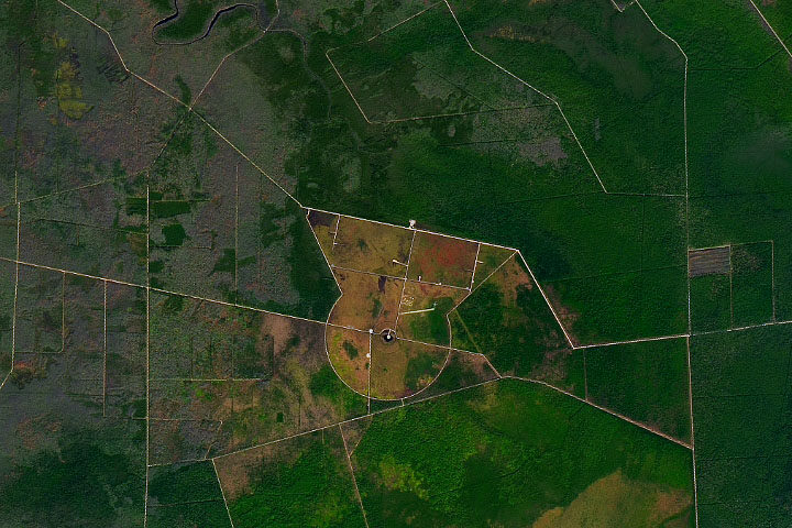
Every month on Earth Matters, we offer a puzzling satellite image. The December 2019 puzzler is above. Your challenge is to use the comments section to tell us what we are looking at, where it is, and why it is interesting.
How to answer. You can use a few words or several paragraphs. You might simply tell us the location. Or you can dig deeper and explain what satellite and instrument produced the image, what spectral bands were used to create it, or what is compelling about some obscure feature in the image. If you think something is interesting or noteworthy, tell us about it.
The prize. We can’t offer prize money or a trip to Mars, but we can promise you credit and glory. Well, maybe just credit. Roughly one week after a puzzler image appears on this blog, we will post an annotated and captioned version as our Image of the Day. After we post the answer, we will acknowledge the first person to correctly identify the image at the bottom of this blog post. We also may recognize readers who offer the most interesting tidbits of information about the geological, meteorological, or human processes that have shaped the landscape. Please include your preferred name or alias with your comment. If you work for or attend an institution that you would like to recognize, please mention that as well.
Recent winners. If you’ve won the puzzler in the past few months or if you work in geospatial imaging, please hold your answer for at least a day to give less experienced readers a chance.
Releasing Comments. Savvy readers have solved some puzzlers after a few minutes. To give more people a chance, we may wait 24 to 48 hours before posting comments.
Good luck!
See our “Peninsula of Pocosin” Image of the Day for the answer. Congratulations to Suryakant Verma and Sander Clement for being the first readers to identify the location and offer a detailed explanation for what makes the area interesting.


Laid out with military or scientific precision. The vegetation has been cleared from the surrounding forest. The structures barely cast a shadow so they must be short. I’m guessing a radar or telescope installation.
Ps, love your work, Cheers.
Abandoned missle silo.
This is a total guess. Maybe it is an old missile silo due to the well-defined road shaped in a circular pattern. It is interesting because of the small amount of vegetation in the circular area, and lots of vegetation outside the immediate circle. It looks like it is located in a plains state, as the roads are angular for the most part. And what is that red area?? Thank you!
We are looking at Dare County Bombing Range which is surrounded by Alligator River Wildlife National Refuge in North Carolina. Its a place for bombing and gunnery training for U.S. Air Force, Navy, Marin Corps and Air National Guard. An uncontrolled Forest fire scroched around 7000 acres of land in year 2011. Its an environment sensitive area and conservation of flora and fauna is very much important.
Military bomb practice field.
this is where you turn up the volume of the earth, in db.
your angel is just a little off…
Alligator River Wildlife Refuge, North Carolina. because: 1 – The soil and tree cover patterns show it is a wetland, probably coastal, as there is a tidal creek on top. 2 – The colours of soil and vegetation show a warm climate. 3 – The area has a rational and functional allotment, usually only found in Europe or USA. 4 – Picture is shared by NASA. 1+2+3+4 combined limits the possibilities to specific area, i scanned them in google maps and found the location. – The clearcut area in the center suggest some sort of military use in the past. I would guess a radar or radio tower in the middle of the perimeter. However a further study of Google Maps suggest this may be a airforce shooting range. There are MIG dummy’s parked on the light greenish strip in the open top part of the circle. It could have been used by the Navy Harrier Squadron, because there was heavy ammunition stacked in one of the concrete slab area’s. The only airplane that could get there for attachment of these was the Harrier. The central point could have been a watchtower to asses the activities. (I used no other sources then google maps, i think a lot more could be found if i tried to google this)
former (abandoned) irrigation of agriculture land (pasture). Or simply forest restoration.
Moto Grosso Brasilia.
Looks like some (sub-)tropic forest (south America or Africa) with lots of roads. The circle shape in the middle (with clear-cuts) could be meant for a settlemant.
It is look like a secure area, in the center there is a some type of tower or antenna for signal broadcasting and the circle is like a boundary.