
Every month on Earth Matters, we offer a puzzling satellite or aerial image of Earth. The July 2018 puzzler is above. Your challenge is to use the comments section to tell us what we are looking at and why this place is interesting.
Bonus question: Is this landscape part of the tropical climate zone, subtropical zone, temperate zone, or polar zone? Why?
— NASA Earth (@NASAEarth) July 24, 2018
How to answer. You can use a few words or several paragraphs. You might simply tell us the location. Or you can dig deeper and explain what mission produced the image, what instrument was used to create it, or what is compelling about some obscure feature in the image. If you think something is interesting or noteworthy, tell us about it.
The prize. We can’t offer prize money or a trip to Mars, but we can promise you credit and glory. Well, maybe just credit. Roughly one week after a puzzler image appears on this blog, we will post an annotated and captioned version as our Image of the Day. After we post the answer, we will acknowledge the first person to correctly identify the image at the bottom of this blog post. We also may recognize readers who offer the most interesting tidbits of information about the geological, meteorological, or human processes that have shaped the landscape. Please include your preferred name or alias with your comment. If you work for or attend an institution that you would like to recognize, please mention that as well.
Recent winners. If you’ve won the puzzler in the past few months or if you work in geospatial imaging, please hold your answer for at least a day to give less experienced readers a chance to play.
Releasing Comments. Savvy readers have solved some puzzlers after a few minutes. To give more people a chance to play, we may wait between 24 to 48 hours before posting comments.
Good luck!
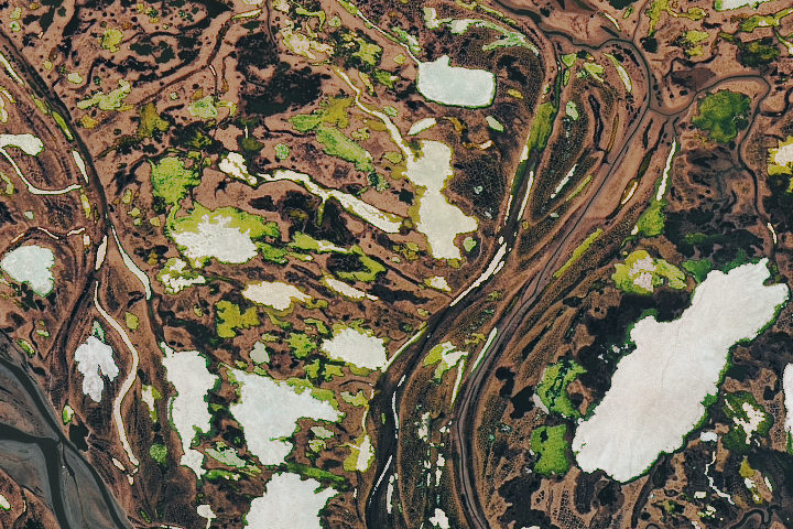
Answer: The Operational Land Imager (OLI) on Landsat 8 acquired this image of the swampy, bog-filled terrain of the Yana River Delta in northern Russia on June 18, 2018. Read more about it on our July 28, 2018, Image of the Day.
it is of a city landscape in the USA.
Yukon River, Alaska
mississippi river delta
This used to be such a user-friendly, easy to navigate site. It’s now so frustrating to use that I rarely visit any more. Adios. 🙁
Looks like stream meanders over permafrost, somewhere in the Arctic. The white patches look like snow, so along with the greening, it could be the June thaw. And I think I see several patches of tundra polygons resulting from continuous freezing and thawing of the surface soils.
answer is temperate zone
white reveal to clouds
green to plants
brown to soil (land)
Yukon Delta National Wildlife Refuge.
Sustina river delta Alaska and the white bits are lakes.
As to the first question — I think others have already answered that it is a part of the Yukon delta. This is a likely choice, although possibly other high latitude river deltas could be the ones in the photograph.
As to the other (twitter) question — I would say that it is high latitude temperate. At that latitude it would be a matter of how one defines polar/temperate. Several areas have a high albedo, indicating that either snow/ice is present or potentially salt is present. This does not look like the typical saline area, so I would say it is in an area that freezes. The green indicates that it might be spring/summer with melting (rather than freezing) ice, as autumn colors would be ruddier. The Yukon delta would not be within the polar circle (approximately 66 degrees N). This would mean that technically it is not polar, although it might be within an area that has permafrost. With global warming, however, the permafrost may not exist. So depending on whether you define polar in ecosystem terms or in astronomical terms, it might be either temperate or polar. . .
Looks like Laos where the dam burst
Dallol Volcano and Hydrothermal Field Ethiopia
Definitely a river basin in Canada or other polar region. I think it is indicating methane emission from the lakes.
Irkut River Delta in Russia / Mongolia
The image come from Greenland .
In my opinion, it is a great arctic flood plain, between two stretches of rivers, braided, like the one in the lower left, or anastomosed, like the rest.
The white areas would be frozen lakes, over the permafrost, at the beginning of the thaw season. The green tones could be the thawed parts of the lakes where algae blooms are taking place.
I am not able to identify the exact site, but it could be any area of a large Arctic river, such as the Mackenzie, Yukon, in North America or even some Siberian river as the Obi, Yenisei or Lena.
It’s a tropical region with forest
I think it’s a tropical region. there we can see a river, plants and trees, white patches look like cumulus, but I think it’s snow.