
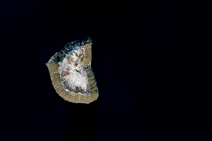
Every month on Earth Matters, we offer a puzzling satellite image. The January 2018 puzzler is above. Your challenge is to use the comments section to tell us what we are looking at, when the image was acquired, and why the scene is interesting.
How to answer. You can use a few words or several paragraphs. You might simply tell us the location. Or you can dig deeper and explain what satellite and instrument produced the image, what spectral bands were used to create it, or what is compelling about some obscure feature in the image. If you think something is interesting or noteworthy, tell us about it.
The prize. We can’t offer prize money or a trip to Mars, but we can promise you credit and glory. Well, maybe just credit. Roughly one week after a puzzler image appears on this blog, we will post an annotated and captioned version as our Image of the Day. After we post the answer, we will acknowledge the first person to correctly identify the image at the bottom of this blog post. We also may recognize readers who offer the most interesting tidbits of information about the geological, meteorological, or human processes that have shaped the landscape. Please include your preferred name or alias with your comment. If you work for or attend an institution that you would like to recognize, please mention that as well.
Recent winners. If you’ve won the puzzler in the past few months or if you work in geospatial imaging, please hold your answer for at least a day to give less experienced readers a chance to play.
Releasing Comments. Savvy readers have solved some puzzlers after a few minutes. To give more people a chance to play, we may wait between 24 to 48 hours before posting comments.
Good luck!
Tags: puzzler
That looks like the top of a volcano–cone shaped with sunken middle–must be on a coast line with water to the northwest Is it the volcano that erupted in the Philippines?
Is it snow in Hawaii?
This appears to be a small volcanic island with a rather large caldera and a fair amount of snow/ice.. Right side is flat due to tectonic activity. I’d guess this is probably somewhere along the mid-Atlantic ridge in the vicinity of Iceland.
That’s Little Diomede Island, off Alaska. Its big brother, Big Diomede Island is across the International Date Line and part of Russia.
It is Little Diomede Island, Alaska in the Bering Strait!
Fun Fact – Diomede Island is only a few miles away, but part of Russia, and on the other side of the international date line.
Grimsy, north of Iceland
A volcanic caldera in the middle of the ocean?
It looks like a new island, perhaps? Like Nishinoshima in Japan? Maybe not that specific one (though it could be — it didn’t look like that last time I saw a picture of it, but I know it’s always growing), but somewhere nearby.
An island with a crater.
That’s Little Diomede Island, on the US side of the maritime border between Russia and Alaska.
A broken piece of meteorite passed under the lens of the camera when it was pointing away from earth
Forgot to add that the International date line runs between Little and Big Diomede Islands.
This is Little Diomede Island in the Bering Strait between Alaska and Siberia. While this island is on US territory, Just a few miles to the west is Big Diomede Island, which is in Russia on the opposite side of the International Date Line.
Little Diomede Island otherwise known as Yesterday Island
It appears to be a small / relatively new volcanic island
It appears to be a crater on earth formed by an asteroid that hit the earth around 50,000 years ago. What might make it interesting is the location and how it has changed over the most recent years and is possibly the Lonar crater in Maharashta, India. It had produced a glass-like substance when it had first hit from high impact velocity. This image was captured by the Advanced Spaceborne Thermal Emission and Reflection Radiometer on NASA’s Terra satellite.
Little Diomede Island! Very cool photo. Most interesting because this is where you really can see “Russia from my backyard!” Big Diomede Island is Russian territory and is only 2.5mi away 🙂 Furthermore, it’s on the other side of the international date line, so when you look at the Big Diomede Island, you’re looking into the future!
I think it is a small volcano, island.. new born island, table shaped.
.. location..? ..
I believe the sat image is likely cobwebs from spiders.
Saba in the Caribbean
This is the satellite image of Saba
It looks like a volcanic island in the ocean. It must be in a high latitude N or S because of the snow covering the rim and the part of the island which is in the shadow. Inside the crater we can see red areas that can be lava. Snow covered the interior of the crater because the sun illuminates it less than the flanks.
Regards
its a mountain peak on a island. on maps, north is usually up, and much of the run off is headed that way yet it seems to be shaded. My guess is the island is in the southern hemisphere and the picture was taken when it was summer at this island.
Ice curtain, little diomede
This is a volcanic island very much like the Hawaiian chain of islands. The snow cover indicates it is winter. When it is winter and the sun shines from the south, it indicates that the island is in the northern hemisphere. The presence of snow in the caldera and the coastal area indicates high latitudes.
There are more gullies on the east and northwest slopes. This probably means the island is around 60 degrees north. The lack of heavy cover of vegetation also indicates the higher latitudes.
Possibly an island in the Amundsen Gulf, northern Canada. The island to the west of the Adelaide penisula.
water deposit(s) under crust showing ancient presence of oceans in Mars (also in Saturn moon?)
Little Diomede in the Bering Strait. Not sure what shot it but it looks like visible spectrum to me.
Little Diomede Island in Bering Strait between mainland Alsaka and Siberia; located at the International Date line border, and the international border between Russia and USA.
Little Diomede Island is owned by USA and the Big Diomede island is owned by Russia.
the two islands are about 3.8 Km apart , Big Diomede is 23 hours ahead of little Diomede.
the islands are sometimes nicknamed Tomorrow island and yesterday island.
The image is little Diomede island (USA)
.Maybe the photo is taken in autumn,just before the ice in the sea. At 3km there is the other island that belongs to Russia.
A volcanic island. Covered in snow.
Little Diomede Island, virtually on the international date line, and presumably the closest US settlement to Russia.
Looks like an island caldera. Maybe somewhere around Greenland or Russia? My guess is it’s either new-ish land or its sitting in a funny spot that makes it special.
neanderthal DNA found at numerous grave sites
Little Diomede Island at 65*45′ 10.90″ N – 168 *55′ 26.39 ” W
Located : SE of Big Diomede Isaland In the Bering Strait .
Sats : possibly : Geoeye-1 ..Digital globe World View-2.. or one of three SPOT sats
Formerly known as Krusenstern Island..Little Diomede retains a permanent native population. As of the 2010 census, Little Diomede had a population of 110, down from its recorded peak of 178 in 1990.According to the United States Census Bureau, the island has a total area of 2.8 square miles (7.3 km2), all of it land. On the western shore of the island is the village of Diomede, also known as Iŋaliq.The Little Diomede island is composed of Cretaceous age granite or quartz monzonite
The highest point on Little Diomede Island is 494 meters (1,621 feet)
Summer temperatures average 40 to 50 °F (4–10 °C).
Winter temperatures average from 10 to 6 °F (−12 – −14 °C)
source site : Wiki
I think it is Fernandina Island (Galapagos). It was in the news in September (September 5, 2017) because it erupted (volcano) — the first eruption on Fernandina since 2009.
Little Diomede Island, Alaska. This island sits in the Bering Strait and sits on the edge of US border with Russia. It’s neighbor, Big Diomede Island, is located to the west, residing in Russia. The strait lying between Little Diomede and Big Diomede was known as the Ice Curtain during the Cold War.
Google Maps link:
https://www.google.com/maps/place/65%C2%B045'24.3%22N+168%C2%B055'18.0%22W/@65.7567494,-168.9562369,8049m/data=!3m1!1e3!4m14!1m7!3m6!1s0x5f34d20b9d5500c3:0x458086c4fef4bfb1!2sUshishir!3b1!8m2!3d47.5263889!4d152.8191667!3m5!1s0x0:0x0!7e2!8m2!3d65.7567548!4d-168.9216623
No! I was wrong! It looks as though it might be Little Diomede Island (near Big Diomede Island) in the Bering Strait. Am I allowed to change my entry? Hopefully yes, since my previous comment is awaiting moderation. Little Diomede is known for being within easy reach of Russia (Big Diomede Island). It has a small permanent population. It is supposedly a remnant of a former landbridge between Asia and North America. It is not volcanic and is a block formation.
This is Little Diomede Island in Alaska and just east of Russian Big Diomede. It must have been taken in June when the sea ice is gone but snow from the previous winter remains. It’s the one place you can truly see Russia from the U.S.
Little Diomede Island Alaska
Not sure what it is, however it Might be a new are you in Hawaii
Mountain with ice or (glacier) fresh water river one side
Thanks to all who determined it’s Little Diomede Island in Alaska’s Bering Strait. The reason it’s astonishing is that there’s no sea ice in the photo, despite it being far into the winter.
Indian ocean or the great southern ocean can’t remember name.
these are electrochemical reactions which produced ele.ions.
Space junk…
When will you post the answer? Waiting…
Looks like a meteorite sectioned in half.
Looks like a broken geode.