
In this satellite image, the prominent Pinacate Peaks stick out above the sand dune landscape of the Gran Desierto de Altar in Mexico’s Sonoran Province. The peaks are located just south of the Mexico-United States border. The Gran Desierto de Altar is one section of the broader Soronan Desert which covers much of northwestern Mexico and reaches into Arizona and California.
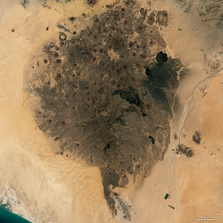
Steady, consistent winds in the area have shifted low-lying sand into dune fields in intriguing regular patterns. These same patterns of sand dune fields appear around the world in desert areas.
The volcanic peaks and cinder cones are believed to have formed from volcanic activity that first started roughly 4 million years ago — most likely due to the plate tectonics that also formed the Gulf of California around the same time. The most recent activity was perhaps 11,000 years ago. During the late 1960s, NASA trained astronauts in field geology at a number of sites around the world, including Pinacate Peaks, as preparation for the lunar landings.
The natural color image here is from the Landsat 8 satellite using its Operational Line Imager (OLI) instrument. The image was acquired on October 3, 2017. The volcanic cinder cone field stains the landscape of bright sand and tall dunes in the El Pinacate y Gran Desierto de Altar Biosphere Reserve.
NOTE: In a previous version of this post, I featured the EO-1 ALI image below, and an astute reader pointed out that these peaks, while in the Biosphere Reserve, are not Pinacate Peaks, but rather the Sierra de Rosario range nearby. I am geographically and tectonically embarassed…
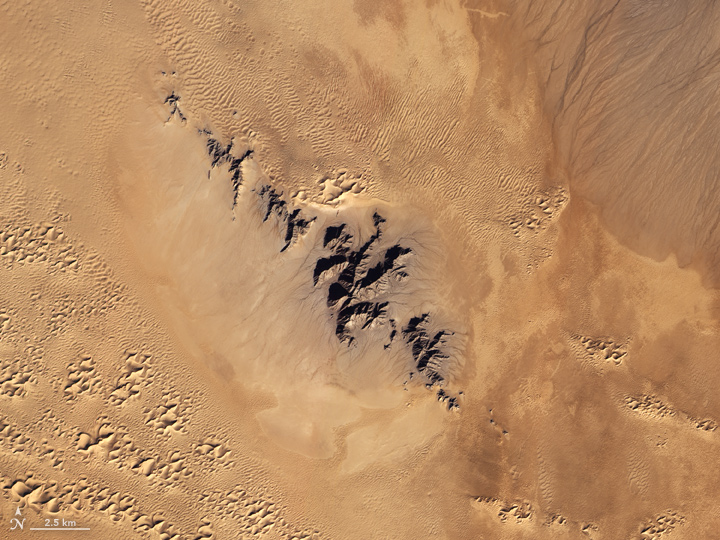
The natural color image here is from the now-defunct Earth Observing 1 (EO-1) satellite using its Advanced Land Imager (ALI). The image was acquired on December 16, 2012. This late-year scene was just days before the solstice (the farthest south the Sun appears in the sky), so the tallest sand dunes and the volcanic peaks cast unusually long shadows across the ground.
EO-1 was launched in November 2000 as an engineering testbed for new sensor technology; in particular, the ALI instrument was a predecessor for the Landsat 8 Operational Land Imager. The EO-1 mission was so successful that it was extended past its original 18-month mission, and was only recently retired after 17 years of operation.
Thanks for sharing this, Jesse! It reminds me of a lovely book about the geologic AND human history of the Pinacate region: Desert Heart by William K. Hartmann.
Definitely a very nice remembrance to me of my teen ages, as a young boy I enjoyed reading the book
-Carrying the Fire- by Michael Collins in which was published a picture of those Astronauts of the Apollo program during training at Reserva del Pinacate in Sonora State , I still keep that book with me through the years, it is one of my most valuable belongings, now being enjoyed by my sons.
Later through the years as an Airline Pilot I flew countless times the western Mexico air routes that took us each time over El Pinacate along the J5 airway, and each time my eyes, my mind and my senses went down to the view of those mountains and that desert to imagine that training and that adventure that gave the astronauts great knowledge needed to endure his cosmic out of this world adventure,
Thanks for sharing this great picture , made me feel again those flights dreaming on the outer space voyages.
Luis
Beautiful photo, but it’s not the Sierra Pinacate that’s in the image. That’s the Sierra de Rosario, a stark granitic range about 40 km to the northwest of the Pinacate volcanic field. The mountains are surrounded by the dunes of the Gran Desierto de Altar but local wind patterns have swept most of the perimeter clean…unlike the nearby Sierra Enterrada (“buried peaks”) which are nearly swallowed by the sea of sand. The dunes of the Gran Desierto contain the only active star dunes in North America and the complex to the north of the mountain range is nearly 150m above the desert floor.
This is one of the hottest and driest places on the continent. Summer highs can reach 45 degrees and sometimes years can pass in a given spot without measurable rainfall. When the rains do arrive, the dunes burst with color in a riot of wildflowers: verbena, poppies, lilies and the curious parasitic plant known as sandfood (Pholisma sonorae), which was a staple of the Hia C-ed O’odham people living in the region.
The Sierra de Rosario is also home to numerous plants and animals, such as the twisted elephant trees, related to frankincense, and the occasional band of desert bighorn. Near the top of the ridge, in a north-facing ravine where a little extra moisture can persist, I found in 1996 what I believe to be the most remote individual saguaro cactus, thriving and looking as robust as its cousins in the comparatively lush desert 100 km to the east.
Phil