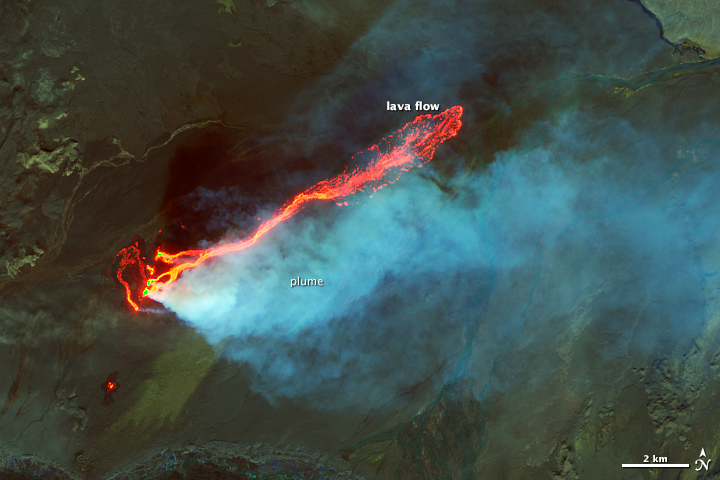


Every month we offer a puzzling satellite image, and the November 2014 puzzler is above. Your challenge is to use the comments section to tell us what part of the world we are looking at, when the image was acquired, what the image shows, and why the scene is interesting.
How to answer. Your answer can be a few words or several paragraphs. (Try to keep it shorter than 200 words). You might simply tell us what part of the world an image shows. Or you can dig deeper and explain what satellite and instrument produced the image, what spectral bands were used to create it, or what is compelling about some obscure speck in the far corner of an image. If you think something is interesting or noteworthy, tell us about it.
The prize. We can’t offer prize money but we can promise you credit and glory (well, maybe just credit). Roughly five days after a puzzler image appears on this blog, we will post an annotated and captioned version as our Image of the Day. In the credits, we’ll acknowledge the person who was first to correctly ID the image. We’ll also recognize people who offer the most interesting tidbits of information about the geological, meteorological, or human processes that have played a role in molding the landscape. Please include your preferred name or alias with your comment. If you work for or attend an institution that you want us to recognize, please mention that as well.
Recent winners. If you’ve won the puzzler in the last few months or work in geospatial imaging, please sit on your hands for at least a day to give others a chance to play.
Releasing Comments. Savvy readers have solved some of our puzzlers after only a few minutes or hours. To give more people a chance to play, we may wait between 24-48 hours before posting the answers we receive in the comment thread.
Good luck!

On September 6, 2014, the Operational Land Imager (OLI) on Landsat 8 captured this view of the eruption.
In some ways, the ongoing fissure eruption at Holuhraun lava field in Iceland is an ideal one. Unlike the lava pushing through the Hawaiian village of Pahoa, Holuhraun’s lava is nowhere near any towns or villages. And the eruption has had little effect on air traffic–unlike the Eyjafjallajokull eruption in 2010--because Holuhraun has produced little of the volcanic ash that can damage propellers and gum up engines.
What Holohruan has produced in vast quantities is lava. As a stream of eye-popping field videos—and satellite images—have shown, lava has gushed from Holuhraun almost continuously since late August. Now covering more than 70 square kilometers and filling a volume of one cubic kilometer, Holuhuraun has proven to be Iceland’s largest effusive eruption since 1784.
Holohruan also has been a reliable source of sulfur dioxide, a colorless but toxic gas present within magma. In addition to triggering health problems if inhaled, sulfur dioxide can lead to acid rain and it can react with other substances in the air to produce sulfate aerosols that cool the atmosphere by deflecting sunlight.
Fossil-fuel burning releases sulfur dioxide, but volcanoes do so on a grander scale. Nature reported that an average of 35 tonnes of sulfur dioxide are streaming from Holohuraun each day, more than twice the amount that all of Europe’s factories produce in the same period. “Those levels of sulfur dioxide emissions are quite typical—even low—for an erupting volcano,” said Simon Carn, a volcanologist at Michigan Technological University. “The most interesting aspect of the Holuhruan eruption is its duration. It could go on from months, so the total sulfur dioxide emissions could end up being large.”

For a sense of the daily ebb and flow of sulfur dioxide emission, see the chart above, which is based on observations from the Ozone Monitoring Instrument (OMI) on NASA’s Aura spacecraft. The image below shows OMI’s observation of a sulfur dioxide plume drifting over Iceland on September 4, 2014, one of the days the sensor observed a peak in sulfur dioxide emissions. High concentrations of sulfur dioxide are shown in red.
In at least one case, gases from Holuhruan have entered the atmosphere with remarkable style. On September 3, engineers with Nicarnica Aviation were monitoring the eruption from the ground with an infrared camera. The camera is designed to detect ash, but they ended up capturing a view of something unusual: a spiraling plume that was likely dominated by sulfur dioxide and other gases. The structure was reminiscent of a dust devil, a small, rotating column of air that forms when one part of a surface heats up much faster than the surrounding area.
In the video below, colors correspond to the temperatures observed by the camera. Red depicts the hottest temperatures, yellow moderate temperatures, and blue the coolest. “The general mechanism is probably the same as that for dust devils, but in this case the funnel is most likely filled with sulfur dioxide, gas, and volcanic ash,” Prata told New Scientist.

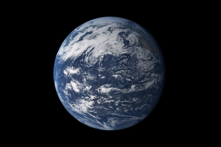
Maybe you have heard people call Earth “the water planet.” The nickname is well-deserved. As this mosaic of images from the Moderate Resolution Imaging Spectroradiometer (MODIS) on the Terra satellite conveys so well, the majority of Earth’s surface is covered by either liquid or frozen water. The atmosphere is awash with water as well. One satellite-based data set estimates that about 60 percent of Earth’s surface is covered by clouds (composed of water and ice droplets) at any given time.
Earth is home to yet another type of water—groundwater—which includes all the fresh water stored underground in soil and porous rock aquifers. Though groundwater is often forgotten because it’s not visible, more than two billion people rely on it as their primary water source.
With drought afflicting several parts of the world, and with aggressive use of groundwater in many agricultural regions, this precious water resource is under serious strain, warns NASA Jet Propulsion Laboratory hydrologist James Famiglietti. In a commentary published by Nature Climate Change in October 2014, Famiglietti wrote:
In many parts of the world, in particular in the dry, mid-latitudes, far more water is used than is available on an annual, renewable basis. Precipitation, snowmelt, and streamflow are no longer enough to supply the multiple, competing demands for society’s water needs. Because the gap between supply and demand is routinely bridged with non-renewable groundwater, even more so during drought, groundwater supplies in some major aquifers will be depleted in a matter of decades. The myth of limitless water and the free-for-all mentality that has pervaded groundwater use must now come to an end.
Most of the major aquifers in the world’s arid and semi-arid zones—the parts of the world that rely most heavily on groundwater—are experiencing rapid rates of depletion because of water use by farms. As shown in the chart above—based on data collected by the Gravity Recovery and Climate Experiment (GRACE)—this includes include the North China Plain, Australia’s Canning Basin, the Northwest Sahara Aquifer System, the Guarani Aquifer in South America, the High Plains and Central Valley aquifers of the United States, and the aquifers beneath northwestern India and the Middle East.
The situation is looking particularly grim in California, a state currently suffering from extreme drought. The extent of the drought is visible in the series of GRACE maps of dry season (September-November) water storage anomalies shown below. Red areas show the height of the water in comparison to a 2005-2010 average. California’s Sacramento and San Joaquin river basins have lost roughly 15 cubic kilometers (4 cubic miles) of total water per year since 2011 — more water than all 38 million Californians use for domestic and municipal supplies annually. Over half of the water losses are due to groundwater pumping in the Central Valley, according to Famiglietti.
The first step to managing the globe’s groundwater problem is to accept that we have one, Famiglietti recommends. And when societies are ready to look for solutions, the first place they’ll have to turn is the agricultural sector. “Agriculture accounts for nearly 80 percent of water use globally, and at least half of the irrigation water used is groundwater,” he wrote. “Even modest gains in agricultural efficiency will result in tremendous volumes of groundwater saved, or of water available for the environment or other human uses such as municipalities, energy production, industry and economic growth.”
Read the full commentary here. You can read news reports about Famiglietti’s article from Mashable, the Financial Times, and Discovery News. Read more about observing groundwater from space in “The Gravity of Groundwater.” Watch Famiglietti give a TEDx talk about groundwater losses below.
http://youtu.be/SejRgVhsT7c