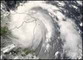
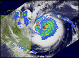
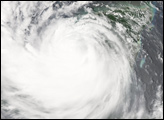
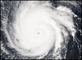
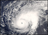
Category 5 hurricanes are rare. Rarer still is the storm that makes landfall as a Category 5 storm—most weaken before hitting land. Yet, exactly two weeks after Hurricane Dean struck the Yucatan Peninsula as a Category 5 storm (the first Atlantic storm of that size to come ashore since Hurricane Andrew in 1992), Hurricane Felix roared ashore at Category 5 strength. Felix came ashore over northeastern Nicaragua on September 4, 2007, with sustained winds of 260 kilometers per hour (160 miles per hour), said the National Hurricane Center. Forecasters predicted that Felix would continue to move west over Honduras, El Salvador, Guatemala, and Mexico. Heavy rain in these mountainous regions could trigger devastating floods and mudslides.
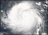
The Moderate Resolution Imaging Spectroradiometer (MODIS) on NASA’s Aqua satellite captured this image of Hurricane Felix at 12:30 p.m. local time (18:30 UTC) on September 3, 2007. At that time, Felix had already reached Category 5 status, with wind speeds that matched those observed at landfall the following morning. Along the left side of the image is the Central American coastline where Felix would eventually come ashore. The image reveals that Felix was compact, not a sprawling storm, and densely packed with bright clouds. Though cloud-filled, the eye forms a small, dark depression in the center of the storm.
The large image provided above has a resolution of 250 meters per pixel, MODIS’ maximum resolution. The image is available in additional resolutions from the MODIS Rapid Response System.
You can download a 250-meter-resolution KMZ file of Hurricane Felix suitable for use with Google Earth.
NASA image created by Jesse Allen, using data provided courtesy of the MODIS Rapid Response team.