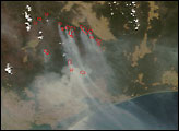
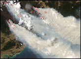
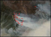
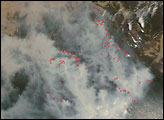
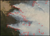
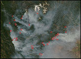
Clouds had been hiding Victoria from the view of the Moderate Resolution Imaging Spectroradiometer (MODIS) on NASA’s Terra and Aqua satellites in previous weeks, but when the skies cleared on January 10, 2007, it was obvious that fires that had been burning in the area since early December 2006 were still raging. Places where Terra MODIS detected actively burning fires are outlined in red. Rivers of smoke pour from the burning vegetation.
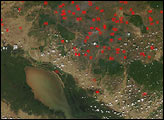
Although vegetation in this dry part of the world doesn’t appear as vibrantly green as forests in wetter parts of the world, there is nevertheless a clear difference between forests that have burned and those that have not burned (or were lightly burned). The unburned areas appear dark green, while the burned areas appear brown. A huge swath of the Great Dividing Range Mountains between Lake Eildon and the town of Omeo burned in late 2006 and early 2007. The fires may continue for several months.
The high-resolution image provided above has a spatial resolution of 250 meters per pixel. The MODIS Rapid Response Team provides twice-daily images of the area in a variety of resolutions and formats, including an infrared-enhanced version that makes the burn scar more obvious.
A 250-meter-resolution KMZ file of the Victorian fires is available for use with Google Earth.
NASA image courtesy the MODIS Rapid Response Team, Goddard Space Flight Center.