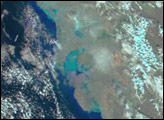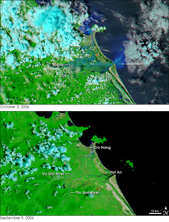
Typhoon Xangsane slammed into the coast of Vietnam on October 1, 2006, pounding the coastal city of Da Nang with sustained winds of 150 kilometers per hour (90 miles per hour) and heavy rain. The storm moved west over Laos, Cambodia, and Thailand, and by October 3, the clouds had cleared enough to give the Moderate Resolution Imaging Spectroradiometer (MODIS) on NASA’s Aqua satellite a view of the hard-hit Vietnam coast. The image, top, reveals that Xangsane left extensive flooding in its wake. The land between the Vu Gia River and the Thu Bon River is covered with water. Mud gives the water on land its pale blue color in contrast to the dark blue and black seen in the ocean. As the sediment-laden water empties into the ocean, it pours a cloud of sediment into the ocean. The sediment creates the bright blue fan along the shore and in the bay near Da Nang. Though flooding isn’t visible in Da Nang itself, the sediment in the bay suggests that the region may be flooded.
Most obviously flooded is Hoi An, a historic port city that is a World Heritage Site. The image shows that the Thu Bon River had burst its banks and was flowing through the city. According to the Associated Press, Typhoon Xangsane caused extensive damage in Da Nang, Hoi An, and the surrounding communities. The storm had killed 119 people as of October 2. Of these deaths, 41 were in Vietnam, and the remaining 78 were in the Philippines. In the city of Da Nang, which has 770,000 residents, 12,000 homes were destroyed and 113,000 were damaged, said the Associated Press.
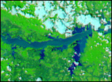
The lower image shows the region on September 9, 2006, and provides a perspective on normal conditions. Both images were created with a combination of visible and infrared light, which increases the contrast between water and land. In these images, water ranges from black to light blue, the color being lighter when the water is filled with sediment. Clouds are turquoise blue and white, plant-covered land is bright green, and bare earth, such as the cities or the beach, is tan. Red boxes outline regions where MODIS detected fires. Photo-like, true-color versions of the images are available from the MODIS Rapid Response Team.
NASA images courtesy the MODIS Rapid Response Team at NASA GSFC.