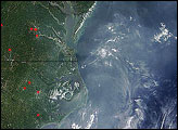
Haze hung over the U.S. East Coast on April 19, 2005, lowering the air quality in many eastern cities, though none reached the EPA's "Code Red" category—unhealthy—. In a few cities, the levels of ozone and particulate matter 2.5 micrometers in diameter or larger entered the range of orange, which indicates the air could be unhealthy for people in sensitive groups, such as the elderly or people with respiratory conditions like asthma.
This image of the area was captured by the Moderate Resolution Imaging Spectroradiometer (MODIS) on NASA’s Terra satellite and stretches from New York southward to North Carolina, encompassing several large Eastern cities, including New York City, Philadelphia, Baltimore, and Washington, D.C. The grayish haze extends outward over the Atlantic Ocean (image right).
For more on regional and national air pollution, visit the Environmental Protection Agency’s Air Now Website. To read about how NASA satellite data help air quality forecasters to predict regional air quality, read the feature story A New IDEA in Air Quality Forecasting.Image courtesy the MODIS Rapid Response Team, NASA-Goddard Space Flight Center