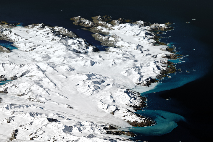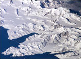
This photograph from the International Space Station (ISS) shows the eastern half of South Georgia Island. At 54 degrees South latitude, snow and ice are permanent everywhere on the island except at altitudes near sea level, where temperatures are higher.
Glaciers sourced in mountain snow and ice—eleven peaks rise higher than 2,000 meters (6,500 feet) above sea level—can be seen reaching the sea (such as at image lower right). Calving icebergs float away from the ice front at image lower right. The island’s glaciers are a major source of erosion. As the ice grinds over rock and soil, it produces fine sediments, known as glacial flour, that impart a milky color to water. The sediment appears as a lighter-toned zone offshore around the island. (Note that in this image, north is to the lower right.)
South Georgia and the South Sandwich Islands, a British overseas territory, are a remote string of islands in the southern Atlantic Ocean. In 1882–1883, a German scientific expedition stationed at Royal Bay (center left) observed the transit of Venus and, amazingly, recorded waves that originated 12,330 kilometers (7,660 miles) away with the eruption of Krakatau.
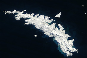
South Georgia is 170 kilometers long and by far the largest island in the territory, though the current population is less than 50 people. The main revenue comes from fishing licenses, which allow access to rich fishing grounds. Other revenue comes from tourism, customs and harbor dues, and the sale of postage stamps; most of that revenue is spent on fishery protection and research.
While the ISS only orbits above locations between 52 degrees North and South latitude, astronauts using handheld cameras can take images of regions at higher latitudes by using long focal-length lenses and high viewing angles. Such images tend to highlight topographic relief due to shadowing effects (image left) and look similar to the view you might get out of a commercial airliner window.
Astronaut photograph ISS035-E-18807 was acquired on April 13, 2013, with a Nikon D3S digital camera using a 400 millimeter lens, and is provided by the ISS Crew Earth Observations experiment and Image Science & Analysis Laboratory, Johnson Space Center. The image was taken by the Expedition 35 crew. It has been cropped and enhanced to improve contrast, and lens artifacts have been removed. The International Space Station Program supports the laboratory as part of the ISS National Lab to help astronauts take pictures of Earth that will be of the greatest value to scientists and the public, and to make those images freely available on the Internet. Additional images taken by astronauts and cosmonauts can be viewed at the NASA/JSC Gateway to Astronaut Photography of Earth. Caption by M. Justin Wilkinson, Jacobs/ESCG at NASA-JSC.