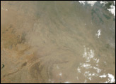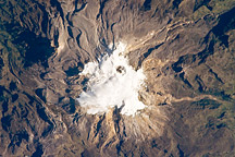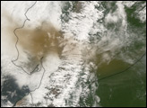
Nevado del Huila Volcano in Colombia is actually a volcanic chain running north to south, capped by a glacier. With peaks ranging in height from 2,600 to 5,780 meters (8,530 to 18,960 feet), Nevado del Huila is a stratovolcano composed of alternating layers of hardened lava, solidified ash, and volcanic rocks. Its first recorded eruption occurred in the mid-sixteenth century. The long-dormant volcano erupted again in mid-April 2007.
A few months before the eruption, the Advanced Spaceborne Thermal Emission and Reflection Radiometer (ASTER) on NASA’s Terra satellite captured this image of Nevado del Huila, on February 23, 2007. In this image, the bright white area just east of the central summit is ice. Immediately west of the summit are bare rocks, appearing as blue-gray. West of those rocks, white reappears, but this patch of white results from clouds hovering in the nearby valley. In the east, the colors turn to brown (indicating bare rock) and bright green (indicating vegetation).
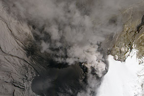
ASTER photographed Nevado del Huila near the end of a long phase of quietude. On April 17, 2007, local authorities recorded seismic activity associated with rock fracturing on the volcano’s central summit, according to the ReliefWeb Website. Activity intensified the following day with an eruption and mudflows, forcing thousands of nearby residents to evacuate. As the Associated Press reported, the eruption caused avalanches and floods that wiped away both houses and bridges. It marked the volcano’s first recorded eruption since the Spanish colonized the area five centuries earlier.
You can download a 15-meter-resolution KMZ file of Nevado del Huila for use with Google Earth.
NASA image created by Jesse Allen, using data provided courtesy of the NASA/GSFC/MITI/ERSDAC/JAROS, and U.S./Japan ASTER Science Team.