For a meteorologist monitoring tropical storms and hurricanes, pinpointing the eye of the storm—knowing when an eye has formed, and its size and location—is key to forecasting the storm’s strength and path. Recently, NASA-funded scientists discovered a new way to monitor the eye of tropical storms: by using satellite observations of the atmospheric gas ozone (a triplet of oxygen atoms).
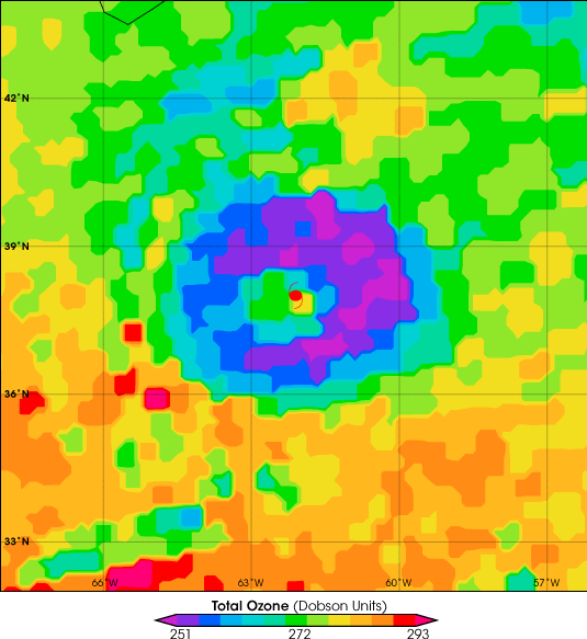
This colorful image shows ozone measurements collected over Hurricane Erin on September 12, 2001. Erin’s eye is marked with a red hurricane symbol. In the eye, ozone concentrations are elevated (yellow and green). The core is surrounded by an area of much lower ozone concentrations (purple and blue). These ozone measurements were made by the TOMS (Total Ozone Mapping Spectrometer) sensor on NASA’s Earth Probe satellite.
Why would ozone be a good indicator of the location and structure of the hurricane’s eye? Concentrations of naturally-occurring ozone (the kind that protects us from harmful ultraviolet radiation) are highest in the stratosphere, which is the layer of the atmosphere between about 10 and 30 miles above the surface. Air nearer to the ocean surface is less rich in ozone.
Surrounding the eye of a hurricane is a ring of powerful thunderstorms that are sucking up warm, moist air from the ocean surface and hurling it miles into the atmosphere—sometimes all the way to the lower stratosphere. This ozone-poor air replaces the ozone-rich air, causing ozone concentrations to drop. The process reverses in the eye itself: high-altitude air sinks down to the surface, infusing the entire column of atmosphere with ozone. Dropping ozone levels around the eye may turn out to be a strong sign that a storm is strengthening.
For more about the role ozone observations could play in tracking and forecasting hurricanes, read the NASA press release.
Image courtesy X. Zou and Yonghui Wu, Florida State University