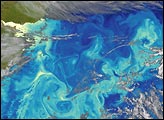
The oceans off Africa's southern tip, the "Cape of Good Hope", are widely known as an area of rugged weather and mean seas. Strong weather fronts and large low-pressure systems spawned off of Antarctica can arrive quickly, with powerful winds and driving rain. Cloud cover is usually extensive, caused when warm, moisture-laden air from the coast encounters cold air over the chill waters of the circling Southern Ocean currents. The Agulhas Current and the Agulhas Retroflection can give rise to immense "rogue waves" that can even threaten supertankers. For that reason, mariners who successfully navigated the Cape of Good Hope frequently breathed a sigh of relief.
On rare occasions, however, the clouds part and provide a spectacular view for hundreds of miles. The Sea-viewing Wide Field of view Sensor (SeaWiFS) was in just the right position over South Africa on March 28, 1999, capturing an impressive view of the Agulhas Retroflection and immediately sending the telemetry to the ground station in Pretoria. In this image, a large, straight convergence zone is marked by high productivity waters (the higher chlorophyll concentrations appear as red, orange, and yellow in this false color image) where the Agulhas Current makes a nearly right-angled turn to the south. The strong dynamics of this area can be seen in the marbelized patterns of eddies to the south and east of the convergence zone. To the northwest, upwelling in the Benguela upwelling zone is also made obvious by the high chlorophyll concentrations.
Image courtesy SeaWiFS; text by Jim Acker, Goddard DAAC