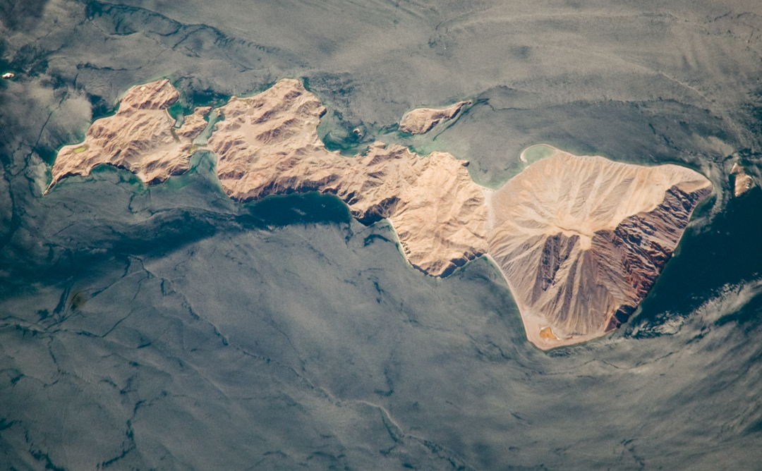
Located in the Bahia de los Angeles—Bay of the Angels—Isla Coronado (Coronado Island, also known as “Smith Island” on some maps) sits in the Gulf of California, just off the eastern shoreline of Mexico’s Baja Peninsula. The island is approximately 7 kilometers long, and it is dominated by Volcan (volcano) Coronado on the northern end. The date of the last eruption of the volcano is not known, but gas and steam activity was last recorded in 1539.
Coronado Island—together with nearby Isla Mitlan and Isla Calavera—has an arid climate and is sparsely vegetated. Despite the harshness of the environment, sea lion colonies can be found on the island, and the Bahia de los Angeles is a popular sport fishing location. Partly in response to increased environmental pressure on the islands from both fishing and tourism, local groups developed a management and conservation plan for the islands in the bay, with international support, in the late 1990s.
The island is an important piece of the ecology of the Gulf of California. In 1940, marine biologist Ed Ricketts, together with his friend, author John Steinbeck, conducted an expedition and collecting trip in the Sea of Cortez (now known as the Gulf of California) to explore the rich ecology of the intertidal zone. Coronado Island and the Bahia de los Angeles were part of that expedition. The resulting book by Steinbeck and Ricketts, Sea of Cortez, remains a classic document of the natural history and ecology of the Gulf of California. At the time, the marine environment around Coronado appeared to Ricketts and Steinbeck as sterile (in their words, “burned”) compared to the rest of the Gulf.
Today, the uninhabited island is a refuge with a rich marine assemblage, especially when compared to other, unprotected parts of the Gulf. This image provides hints of the diverse marine environment around the island. Most of the coast is steep and rocky, but lighter blue lagoons, especially along the western coast, provide shallower, protected environments that are biologically robust. Offshore, internal waves and complex surface currents facilitate mixing of the water, important for nutrient delivery to the coastal environments. These water patterns are outlined by sunglint (light reflecting off of the water surface back towards the camera onboard the International Space Station). The sunglint patterns are due to wind and currents, which roughen the water surface and enhance reflection, and surfactants that decrease the surface tension and roughness, resulting in regions of dark, smooth water.
Astronaut photograph ISS017-E-18044 was acquired on October 1, 2008, with a Nikon D2Xs digital camera fitted with an 800 mm lens, and is provided by the ISS Crew Earth Observations experiment and the Image Science & Analysis Laboratory, Johnson Space Center. The image was taken by the Expedition 17 crew. The image in this article has been cropped and enhanced to improve contrast. Lens artifacts have been removed. The International Space Station Program supports the laboratory to help astronauts take pictures of Earth that will be of the greatest value to scientists and the public, and to make those images freely available on the Internet. Additional images taken by astronauts and cosmonauts can be viewed at the NASA/JSC Gateway to Astronaut Photography of Earth. Caption by William L. Stefanov and Cynthia A. Evans, NASA-JSC.