A New Tool for Tectonics |
|||
"From the start our goal has been to make all of this information available to the public," Yates explained. The researchers have held to this initial objective; they recently posted their maps on their web site (http://denali.gsfc.nasa.gov/dtam/ —no longer available) in a number of different formats that anyone can download or print. When overlaid on transparencies, the maps all match up point for point. Yates said that the maps are likely to provide researchers with a much needed reference tool. On these digital maps, geologists can find features not found on any other global map of tectonic activity. In the past a scientist would have had to pore through stacks of research papers to locate the two large active faults running through the Russian Ural Mountains in the center of the Eurasian Plate or the dozen or so fractures that scar Tibet and southwestern China. With the DTAM, they should now be able to see where these features exist at a glance before making a trip to the library. Regardless of how working scientists use these maps, both Lowman and Yates believe that the real impact of their research will be on educators and students. Already, several textbook manufacturers have shown interest in the maps. "If the maps do become a standard in the classroom, we’re hoping they will contribute to a paradigm shift in terms of how people view global tectonics," said Yates. For instance, looking at the digital tectonic activity map, it isn’t hard to notice that the African Plate and the Eurasian Plate are two of the slowest moving plates in the world, and should be both moving to the east. The tectonic activity at a plate’s boundaries should depend on the plate’s movement relative to the adjacent plate. Yet, the map also shows that the Mediterranean, which forms the boundary between these two plates, has one of the highest concentrations of faults, volcanoes and earthquakes in the world in spite of the slow movement (Lowman et al., 1999). By utilizing the DTAM instead of over-simplified "plate maps," educators and students of geology will be exposed to a synoptic view of global tectonics. The Goddard team hopes that when the students become geologists they may incorporate this knowledge into their research or even improve on the current theory of plate tectonics. "There’s a lot more to geology than just plates and we hope down the road somewhere geologists will start to recognize this," said Lowman. References 1. P. Lowman, J. Yates, J. O'Leary, D. Salisbury, P. Masuoka, and B. Montgomery, 1999: A Digital Tectonic Activity Map of the Earth, Journal of Geoscience Education, v. 47(5), 1999. 2. DTAM web site (http://denali.gsfc.nasa.gov/dtam/ —no longer available but archived at http://visibleearth.nasa.gov/view.php?id=88415) |
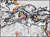 The Mediterranean Sea is one of the world’s most geologically active areas, even though the regional plate motion is relatively slow. (The blue, yellow, and red lines indicate different types of faults. Red dots represent volcanoes active within the past million years.) Several other areas of tectonic activity that are not well explained by conventional plate tectonics show up on the Digital Tectonic Activity Map. (View large image) | ||
